The Bighorn Mountains are a mountain range in northern Wyoming and southern Montana in the United States, forming a northwest-trending spur from the Rocky Mountains extending approximately 200 mi (320 km) northward on the Great Plains. They are separated from the Absaroka Range, which lie on the main branch of the Rockies to the west, by the Bighorn Basin. Much of the land is contained within the Bighorn National Forest.
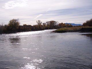
The Jefferson River is a tributary of the Missouri River, approximately 83 miles (134 km) long, in the U.S. state of Montana. The Jefferson River and the Madison River form the official beginning of the Missouri at Missouri Headwaters State Park near Three Forks. It is joined 0.6 miles (1.0 km) downstream (northeast) by the Gallatin.
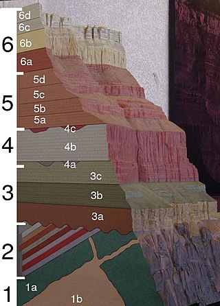
The geology of the Grand Canyon area includes one of the most complete and studied sequences of rock on Earth. The nearly 40 major sedimentary rock layers exposed in the Grand Canyon and in the Grand Canyon National Park area range in age from about 200 million to nearly 2 billion years old. Most were deposited in warm, shallow seas and near ancient, long-gone sea shores in western North America. Both marine and terrestrial sediments are represented, including lithified sand dunes from an extinct desert. There are at least 14 known unconformities in the geologic record found in the Grand Canyon.

Helena National Forest is located in west-central Montana, in the United States. Covering 984,558 acres (3,984.36 km2), the forest is broken into several separate sections. The eastern regions are dominated by the Big Belt Mountains, and are the location of the Gates of the Mountains Wilderness, which remains much as it did when the Lewis and Clark Expedition passed through the region. The western sections have both the continental divide and the Scapegoat Wilderness area, which is part of the Bob Marshall Wilderness complex. The southern region includes the Elkhorn Mountains. The forest is composed of a mixture of grass and sagebrush covered lowlands with "island" pockets of lodgepole pine and more mountainous areas where Douglas fir, spruce and larch can be found. The rocky mountains in the region do not exceed 10,000 feet.
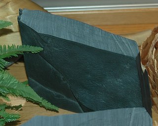
Argillite is a fine-grained sedimentary rock composed predominantly of indurated clay particles. Argillaceous rocks are basically lithified muds and oozes. They contain variable amounts of silt-sized particles. The argillites grade into shale when the fissile layering typical of shale is developed. Another name for poorly lithified argillites is mudstone. These rocks, although variable in composition, are typically high in aluminium and silica with variable alkali and alkaline earth cations. The term pelitic or pelite is often applied to these sediments and rocks. Metamorphism of argillites produces slate, phyllite, and pelitic schist.
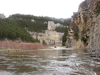
The Gates of the Mountains Wilderness is located in the U.S. state of Montana. Created by an act of Congress in 1964, the wilderness is managed by Helena National Forest. A day use campground near the Gates of the Mountains, Meriwether Picnic site, is named in honor of Meriwether Lewis.

Canyon Ferry Lake is a reservoir on the Missouri River near Helena, Montana and Townsend, Montana. It is Montana's third largest body of water, covering 35,181 acres (142 km2) and 76 miles (122 km) of shore (1). It was formed by the building of Canyon Ferry Dam, which was completed in 1954 and has been used for electricity, irrigation, and flood controls since.

The Mission Mountains or Mission Range are a range of the Rocky Mountains located in northwestern Montana in the United States. They lie chiefly in Lake County and Missoula County and are south and east of Flathead Lake and west of the Swan Range. On the east side of the range is the Swan River Valley and on the west side the Mission Valley.

The Tobacco Root Mountains lie in the northern Rocky Mountains, between the Jefferson and Madison Rivers in southwest Montana. The highest peak is Hollowtop at 10,604 feet (3,232 m). The range contains 43 peaks rising to elevations greater than 10,000 feet (3048 m).

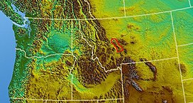
Montana is one of the eight Mountain States, located in the north of the region known as the Western United States. It borders North Dakota and South Dakota to the east. Wyoming is to the south, Idaho is to the west and southwest, and the Canadian provinces of British Columbia, Alberta, and Saskatchewan are to the north, making it the only state to border three Canadian provinces.

The Coyote Mountains are a small mountain range in San Diego and Imperial Counties in southern California. The Coyotes form a narrow ESE trending 2 mi (3.2 km) wide range with a length of about 12 mi (19 km). The southeast end turns and forms a 2 mi (3.2 km) north trending "hook". The highest point is Carrizo Mountain on the northeast end with an elevation of 2,408 feet (734 m). Mine Peak at the northwest end of the range has an elevation of 1,850 ft (560 m). Coyote Wash along I-8 along the southeast margin of the range is 100 to 300 feet in elevation. Plaster City lies in the Yuha Desert about 5.5 mi (8.9 km) east of the east end of the range.
The Little Belt Mountains are a section of the Rocky Mountains in the U.S. state of Montana. Situated mainly in the Lewis and Clark National Forest, the mountains are used for logging and recreation for the residents of Great Falls, Montana. Showdown is a ski area located within the mountains located off US Highway 89 which splits the mountains in half connecting White Sulphur Springs and Belt, MT. The highest point in the Little Belt Range is Big Baldy Mountain at 9,467 feet (2,886 m).

The Shonkin Sag is a prehistoric fluvioglacial landform located along the northern edge of the Highwood Mountains in the state of Montana in the United States. The Sag is a river channel formed by the Missouri River and glacial meltwater pouring from Glacial Lake Great Falls. It is one of the most famous prehistoric meltwater channels in the world.

Holter Dam is a hydroelectric straight gravity dam on the Missouri River about 45 miles (72 km) northeast of Helena, Montana, in the United States. The dam, which was built between 1908 and 1918, is 1,364 feet (416 m) long and 124 feet (38 m) high. The reservoir formed by the dam, Holter Lake is 25 miles (40 km) long and has a storage capacity of 243,000 acre-feet (300,000,000 m3) of water when full. The dam is a "run-of-the-river" dam because it can generate electricity without needing to store additional water supplies behind the dam.

Confederate Gulch is a steeply incised gulch or valley on the west-facing slopes of the Big Belt Mountains in the U.S. state of Montana. Its small stream drains westward into Canyon Ferry Lake, on the upper Missouri River near present-day Townsend, Montana. In 1864, Confederate soldiers on parole during the American Civil War made a minor gold discovery in the gulch, but the discovery of the sensationally rich Montana Bar the following year—one of the richest placer strikes per acre ever made—led to other rich gold strikes up and down the gulch, and touched off a frantic boom period of placer gold mining in the area that extended through 1869. From 1866 to 1869, the gulch equaled or outstripped all other mining camps in the Montana Territory in gold production, producing an estimated $19–30 million worth of gold. For a time, Confederate Gulch was the largest community in Montana. In 1866, Montana had a total population of 28,000, and of these, about 10,000 (35%) were working in Confederate Gulch.

The Caballo Mountains, are a mountain range located in Sierra and Doña Ana Counties, New Mexico, United States. The range is located east of the Rio Grande and Caballo Lake, and west of the Jornada del Muerto; the south of the range extends into northwest Doña Ana County. The nearest towns are Truth or Consequences and Hatch.
Camp Cooke also known as Fort Claggett was a U.S. Army military post on the Missouri River in Montana Territory. The camp was established on July 10, 1866, just upstream from the mouth of the Judith River by the 13th Infantry Regiment. By 1867 Camp Cooke had a strength of approximately 400 men. The army established the post to protect steamboat traffic en route to Fort Benton. The boats carried passengers and freight to supply swiftly growing boom towns at the site of rich gold strikes in the western mountains of the Montana Territory.

Tower Rock State Park is a state park near the community of Cascade in the U.S. state of Montana in the United States. The centerpiece of the park is Tower Rock, a 424-foot (129 m)-high rock formation which marks the entrance to the Missouri River Canyon in the Adel Mountains Volcanic Field. It was well known to Native Americans, and considered a sacred place by the Piegan Blackfeet. Tower Rock received its current name when Meriwether Lewis of the Lewis and Clark Expedition visited the site in 1805. Railroad and highway development in the late 1800s and 1900s skirted Tower Rock, but the landform itself remained pristine. The 87.2 acres (0.353 km2) encompassing Tower Rock was added to the National Register of Historic Places on March 18, 2002. The 140-acre (0.57 km2) Tower Rock State Park was created around the National Historic Site in 2004.
The geology of Montana includes thick sequences of Paleozoic, Mesozoic and Cenozoic sedimentary rocks overlying ancient Archean and Proterozoic crystalline basement rock. Eastern Montana has considerable oil and gas resources, while the uplifted Rocky Mountains in the west, which resulted from the Laramide orogeny and other tectonic events have locations with metal ore.

The geology of California is highly complex, with numerous mountain ranges, substantial faulting and tectonic activity, rich natural resources and a history of both ancient and comparatively recent intense geological activity. The area formed as a series of small island arcs, deep-ocean sediments and mafic oceanic crust accreted to the western edge of North America, producing a series of deep basins and high mountain ranges.