
Jefferson City is an unincorporated community and census-designated place (CDP) in Jefferson County, Montana, United States. The population was 472 at the 2010 census. It is part of the Helena Micropolitan Statistical Area.

Helena Valley Northeast is a census-designated place (CDP) in Lewis and Clark County, Montana, United States. The population was 2,995 at the 2010 census. It is part of the Helena Micropolitan Statistical Area.

Helena Valley Southeast is a census-designated place (CDP) in Lewis and Clark County, Montana, United States. The population was 8,227 at the 2010 census. It is part of the Helena Micropolitan Statistical Area.

Helena Valley West Central is a census-designated place (CDP) in Lewis and Clark County, Montana, United States. The population was 7,883 at the 2010 census. It is part of the Helena Micropolitan Statistical Area.

Clancy is an unincorporated community and census-designated place (CDP) in Jefferson County, Montana, United States. The population was 1,661 at the 2010 census, up from 1,406 in 2000. It is part of the Helena Micropolitan Statistical Area.

Helena West Side is a census-designated place (CDP) in Lewis and Clark County, Montana, United States. The population was 1,637 at the 2010 census, down from 1,711 at the 2000 census due to annexation of part of the CDP by the city of Helena. It is part of the Helena Micropolitan Statistical Area.

The Lake Charles metropolitan statistical area is a metropolitan area in the Acadiana region of southwest Louisiana that covers three parishes—Calcasieu, Cameron, and Jefferson Davis. According to a 2019 census estimate, the MSA had a population of 210,409. It is also part of the larger Lake Charles–DeRidder combined statistical area which had a population of 241,777 in 2019. The Lake Charles MSA also shares borders with the Beaumont–Port Arthur metropolitan area to the west. Metropolitan Lake Charles, the principal city, is commonly referred to as the Lake Area.
The Charleston Metropolitan Statistical Area, as defined by the United States Census Bureau, is an area consisting of three counties in West Virginia, anchored by the city of Charleston. It is the largest metropolitan area entirely within the state of West Virginia. The Huntington Metro Area adds to the Charleston–Huntington, WV-OH-KY CSA and spans three states, while the core county of the Charleston area, Kanawha County, is more populous than the West Virginia portion of the Huntington area.

The Gulfport-Biloxi Metropolitan Statistical Area is a metropolitan statistical area (MSA) in the Mississippi Gulf Coast region that includes four counties – Hancock, Harrison, Jackson and Stone. The principal cities are Gulfport and Biloxi. The 2010 census placed the Gulfport-Biloxi MSA population at 388,488, though as of 2019, it was estimated to have increased to 417,665. The area was significantly impacted by Hurricane Katrina on August 29, 2005, and prior to the hurricane, had experienced steady to moderate population growth. However, growth has since rebounded, with the population steadily increasing every year throughout the 2010s.
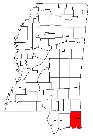
The Pascagoula Metropolitan Statistical Area was a metropolitan area in the southeastern corner of Mississippi that covered two counties - Jackson and George. As of the 2000 census, the MSA had a population of 150,564. The area was significantly impacted by Hurricane Katrina in 2005. A July 1, 2009 estimate placed the population at 155,603. Prior to the hurricane, the area had experienced steady population growth. It was also part of the larger Gulfport-Biloxi-Pascagoula Combined Statistical Area.

The Wichita Falls metropolitan statistical area is a metropolitan area in North Texas that covers three counties – Archer, Clay, and Wichita. As of the 2010 census, the MSA had a population of 151,306.
College Station–Bryan is a metropolitan area centering on the twin cities of Bryan and College Station, Texas, in the Brazos Valley region of Texas. The 2010 census placed the population of the three county metropolitan area at 255,519. The 2019 population estimate was 273,101.

The Rapid City, SD metropolitan area, as defined by the United States Census Bureau. Anchored by the city of Rapid City, the area corresponds to the entirety of Pennington and Meade counties in the state of South Dakota, though the Rapid City market area extends well beyond those counties and into Nebraska, Montana, Wyoming, and North Dakota. The population was 139,074 at the 2020 census. According to 2022 census estimates, the MSA is estimated to have a population of 145,159.

The Rockford Metropolitan Statistical Area, as defined by the United States Census Bureau, is an area consisting of four counties in north-central Illinois, anchored by the city of Rockford. As of the 2010 census, the MSA had a population of 349,431. The Rockford MSA abuts the southern portions of the Janesville-Beloit MSA and the Chicago MSA. It forms the main part of the larger Rockford–Freeport–Rochelle Combined Statistical Area.

The Idaho Falls Metropolitan Statistical Area, as defined by the United States Census Bureau, is an area consisting of three counties in eastern Idaho, anchored by the city of Idaho Falls. As of the 2020 census, the MSA had a population of 154,855. It is just north of the Pocatello, Idaho Metropolitan Area.

The Topeka Metropolitan Statistical Area, as defined by the United States Census Bureau, is an area consisting of five counties in northeastern Kansas, anchored by the city of Topeka. In total, it has an area of 3,290.15 square miles. As of the 2010 census, the MSA had a population of 233,870.

The South Bend–Mishawaka Metropolitan Statistical Area, sometimes referred to as Michiana, as defined by the United States Census Bureau, is an area consisting of two counties – one in northern Indiana and one in southwest Michigan (Cass), anchored by the cities of South Bend and Mishawaka in Indiana. As of the 2010 census, the MSA had a population of 319,224.

The Macon metropolitan area is a metropolitan statistical area consisting of five counties in Central Georgia, anchored by the principal city of Macon. At the 2010 U.S. census, the five-county area had a population of 232,293. A July 2017 estimate placed the population at 228,914. In 2022, its estimated population was 235,805.

The Grand Rapids metropolitan area is a triangular shaped Metro Triplex, in West Michigan, which fans out westward from the primary hub city of Grand Rapids, Michigan, to the other two metro hubs of Muskegon and Holland. The metropolitan area had an estimated population of 1,059,113 in 2017. The region, noted in particular for its western edge abutting the Lake Michigan shoreline and its beaches, is a popular tourist and vacation destination during the summer. Noted popular metro area beach towns include Grand Haven, Holland, Muskegon, and Saugatuck.

The Hilton Head Island metropolitan area, officially the Hilton Head Island–Bluffton–Port Royal, SC Metropolitan Statistical Area as defined by the United States Census Bureau, is a metropolitan statistical area consisting of the two southernmost counties in the Lowcountry region of South Carolina, centered on the resort town of Hilton Head Island. As of the 2020 census, the MSA had a population of 215,908. Prior to March 2013, the region was considered a micropolitan statistical area.

