
Meade County is a county in the U.S. state of South Dakota. As of the 2020 census, the population was 29,852, making it the 6th most populous county in South Dakota. Its county seat is Sturgis. The county was created in 1889 and named for Fort Meade, which was garrisoned as a United States military post in the area in 1878 and itself named for General George Meade.

Black Hawk is an unincorporated census-designated place (CDP) in Meade County, South Dakota, United States. The population was 3,026 at the 2020 census. Black Hawk has been assigned the ZIP code of 57718. Located along Interstate 90, Black Hawk is part of the Rapid City metropolitan area.

Ashland Heights is a census-designated place (CDP) and unincorporated community in Pennington County, South Dakota, United States. The population was 678 at the 2020 census.

Colonial Pine Hills is a census-designated place (CDP) and unincorporated community in Pennington County, South Dakota, United States. The population was 1,903 at the 2020 census.

Green Valley is a census-designated place (CDP) and unincorporated community in Pennington County, South Dakota, United States. The population was 1,051 at the 2020 census.

Rapid Valley is a census-designated place (CDP) and unincorporated community in Pennington County, South Dakota, United States, and a suburb of Rapid City. The population was 8,098 at the 2020 census. Rapid Valley has been a retreat for people living in Rapid City due to its low crime, cheap land, and views of the Black Hills. Rapid Valley is home to many industrial and financial businesses, and is the headquarters for many corporations specializing in transport and engineering.
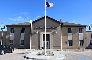
Box Elder is a city in Pennington and Meade counties in the State of South Dakota. The population was 11,746 at the 2020 census, making it the 11th most populous city in South Dakota. Ellsworth Air Force Base lies on the northeast side of the city.

The Charlottesville Metropolitan Statistical Area is a Metropolitan Statistical Area (MSA) in the Piedmont region of the Commonwealth of Virginia as defined by the Office of Management and Budget (OMB). The combined population is: 201,559, 218,615, and 235,232.

The Billings Metropolitan Statistical Area is the largest metropolitan area in the U.S. state of Montana. Located in the south central portion of the state, its population is 184,167 as of 2020.

The Alexandria Metropolitan Statistical Area is a metropolitan area in central Louisiana that covers two parishes – Rapides and Grant. As of the 2000 census, the MSA had a population of 145,035.

The Monroe metropolitan area, officially the Monroe metropolitan statistical area, is a metropolitan statistical area in Northern Louisiana that covers three parishes—Ouachita, Union, and Morehouse. According to the 2020 census, the MSA had a population of 207,104.

Summerset is a city in Meade County, South Dakota, United States. The population was 2,972 at the 2020 census. Located in the western part of the state, it is the first city to incorporate in the state since 1985.

The Hattiesburg Metropolitan Statistical Area is a metropolitan statistical area (MSA) in southeastern Mississippi that covers four counties - Covington, Forrest, Lamar, and Perry. The MSA's principal city is Hattiesburg. The 2010 census placed the Hattiesburg MSA's population at 162,410, though estimates as of 2019 indicate the population has increased to 168,849. The area is part of the geographical region known as the Pine Belt, famous for its abundance of longleaf pine trees. The Hattiesburg MSA is part of the larger Hattiesburg-Laurel Combined Statistical Area.

The Gulfport-Biloxi Metropolitan Statistical Area is a metropolitan statistical area (MSA) in the Mississippi Gulf Coast region that includes four counties – Hancock, Harrison, Jackson and Stone. The principal cities are Gulfport and Biloxi. The 2010 census placed the Gulfport-Biloxi MSA population at 388,488, though as of 2019, it was estimated to have increased to 417,665. The area was significantly impacted by Hurricane Katrina on August 29, 2005, and prior to the hurricane, had experienced steady to moderate population growth. However, growth has since rebounded, with the population steadily increasing every year throughout the 2010s.

The Hinesville metropolitan area, officially the Hinesville metropolitan statistical area and previously the Hinesville–Ft. Stewart metropolitan statistical area, is defined by the U.S. Office of Management and Budget as a metropolitan statistical area consisting of two counties, Liberty and Long, in the U.S. state of Georgia. It is anchored by the city of Hinesville and encompasses all of Fort Stewart, one of the largest U.S. Army installations in the United States.

The Idaho Falls Metropolitan Statistical Area, as defined by the United States Census Bureau, is an area consisting of two counties in eastern Idaho, anchored by the city of Idaho Falls. As of the 2020 census, the MSA had a population of 154,855. It is just north of the Pocatello, Idaho Metropolitan Area.
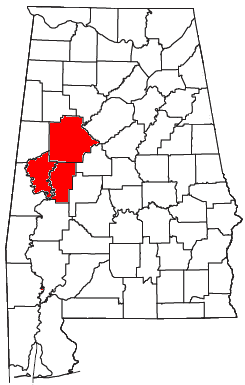
The Tuscaloosa metropolitan area, as defined by the United States Census Bureau, is an area consisting of three counties in west central Alabama, anchored by the city of Tuscaloosa. As of the 2020 census, the MSA had a population of 268,674.

The Owensboro Metropolitan Statistical Area, as defined by the United States Census Bureau, is an area consisting of three counties in Kentucky, anchored by the city of Owensboro. As of the 2000 census, the MSA had a population of 109,875. In the 2010 Census the population was 114,752. Owensboro is part of the Illinois–Indiana–Kentucky tri-state area and sometimes, albeit seldom, referred to as Kentuckiana.

The Elizabethtown–Fort Knox Metropolitan Statistical Area, as defined by the United States Census Bureau, is an area consisting of two counties in Kentucky, anchored by the city of Elizabethtown and the nearby Fort Knox Army post. As of the 2020 census, the MSA had a population of 155,572.

The Canton–Massillon Metropolitan Statistical Area, as defined by the United States Census Bureau, is an area consisting of two counties in Northeast Ohio, anchored by the cities of Canton and Massillon. As of the 2020 census, the MSA had a population of 401,574. The MSA is also part of the Cleveland–Akron–Canton, OH Combined Statistical Area, which had a population of 3,633,962 in 2020, making it the largest CSA in Ohio.