17-Mile Drive

Last updated
17-Mile Drive
17-mile drive 1.jpg
17 Mile Drive near Spanish Bay Road
Type Scenic toll road
Maintained by Pebble Beach Company
Length17 mi (27 km)
FromDel Monte Blvd in Pacific Grove
Major
junctions
California 68.svg SR 68  / Sunset Dr
Carmel Way
ToCalifornia 68.svgCalifornia 1.svg SR 68  / SR 1
Construction
Completion1880
Other
Website Scenic 17-Mile Drive

17-Mile Drive is a scenic road through Pebble Beach and Pacific Grove on the Monterey Peninsula in California, much of which hugs the Pacific coastline and passes famous golf courses, mansions and scenic attractions, including the Lone Cypress, Bird Rock and the 5,300-acre Del Monte Forest of Monterey Cypress trees. [1]

Contents

The drive serves as the main road through the gated community of Pebble Beach. Inside this community, nonresidents have to pay a toll to use the road. [2] Like the community, the majority of 17-Mile Drive is owned and operated by the Pebble Beach Corporation. The 17-Mile Drive is a 17-mile (27 km)-long scenic loop having five primary entrances - the main highway entrance at California State Route 1, and entrances in Carmel and Pacific Grove.

History

Original Hotel Del Monte, ca. 1885 Hotel Del Monte, Cal, by Watkins, Carleton E., 1829-1916.jpg
Original Hotel Del Monte, ca. 1885

In 1602 the Monterey Peninsula was mapped by Spanish explorers. By 1840 the area now called Pebble Beach was a rancho left to widow Carmen Garcia Barreto Maderiaga Maria by her husband. She sold the 4000 acre property for $500 in 1846. Ownership passed several times until 1862 when the property was purchased at auction for 12 cents an acre by David Jacks. At the time, the area was called "Stillwater Cove". Jacks leased the land to the "China Man Hop Company", a small village with a population of about 30 Chinese fishermen living in shacks built upon the rocky shoreline. [3]

In 1880, Jacks sold the land to the Pacific Improvement Company (PIC), a consortium of The Big Four railroad barons: Charles Crocker, Mark Hopkins, Collis Huntington and Leland Stanford. [4] [5] By 1892, the PIC laid out a scenic road that they called the 17-Mile Drive, meandering along the beaches and among the forested areas between Monterey and Carmel. [6] Within short order, the area became a tourist destination with the building of the Hotel Del Monte.

The hotel was the starting and finishing point for 17-Mile Drive, (originally called the 18-mile Drive by hotel operators). The drive was offered as a pleasure excursion to hotel guests, and was intended to attract wealthy buyers of large and scenic residential plots on PIC land. Sightseers riding horses or carriages along the 17-Mile Drive sometimes stopped at Pebble Beach to pick up agate and other stones polished smooth by the waves, and they commented on a few unusual tree formations known as the Witch Tree and the Ostrich Tree—the latter formed by two trees leaning on each other. At that time, the Chinese fishing community continued in existence despite mounting anti-Chinese sentiment among Monterey residents of European heritage. [7] At roadside stands, Chinese-American girls sold shells and polished pebbles to tourists. In the 1900s, the automobile began replacing horses on 17-Mile Drive, and by 1907 there were only automobiles. [8] The drive featured region's historical sites, forests, and on to the coastal scenic attractions in the Hotel Del Monte Park Reservation, as it was known at the time. [9]

The Hotel Del Monte rebuilt in 1926, now Herrmann Hall NPS herrmann hall lrg.jpg
The Hotel Del Monte rebuilt in 1926, now Herrmann Hall

Drawn by six bay horses, President Benjamin Harrison took the coach ride through the reservation in 1891. The coach was adorned with the national colors "and the harness on the horses was lined with bunting and roses as far as possible." In the newspaper The Monterey Cypress, President Harrison noted "This is a lovely spot. I only wish I could stay here a week." [10] In 1887, the hotel was destroyed by fire and replaced with a new structure. The Del Monte Golf Course was added in 1897 as part of the hotel and is today the oldest operating course west of the Mississippi. [11] In 1919, the Los Angeles Times called the 17-Mile Drive one of the "great wonders of the world." [10]

On February 27, 1919, Samuel Finley Brown Morse formed the Del Monte Properties Company, and acquired the extensive holdings of the Pacific Improvement Company, which included the Del Monte Forest and the Hotel Del Monte. [12] [13] Another fire destroyed that structure and was replaced by a third hotel. This new hotel was finished in 1926 and requisitioned by the United States government as a training facility in 1942. [11] After World War II, the Hotel del Monte building and surrounding grounds were acquired by the United States Navy for its Naval Postgraduate School and the building was renamed Herrmann Hall. The Del Monte Forest, including the famed 17-Mile Drive, remained under the ownership of Del Monte Properties Company.

On March 30, 1977, the Del Monte Properties Company was reincorporated as the Pebble Beach Corporation. [12] In May 1979, 20th Century Fox, later bought by Marvin Davis, purchased the Pebble Beach Corporation. [12] When the film company was sold to Rupert Murdoch in 1985, Davis kept several company assets not directly related to the film and TV industry, including the Pebble Beach Company. In 1990 Davis sold the company to Japanese businessman Minoru Isutani, [12] who made it a subsidiary of the Japanese resort company Taiheiyo Club Inc. under a holding company called the Lone Cypress Company. In 1999 the Pebble Beach Company was acquired from Cypress by an investor group led by Clint Eastwood, Arnold Palmer, and Peter Ueberroth.

Route description

Pacific Grove entrance 17 mile drive at Pacific Grove entrance.JPG
Pacific Grove entrance
17-Mile Drive
17-Mile Drive entrance gates

At the north end, a portion of the early route through Pacific Grove begins at the intersection of Del Monte Blvd and Esplanade Street. The famous portion of 17-Mile Drive then begins a few miles south of this point[ where? ]. The crossing of Highway 68 (Holman Highway/Sunset Drive) and 17-Mile Drive marks the entrance to Pebble Beach.

From the Sunset Drive/Pacific Grove gate, the drive runs inland past Spanish Bay, then adjacent to beaches and up into the coastal hills, providing scenic viewpoints. The route allows for self-directed travel and stopping, with frequent turnouts along the roadway in many locations along the route. Without stops, it takes a minimum of 20 minutes to reach Carmel. The numerous turnouts allow stopping to take pictures, or getting out to stroll along the ocean or among the trees. Visitors receive a map that points out some of the more scenic spots. In addition, a red-dashed line is marked in the center of the main road to guide visitors, and help prevent them from venturing into the adjacent neighborhood streets. [14]

Beach near the Pacific Grove entrance of the 17 Mile Drive 17 Mile Drive photo D Ramey Logan.jpg
Beach near the Pacific Grove entrance of the 17 Mile Drive
Beach access near golf links at Pebble Beach 17 Mile Drive cropped.jpg
Beach access near golf links at Pebble Beach
Bird Rock 17 Mile Drive Bird Rock.jpg
Bird Rock
Seal seen along 17-mile drive Seal Curiosity.JPG
Seal seen along 17-mile drive

Scenic attractions

The Lone Cypress Lone Cypress.jpg
The Lone Cypress

Primary scenic attractions include Cypress Point, Bird Rock, Point Joe, Pescadero Point, Fanshell Beach & Seal Point. The famous "Witch Tree" landmark, often used as scenic background in movies and television, was formerly at Pescadero Point. The tree was blown down by a storm on January 14, 1964. Pescadero Point is also the site of the Ghost Tree, a landmark Monterey Cypress tree. The tree gives its name to a dangerous extreme surfing location known to have storm waves. [15] Currently, the surf break of Ghost Tree is off limits to surfers and watercraft. [16]

Chief among the scenic attractions is the Lone Cypress, a salt-pruned Monterey cypress (macrocarpa) tree which is the official symbol of Pebble Beach and a frequent fixture of television broadcasts from this area. In 1990 the Monterey Journal reported that Pebble Beach's lawyer, Kerry C. Smith, said "The image of the tree has been trademarked by us," and that it intended to control any display of the cypress for commercial purposes. The company had warned photographers that "they cannot even use existing pictures of the tree for commercial purposes." [17] Other legal commentators have questioned the Pebble Beach Company's ability to invoke intellectual property laws to restrict others' use of such images. [18]

Related Research Articles

<span class="mw-page-title-main">Pacific Grove, California</span> City in California, United States

Pacific Grove is a coastal city in Monterey County, California, in the United States. The population at the 2020 census was 15,090. Pacific Grove is located between Point Pinos and Monterey.

<span class="mw-page-title-main">Del Monte Forest, California</span> Census-designated place in California, United States

Del Monte Forest is a census-designated place (CDP) in Monterey County, California, United States. As of the 2020 census, the CDP had a total population of 4,204, down from 4,514 at the 2010 census. The census area includes the separate well-known community of Pebble Beach.

<span class="mw-page-title-main">Pebble Beach, California</span> Unincorporated community in California, United States

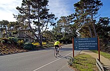
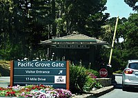
Pebble Beach is an unincorporated community on the Monterey Peninsula in Monterey County, California, United States. The small coastal residential community of mostly single-family homes is also notable as a resort destination, and the home of the golf courses of Cypress Point Club, Monterey Peninsula Country Club, and Pebble Beach Golf Links. Nonresidents are charged a toll to use 17-Mile Drive, the main road through Pebble Beach, making it a de-facto gated community.

<span class="mw-page-title-main">Pebble Beach Golf Links</span> Public golf course in California, U.S.

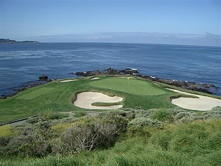
Pebble Beach Golf Links is a public golf course on the west coast of the United States, located in Pebble Beach, California.

<span class="mw-page-title-main">Lone Cypress</span> Monterey cypress tree in Pebble Beach, California, United States

The Lone Cypress is a Monterey cypress tree located in Pebble Beach, California. Standing atop a granite headland overlooking Carmel Bay, the tree has become a Western icon and has been called one of the most photographed trees in North America.

<span class="mw-page-title-main">Ghost Trees</span> Surfing location in Northern California, United States

Ghost Trees is a famed big wave surfing location off the 18th hole of Pebble Beach Golf Links in Pebble Beach, California. The wave breaks off the rock-strewn shoreline known as Pescadero Point. On rare winter days with the proper westerly angle, waves are focused by the deep Carmel Canyon to rear up as much as 60 ft (18 m) in height. Formerly known as Pesky's, Ghost Trees is considered one of the most dangerous waves in the world due to its slab shape, massive boils, strong current, bull kelp, and the underwater labyrinth of natural rock pillars in the impact zone. It is also frequented by white sharks.

Del Monte is a district of Monterey, California. It was formerly an independent unincorporated community in Monterey County. It is located in the east part of Monterey, at an elevation of 16 feet.

<span class="mw-page-title-main">Samuel Finley Brown Morse</span>

Samuel Finley Brown Morse was an American environmental conservationist and the developer of Pebble Beach. He was known as the Duke of Del Monte and ran his company from the 1919 until his death in 1969. Originally from the eastern United States, Morse moved west and fell in love with the Monterey Peninsula, eventually owning and preserving vast acreage while also developing golf courses and The Lodge at Pebble Beach.

Rancho Pescadero was a 4,426-acre (17.91 km2) Mexican land grant in present day Monterey County, California given in 1836 by Governor Nicolás Gutiérrez to Fabián Barreto. Pescadero means fishing place in Spanish. The grant extended along the Pacific coast from Rancho Punta de Pinos and Seal Rocks south to Carmel by the Sea and encompassed present day Pebble Beach, California.

<span class="mw-page-title-main">David Jacks (businessman)</span> American businessman (1822–1909)

David Jacks was a powerful Californian landowner, developer, and businessman. Born in Scotland, he emigrated to California during the 1849 Gold Rush, and soon acquired several thousand acres in and around Monterey, shaping the history of Monterey County in the first decades of American possession. He is also credited as being the first to market and popularize Monterey Jack cheese. He was born David Jack, but took to spelling his last name "Jacks" once in California.

<span class="mw-page-title-main">Marion Hollins</span> American golfer and golf course architect

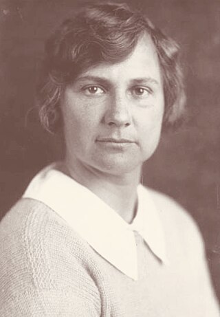
Marion B. Hollins was an American amateur golfer. She is known as an athlete and as a golf course developer, one of the only known female golf course developers in history. She won the 1921 U.S. Women's Amateur and was runner-up in 1913. She also had many other amateur wins. She was the captain of the first U.S. Curtis Cup team in 1932.

<span class="mw-page-title-main">Pacific Improvement Company</span> Holding company of the Southern Pacific Railroad

The Pacific Improvement Company (PIC) was a large holding company in California and an affiliate of the Southern Pacific Railroad. It was formed in 1878, by the Big Four, who were influential businessmen, philanthropists and railroad tycoons who funded the Central Pacific Railroad, (C.P.R.R.). These men were: Leland Stanford (1824–1893), Collis Potter Huntington (1821–1900), Mark Hopkins (1813–1878), and Charles Crocker (1822–1888). They owned the company, each with 25% interest. Archived records date from 1869 to 1931.

<span class="mw-page-title-main">Monterey Peninsula</span> Peninsula in California, USA

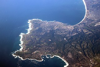
The Monterey Peninsula anchors the northern portion on the Central Coast of California and comprises the cities of Monterey, Carmel, and Pacific Grove, and the resort and community of Pebble Beach.

<span class="mw-page-title-main">Hotel Del Monte</span> Former hotel; current site of the U.S. Naval Postgraduate School

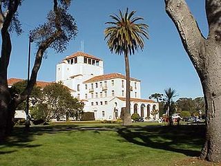
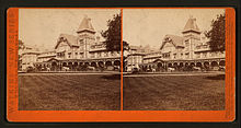
The Hotel Del Monte was a large resort hotel in Monterey, California, from its opening in 1880 until 1942. It was one of the finest luxury hotels in North America. During World War II, it closed and the building was leased to the United States Navy. It was first used by the Navy as a school where enlisted men spent the second, third, and fourth months of an eleven-month course being trained as electronic technicians. Later the Hotel Del Monte became the Naval Postgraduate School. Today, the building is called Herrmann Hall. It contains school administrative offices and the Navy Gateway Inns and Suites, a hotel.

<span class="mw-page-title-main">Carmel Woods</span> The unincorporated area north of Carmel-by-the-Sea, California

Carmel Woods is an unincorporated community in Monterey County, California, United States. It is located adjoining the northern city limits of Carmel-by-the-Sea and adjacent to Pebble Beach. Carmel Woods was laid out in 1922 by developer Samuel F. B. Morse (1885-1969). It included a 25-acre (0.10 km2) subdivision with 119 building lots. Carmel Woods was one of three major land developments adjacent to the Carmel city limits between 1922 and 1925. The other two were the Hatton Fields, a 233 acres (94 ha) between the eastern town limit and Highway 1, and the Walker Tract to the south, which was 216 acres (87 ha) of the Martin Ranch called The Point.

<span class="mw-page-title-main">Thomas Albert Work</span> American businessman and banker

Thomas Albert Work was an American businessman and banker of Pacific Grove, California, known around Monterey as T. A. Work. He was owner of the T. A. Work company that made him the single largest business property owner on the Monterey Peninsula. He owned several banks, including the First National Bank of Monterey, Bank of Pacific Grove, Salinas, and the Bank of Carmel.

<span class="mw-page-title-main">Julian P. Graham</span> American artist

Julian Pitzer Graham, nicknamed “Spike” was an American photographer. His legacy is over 40,000 photographs and negatives of many famous people that visited and lived on the Monterey Peninsula. Between 1924 and 1963, Graham, was an independent, official photographer for Del Monte Properties, which is known today as the Pebble Beach Company. His photographs appeared in magazines such as Life and National Geographic, national and international newspapers, books, fashion layouts, and promotional material used for advertising the Pebble Beach Company. Graham's photographs chronicle the history of the Monterey Peninsula which includes the creation of Cypress Point Golf Club, Pebble Beach Golf Links and the Monterey Peninsula Country Club. His career lasted 39 years until his death at his home in Carmel Valley, California on March 13, 1963.

<span class="mw-page-title-main">El Carmelo Hotel</span> Historic Hotel

El Carmelo Hotel was Pacific Grove's first hotel, opened to guests on May 20, 1887. It was sometimes called the sister of the Hotel Del Monte. It was located on Lighthouse Avenue between Fountain and Grand Avenues, Pacific Grove and owned by the Pacific Improvement Company (PIC). In 1907, the name of the hotel changed to the Pacific Grove Hotel. In 1917, the PIC decided to dismantle it and use the wood in the reconstruction of The Lodge at Pebble Beach, California that had burned down on December 17, 1917. The empty block was sold to W. R. Holman in 1919 to open the Holman Department Store.

<span class="mw-page-title-main">The Lodge at Pebble Beach</span> Historic building in California, U.S.

The Lodge at Pebble Beach is a historic American hotel and clubhouse overlooking the Carmel Bay in Pebble Beach, California. Opened in 1919, the property, operated by Pebble Beach Resorts.

References

  1. "How to Make the Most Out of Carmel's 17-Mile Drive". Archived from the original on 2013-05-14. Retrieved 2013-07-16.
  2. "Non-Interstate System Toll Roads in the United States". Federal Highway Administration. 2009-01-01. Archived from the original on March 9, 2011. Retrieved 2011-04-26.
  3. Owens, Tom; Bellon Chatfield, Melanie (2004). Insiders' Guide to the Monterey Peninsula (4th ed.). Insiders' Guide. p. 31. ISBN   9780762729708.
  4. Michael Norman, 2008, Haunted Homeland: A Definitive Collection of North American Ghost Stories, p. 40, Tor Books, ISBN   978-0-7653-2159-6
  5. Jack, Kenneth C. (2001). "Land King: The Story of David Jack". Monterey County Historical Society. Retrieved July 10, 2011.
  6. "To San Francisco". American Machinist . 15: 65. June 2, 1892. Retrieved July 10, 2011.
  7. Kemp, Jonathan (2010). "Chinese Start Monterey Fishing Industry". Monterey County Historical Society. Retrieved July 10, 2011.
  8. Cain, Julie (2005). Monterey's Hotel Del Monte. Images of America. Arcadia. ISBN   0-7385-3032-8.
  9. http://lgdata.s3-website-us-east-1.amazonaws.com/docs/1314/611051/HDM_1889_Souvenir_Booklet.pdf Page 28
  10. 1 2 "Del Monte's 17-Mile Drive - Historic Hotel del Monte - LibGuides Homepage at Naval Postgraduate School (NPS), Dudley Knox Library (DKL)". Archived from the original on 2013-09-17. Retrieved 2013-07-16.
  11. 1 2 Cain, Julie (2005). Monterey's Hotel Del Monte. 7. ISBN   9780738530321.
  12. 1 2 3 4 Pebble Beach Company History Archived July 23, 2010, at the Wayback Machine
  13. "History of NPS and the Infamous Hotel Del Monte". Naval Postgraduate School. Archived from the original on 1 July 2013. Retrieved 22 June 2013.
  14. "17-Mile Drive at Pebble Beach". Pebble Beach Resorts. Retrieved 2011-04-05.
  15. Smith, Craig B. (2006). Extreme Waves (2nd ed.). Dockside Consultants.
  16. Yount, Maggie (July 22, 2010). "PWCs Officially Extinguished At Ghost". Surfer Magazine. Retrieved September 16, 2012.
  17. Monterey Journal; Trees and Trademarks: The Disputes Run Deep Katherine Bishop, Special To The New York Times, August 2, 1990
  18. Lone Cypressgate: Shutterbug, Spare This Tree! Ken Kwartler, The Recorder (Bay Area Legal Daily) August 24, 1990. Accessed 2009-07-28. Archived 2009-10-04 at the Wayback Machine 2009-07-31.

36°35′05″N121°57′54″W / 36.584839°N 121.9651°W / 36.584839; -121.9651