
Ramanagara is a city in the Indian state of Karnataka. It is also the headquarters of the Ramanagara District. It is approximately 50 kilometres from Bangalore. There are buses and trains as public transportations which approximately takes 90 minutes from Bangalore.
Bangalore Rural district is one of the 31 districts in Karnataka, India. It was formed in 1986, when Bangalore District was divided into Bangalore Rural and Bangalore Urban. Presently in Bangalore Rural district, there are 4 talukas: Devanahalli, Nelamangala, Doddaballapura, Hoskote. It has 20 hoblies, 294 villages, 3 towns, 2 tier-three cities, administered by 66 Village Panchayats , 3Town Municipal Councils (Purasabes) and 2 City Municipal Councils (Nagarsabes).
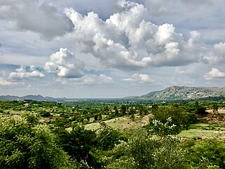
Kanakapura is a city in the Ramanagara district of Karnataka on the banks of the Arkavathi river and the administrative center of the taluk of the same name. Its founder is Shrihan Kanaka Sigmanath, hence its name. Kanakapura is largest cocoon silk producer in India. River Cauvery flows around 21 km in Kanakapura Taluk.Previously belonged to Bangalore Rural District. It was formerly the largest constituency in the country. (1,553 km2 [600 sq mi]). It is located among the lush green forests of the state of Karnataka. The town is infamous with the traffic of Kanakpura Road in Benglaluru, one of the most narrow and traffic-prone roads of the state. The town is a tourism hotspot and an often visited tourist favorite in the entire state of Karnataka, as it has something for everyone ranging from avid trekkers to history buffs and wildlife enthusiasts. The forest area in this taluk is very wide and about half of the Bannerghatta National Park is located in our Kanakapura area. Kodihalli wildlife range and harohalli wildlife range its division. The Kaveri Wildlife Sanctuary consists of two main zones namely the Sangam Wildlife range, the Muggur Wildlife range.

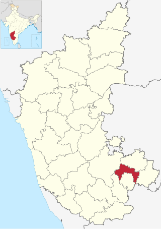
Ramanagara District is one of the 31 districts of Karnataka state in southern India. Ramanagara City is the administrative headquarters of this district. The district is part of Bangalore Division.

Halaguru or Halagur is a town in the southern state of Karnataka, India.
Harohalli is a Town in the southern state of Karnataka, India. It is the headquarter of Harohalli taluk of Bengaluru South district in Karnataka.

Huliyurdurga is a village in the state of Karnataka, India. It is located in the Kunigal taluk of Tumakuru district of Karnataka.
Kodihalli is a village in the southern state of Karnataka, India. It is located in the Kanakapura taluk of Ramanagara district in Karnataka. It is 17 km from Taluk headquarters Kanakapura and 45 km from district headquarters Ramanagara.
Kudur is a place in the southern state of Karnataka, India. It is located in the Magadi taluk of Ramanagara district in Karnataka. It is 21 km from Magadi, 56 km from Ramanagara and 30 km from Tumakuru.
Abbanakuppe is a village in the southern state of Karnataka, India. It is located in the Gubbi taluk of Tumkur district.
Abbur is a small village in the southern state of Karnataka, India. It is located in the Channapatna taluk of Ramanagara district in Karnataka.
Achalu (Kanakapura) is a village in the southern state of Karnataka, India. It is located in the Kanakapura taluk of Ramanagara district.

Adarangi is a village in the southern state of Karnataka, India. It is located in the Magadi taluk of Ramanagara.
Agrahara Valagerehalli is a village in the southern state of Karnataka, India. It is located in the Channapatna taluk of Ramanagara district in Karnataka.
Akkur, Channapatna is a village in the southern state of Karnataka, India. It is located in the Channapatna taluk of Ramanagara district.
Akkur is a village in the southern state of Karnataka, India. It is located in the Ramanagara taluk of Ramanagara district - 562159.
Sathanur may refer to several places in India:
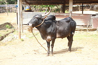
Hallikar is a breed of cattle native to the state of Karnataka, India. It derives its name from the Hallikar community traditionally known for their cattle rearing. It is commonly found in the traditional Hallikar belt of Mysore, Mandya, Kolar, Hassan, Banglore rural and Tumkur districts of South Karnataka.
Sathanur is a village in Ramanagara district of Karnataka, India. It is located around 70 km from the city of Bengaluru. The Bengaluru - Coimbatore National Highway 948 passes via this town.It is 18 km from Kanakapura and 27 km from Channapatna.
Mayasandra is a medium size village located in Ramanagara District, approximately 15 km from Shivagange. Mayasandra is surrounded by places including Beechanahalli, Sankighatta, Sugganahalli, Kudur, etc. When Ramanagara was carved out of Bangalore Rural in 2007, being part of Magadi taluk, Mayasandra became part of Ramanagara.

