The Birdwatchers' Field Club of Bangalore is a birdwatching club in Bangalore founded in the 1970s.

Whitefield is a suburb of Bangalore in the state of Karnataka, India. Established in 1882 as a settlement for the Eurasians and Anglo Indians of Bangalore, Whitefield remained a quaint little settlement at the eastern periphery of Bangalore city till the late 1990s when the local IT boom turned it into a major suburb. It is now a major part of Greater Bangalore. Whitefield is Bengaluru's first tech corridor to be connected by Namma Metro.

Kempe Gowda I locally venerated as Nadaprabhu Kempe Gowda, or commonly known as Kempe Gowda, was a governor under the Vijayanagara Empire in early-modern India. He is famous for the development of Bangalore Town in the 16th century. Kempegowda erected many Kannada inscriptions across the region.

Basaveshwaranagara, also known as Basaveshwaranagar, Basaveshnagara or Basaveshnagar is a largely residential neighbourhood in the west of Bengaluru, Karnataka, India. It is located to the west of Rajajinagara and is sandwiched between the localities of Mahalakshmi Layout to the north and Vijayanagara to the south, spread across multiple sub-localities, three assembly constituencies and seven Bruhat Bengaluru Mahanagara Palike (BBMP) wards. The area of Basaveshwaranagara is often considered West of Chord Road as it lies to the west of Chord Road, an arterial road in the western part of Bengaluru.

The Bangalore Development Authority (BDA) of Bangalore, India, is a governmental organization and the principal planning authority for Bangalore in accordance with the Karnataka Municipal Corporation Act. Its functions, carried out under the Karnataka Town and Country Planning Act of 1961, include preparing a Comprehensive Development Plan for the Bangalore Metropolitan Region. It also oversees planning and development of infrastructure, provision of development-related sites and services, the housing needs of underprivileged citizens in Bangalore and is currently the city's largest land developer. No other authority or person may undertake development within the Bangalore Metropolitan Region without the permission of the BDA.

HSR Layout, an abbreviation of Hosur Sarjapura Road Layout is a prominent suburb of South-Eastern Bangalore, India. The locality, initially developed by the Bangalore Development Authority in 1985 has now emerged into a coveted residential area due to its proximity to Electronic City, Sarjapur Road and the Outer Ring road on which I.T. Parks and other Special Economic Zones are located. It lies in the Bommanahalli constituency of the Karnataka State Assembly.

Yelahanka is a premium locality in north Bangalore and also a Taluk of Bangalore Urban district in the Indian state of Karnataka. One of the zones of BBMP. It is the oldest part of present Municipal Bengaluru (Bangalore) city and the northern end of the city. It is Nadaprabhu Kempegowda I, of the Yelahanka Prabhu clans, who laid the foundation of present-day Bengaluru through the creation of a "mud fort town" in 1537 CE

Bruhat Bengaluru Mahanagara Palike (BBMP) is the administrative body responsible for civic amenities and some infrastructural assets of the Greater Bengaluru metropolitan area. It is the fourth largest Municipal Corporation in India and is responsible for a population of 8.4 million in an area of 741 km2. Its boundaries have expanded more than 10 times over the last six decades.
Bangalore is the capital and the largest city of the Indian state of Karnataka. It is India's third largest city and fifth largest metropolitan area. Modern Bengaluru was founded in 1537 CE by Kempe Gowda, a vassal of the Vijayanagara Empire. Kempe Gowda built a mud fort in the vicinity of modern Bengaluru. By 1831, the city was incorporated into the British Raj with the establishment of the Bangalore Cantonment. The British returned dominion of the city to the King of Mysore, choosing however, to retain jurisdiction over the cantonment. Therefore, Bengaluru essentially became a twin city, with civic and infrastructural developments of the cantonment conforming to European styles of planning.
Arekere is a residential area on Bannerghatta Road in South Bangalore. The name Arekere originates from a water reservoir in the area.
Puttenahalli WS Lake also spelled as Puttanahalli Lake is a 10-hectare water body near Yelahanka, 14 km north of Bangalore.
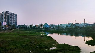
Lakes and tanks in the metropolitan area of Greater Bangalore and the district of Bangalore Urban are reservoirs of varying sizes constructed over a number of centuries by various empires and dynasties for rainwater harvesting. Historically, these reservoirs were primarily either irrigation tanks or for the water supply, with secondary uses such as bathing and washing. The need for creating and sustaining these man-made dammed freshwater reservoirs was created by the absence of a major river nearby coupled with a growing settlement. As Bangalore grew from a small settlement into a city, both of the primary historical uses of the tanks changed. Agricultural land witnessed urbanization and alternate sources of water were provisioned, such as through borewells, piped reservoir water and later river water from further away.
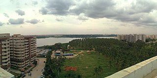
Bellandur Lake is located in the suburb of Bellandur in the southeast of the city of Bengaluru. It is the largest lake in the city. It is a part of Bellandur drainage system that drains the southern and the south-eastern parts of the city. The lake is a receptor from three chains of lakes upstream, and has a catchment area of about 148 square kilometres. Water from this lake flows further east to the Varthur Lake, from where it flows down the plateau and eventually into the Pinakani river basin.
Yelahanka Lake is a water body near Yelahanka, a suburb of Bangalore.
Bellandur is a suburb in south-east Bangalore, Karnataka, India. It is bounded by HSR Layout to the west, Devarabisanahalli to the east, Sarjapur Road to the south, and the Bellandur Lake to the north. The Bellandur Lake is the largest lake in Bangalore, and separates Bellandur from the HAL Airport. The Outer Ring Road passes through Bellandur, making the area an important transit point between east and south Bangalore.

Sarakki lake is a lake in the southern part of Bengaluru, India, in the suburb of the J. P. Nagar. It is one of the largest lakes in Bangalore and located on Puttenahalli main road. Sarakki is a portmanteau of the native Kannada language words, Saavira Hakki, which translates to "a thousand birds".

Ramamurthy Nagar ( ) is an area in Bangalore in the Indian state of Karnataka. It is located in the eastern part of Bangalore and comes under the E3 subdivision of BBMP. It is a rapidly growing suburb, adjacent to other areas such as Banaswadi, CV Raman Nagar and Krishnarajapuram, also officially called Krishnarajapura.
Puttenahalli lake is a small, restored freshwater lake located in JP Nagar 7th Phase, South Bangalore. The area of the lake is about 13 acres. The primary water sources are rain and surface water diverted to the lake through channels. The lake is currently maintained by Puttenahalli Neighbourhood Lake Improvement Trust (PNLIT) . The lake was on the brink of extinction, but due to the efforts of PNLIT, is now a haven for bird-watchers and on its way to being completely restored.

Bengaluru, formerly called Bangalore, is the capital and largest city of the southern Indian state of Karnataka. It has a population of more than 8 million and a metropolitan population of around 15 million, making it India's third most populous city and fourth most populous urban agglomeration. It is the most populous city and largest urban agglomeration in South India, and is the 27th largest city in the world. Located on the Deccan Plateau, at a height of over 900 m (3,000 ft) above sea level, Bengaluru has a pleasant climate throughout the year, with its parks and green spaces earning it the reputation of India's "Garden City". Its elevation is the highest of India's major cities.

Yelachenahalli is an elevated metro station on the North-South corridor of the Green Line of Namma Metro located on Kanakapura Road between Yelechenahalli and Konanakunte suburbs in Bangalore, India. It was opened to the public on 18 June 2017.

