Domlur is a small township located in the eastern part of Bangalore city in India. Domlur was included in the erstwhile Bangalore Civil and Military Station under the British Madras Presidency till it was transferred to the Mysore State in 1949.

Koramangala is a southeastern neighbourhood of the Indian city of Bengaluru. One of the largest in that metropolis, it is a residential locality with wide, tree-lined boulevards and a mix of commercial structures and bungalows. Planned as a suburb post-independence, its location between Bengaluru and Electronic City attracted migrants from across the country during Bengaluru's tech boom of the late 1990s. Consequently, it has gradually developed into a commercial centre and a prominent startup hub known for its high land prices and high-end shopping options. As of 2024, Koramangala has a population density of over 22,000 people per km².
The Outer Ring Road (ORR), officially renamed as ಡಾ.ಪುನೀತ್ ರಾಜ್ಕುಮಾರ್ ವರ್ತುಲ ರಸ್ತೆ (Dr. Puneeth Rajkumar Vartula Raste), is a ring road that runs around most of the perimeter of the city of Bangalore, Karnataka, India. This 60-kilometre-long (37 mi) road was developed by the Bangalore Development Authority and different sections were opened progressively between 1996 and 2002. IT firms on the Outer Ring Road generate revenue of US$ 22 billion every year, accounting for 32% of Bengaluru’s total IT revenue.
Indiranagar, is an affluent, mid-sized neighbourhood in east Bangalore, Karnataka, India. Indiranagar is one of the most expensive cosmopolitan neighbourhoods in Bangalore.
Velachery is a neighborhood of Chennai. It is located in the southern part of the Chennai city sharing borders with Guindy in the north, Taramani in the east, Perungudi in the south-east, Pallikaranai in the south, Madipakkam in south-west, Adambakkam in the west and north-west. It is the headquarters of Velachery taluk and straddles the boundary between Chennai and Kancheepuram districts.

The Bangalore Development Authority (BDA) of Bangalore, India, is a governmental organization and the principal planning authority for Bangalore in accordance with the Karnataka Municipal Corporation Act. Its functions, carried out under the Karnataka Town and Country Planning Act of 1961, include preparing a Comprehensive Development Plan for the Bangalore Metropolitan Region. It also oversees planning and development of infrastructure, provision of development-related sites and services, the housing needs of underprivileged citizens in Bangalore and is currently the city's largest land developer. No other authority or person may undertake development within the Bangalore Metropolitan Region without the permission of the BDA.
Bengaluru is the capital and the largest city of the Indian state of Karnataka. It is India's third largest city and fifth largest metropolitan area. Modern Bengaluru was founded in 1537 CE by Kempe Gowda, a vassal of the Vijayanagara Empire. Kempe Gowda built a mud fort in the vicinity of modern Bengaluru. By 1831, the city was incorporated into the British Raj with the establishment of the Bangalore Cantonment. The British returned dominion of the city to the King of Mysore, choosing however, to retain jurisdiction over the cantonment. Therefore, Bengaluru essentially became a twin city, with civic and infrastructural developments of the cantonment conforming to European styles of planning.

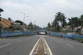
Dr S. K. Karim Khan Road, commonly known as 100 Feet Road Indira Nagar. It is a road in the Indian city of Bangalore that links Old Madras Road with Old Airport Road.

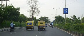
Old Airport Road is a major road in Bangalore, India. It was renamed from Airport Road after the new Bengaluru International Airport was opened at Devanahalli. Madivala Machideva Road is a 17 km stretch road which begins from the junction of Trinity Church Road and Victoria Road and goes to HAL Bangalore International Airport, Marathahalli, Varthur. Beyond that, the road officially becomes Varthur Road, but since the real estate boom started around 2003, builders have started calling the stretch between the Airport and the Marathahalli Outer Ring Road as Old Airport Road. Even so, due to the high significance of this road it has achieved due to its high accessibility for reaching Whitefield.

The Hyderabad Outer Ring Road, officially known as Nehru Outer Ring Road and abbreviated as, H.O.R.R., is a 158-kilometre (98 mi), eight-lane ring road expressway encircling Hyderabad, capital of the Indian state of Telangana. The expressway was designed for speeds up to 100 kilometres per hour (62 mph), later increased to 120 kilometres per hour (75 mph). A large part, 124 kilometres (77 mi) of the 158 kilometres (98 mi) was opened by December 2012.
Bangalore BRTS was a proposed bus rapid transit system in Bangalore, Karnataka. Beginning with a comprehensive report in 2007, and even earlier, several proposals were made to implement a BRTS in Bangalore.
Located in South Bangalore, Karnataka, India, Kumaraswamy Layout is a sub locality in Banashankari.
The Padi Lucas Junction is the intersection of NH 205 and Inner Ring Road in the city of Chennai and is one of the most important junctions in the city. It is located in Anna Nagar north of Koyambedu Junction. An elevated rotary has been constructed at this junction as part of the NHDP by NHAI to ease the traffic congestion. It was built at a cost of ₹ 1,300 million and was opened for traffic on 20 February 2009.

The central business district of Bangalore is the area within a 6 km radius around Vidhan Soudha. This is the center of Bangalore and was founded by Kempegowda of the Vijayanagara Empire. Most of the land is used by commercial establishments and the Indian Army with plans of skyscrapers under works. It has multiple high-rises including World Trade Center Bangalore and UB Tower. It also includes heritage properties like the Bangalore Fort and the Bangalore Pete.

The Inner Ring Road (IRR), also known as Jawaharlal Nehru Salai or 100-Feet road or State Highway 2, is a major transportation corridor encircling the city of Chennai. It was developed by the Chennai Metropolitan Development Authority (CMDA). It is 25.2 km long with three distinct arms viz., Northern arm, Central arm and Southern arm, connecting SH 49A in Tiruvanmiyur, Velachery main road at Vijayanagar, NH 32 at Kathipara, NH 4 at Koyambedu, NH 205 at Padi, NH 5 at Madhavaram and joining SH 104 at Manali.

Tiruchirappalli has a well-developed transport infrastructure. Being located almost at the geographic centre of the state Tamil Nadu India, Tiruchirappalli is well connected by Road, Rail and Air with most cities.
Kodihalli is a locality in the eastern part of Bangalore. It starts from 80 feet Indiranagar, Jeevanbhima Nagar junction and extends up to Leela Palace on Old Airport Road. Until the late 90s, Kodihalli was just a nondescript village on the way to HAL Airport, but since4 then it has seen extraordinary real estate growth of this area owing to its proximity to offices on Old Airport Road. It is surrounded by well established areas like Thippasandra, Indiranagar and Domlur. It is about 4 km from M.G road. Nearest Railway Station is at Krishnarajapuram about 7 km.
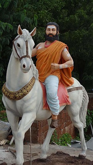
Madivala Machideva, also known as Veera Ganachari Madivala Machideva, was an Indian warrior of the 12th-century.

Ramamurthy Nagar ( ) is an area in Bangalore in the Indian state of Karnataka. It is located in the eastern part of Bangalore and comes under the E3 subdivision of BBMP. It is a rapidly growing suburb, adjacent to other areas such as Banaswadi, CV Raman Nagar and Krishnarajapuram, also officially called Krishnarajapura.