Mahalakshmi Layout Mahalakshmipura | |
---|---|
neighborhood | |
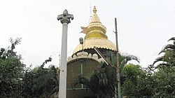
Nickname: Temple Layout | |
Coordinates: 13°01′00″N77°32′18″E / 13.01667°N 77.53833°E Coordinates: 13°01′00″N77°32′18″E / 13.01667°N 77.53833°E | |
Country | India |
State | Karnataka |
District | Bengaluru Urban |
Metro | Bengaluru |
Area | |
• Total | 1.46756 km2 (0.56663 sq mi) |
Languages | |
• Official | Kannada |
Time zone | UTC+5:30 (IST) |
PIN | 560086 |
Telephone code | 080 |
Vehicle registration | KA 02 |
Mahalakshmi Layout, also known as Mahalakshmipura is a neighborhood in northwest Bengaluru, India. It is near Rajajinagara, Basaveshwaranagara and Yeshwanthpura. Together with Nandini Layout, Kurubarahalli and Nagapura, it is one of the biggest residential areas in Bengaluru.
Mahalakshmi layout has a considerable number of educational institutions, both at the primary/secondary education and higher education level.
The area consists of renowned colleges and colleges.
Bristol Grammar School (BGS) is a 4–18 mixed, private day school in Bristol, England. It was founded in 1532 by Royal Charter for the teaching of 'good manners and literature', endowed by wealthy Bristol merchants Robert and Nicholas Thorne. The school flourished in the early 20th century under headmaster Sir Cyril Norwood (1906–1916), embodying "the ideals and experiences of a leading public school". Norwood went on to serve as the master at Marlborough College and Harrow, and as president of St John's College, Oxford.
Basaveshwaranagara is a largely residential neighbourhood in the west of Bengaluru, Karnataka, India. It is located to the west of Rajajinagara and is sandwiched between the localities of Mahalakshmi Layout to the north and Vijayanagara to the south, spread across multiple sub-localities, three assembly constituencies and seven Bruhat Bengaluru Mahanagara Palike (BBMP) wards. The area of Basaveshwaranagara is often considered West of Chord Road as it lies to the west of Chord Road, an arterial road in the western part of Bengaluru.
Indiranagar is a medium-sized neighbourhood in east Bangalore, Karnataka, India. A cosmopolitan locality, Indiranagar is one of the most expensive neighbourhoods in Bangalore.
The Bangalore Development Authority (BDA) of Bangalore, India, is a governmental organization and the principal planning authority for Bangalore. Its function, under the Karnataka Town and Country Planning Act of 1961, is as a regulatory body required "to prepare in the prescribed manner a Comprehensive Development Plan" for the Bangalore Metropolitan Region. It also oversees planning and development of infrastructure, provision of development-related sites and services, the housing needs of underprivileged citizens in Bangalore and is currently the city's largest land developer. No other authority or person may undertake development within the Bangalore Metropolitan Region without the permission of the BDA.
HSR Layout, an abbreviation of Hosur Sarjapura Road Layout is a prominent suburb of South-Eastern Bangalore, India. The locality, initially developed by the Bangalore Development Authority in 1985 has now emerged into a coveted residential area due to its proximity to Electronic City, Sarjapur Road and the Outer Ring road on which I.T. Parks and other Special Economic Zones are located. It lies in the Bommanahalli constituency of the Karnataka State Assembly.
Yelahanka is a suburb of Bangalore in the Indian state of Karnataka and one of the zones of BBMP. It is the oldest part of present Municipal Bengaluru (Bangalore) city and is in the north of the city. It is Nadaprabhu Kempegowda I, of the Yelahanka Prabhu clans, who laid the foundation of present-day Bengaluru through the creation of a "mud fort town" in 1537 CE
Hulimavu is a locality in the south of Bangalore under the Bommanahalli Zone of Bruhat Bengaluru Mahanagara Palike (BBMP).
Arekere is a residential area on Bannerghatta Road in South Bangalore. The name Arekere originates from a water reservoir in the area.
Vijayanagar, officially Vijayanagara is a locality in west Bangalore, India. It derives its name from the Vijayanagara empire that flourished in South India during the 15th and 16th centuries. It is bound by Mysore Road and Magadi Road, with Chord Road cutting through. It is the northernmost area in South Bangalore.
Rajajinagara, also known as Rajajinagar is a residential neighborhood and business hub in the west of Bangalore. It is one of the zones of BBMP. It is bordered by Basaveshwaranagara, Malleshwara, Mahalakshmipura alias West of Chord road second stage, Mahalakshmi Layout, Vijayanagara and Rajajinagara Industrial Suburb. It serves as a centre place to all in Bengaluru.
Jalahalli is a suburb in northern part of Bengaluru is one of the greenest areas of Bengaluru. It is mainly divided into Jalahalli East and Jalahalli West. Gangamma Circle is the junction between the roads connecting Jalahalli East, Jalahalli West, Jalahalli Village, and Jalahalli Cross. The National Academy of Customs and Narcotics in Bengaluru is located here.
Rabindranath Tagore Nagar or simply R. T. Nagar is an area in Bangalore, India. It is situated in the northern part of the city. It is named after Rabindranath Tagore. It is part of the Bangalore North Lok Sabha Constituency and the Hebbal Assembly Constituency. R.T Nagar has two blocks, Block I and Block II. It became popular after the construction of the new airport at Devanahalli
BTM Layout, an abbreviation of Bommanahalli, Tavarekere and Madiwala Layout is a locality in Bengaluru, Karnataka, India.
Padmanabhanagar is a posh residential locality in South Bangalore, India, covering an area of 1.68 km2 It's one of the zones of BBMP. Padmanabhanagar has a very famous park called Lakshmikanta Park. This park houses Lakshmi Kantha temple. It was looked after by residents association, in 2018 the corporator allotted funds and developed it further. The park was eyed for its medicinal trees and was sanctioned to be cut down completely and set up a landscaped area but the senior citizens of the locality who nurtured the park protested and stopped it. It is surrounded by Kumaraswamy Layout, Gowdanapalya, Chennamanakere, Kathriguppe, Kadirenahalli, Uttarahalli and Chikkakalasandra.
Shri Balagangadharanatha Swamiji was an Indian religious leader who was the seer of Adichunchanagiri, Nagamangala Taluk, Mandya district. He was awarded Padma Bhushan, India's third highest civilian honour for the year 2010.
Rajarajeshwari Nagar, officially Rajarajeshwari Nagara is a residential neighborhood in Bangalore, Karnataka, India. It is located in the southwestern part of Bangalore along the Mysore Road, with Nagarbhavi and the Bangalore University to the north and north west and Kengeri to the south west. There is a prominent arch shaped structure on Mysore Road which serves as the most popular entrance to this locality.
Shree Ananthnagara is a locality situated in the south of Bengaluru. It is about 3 km from the Electronic City Phase 2 and about 11 km from the Central Silk Board, and occupies a space of 800-acres.
CMR University is a private university located in Bangalore, Karnataka, India. CMR University (CMRU) has been established and is governed by the CMR University Act of 2013. CMRU aims to promote and undertake the advancement of university education in law, technical, health, management, life sciences and other allied sectors of higher and professional education. CMR University is also recognized by AIU.
Mahalakshmi Layout Assembly Constituency is one of the 224 legislative assembly segments of the state of Karnataka. It is a part of Bengaluru Urban district and comes under the Bengaluru North parliamentary constituency.
The 1996 Bangalore Mahanagara Palike election was held in October 1996 in all 100 Wards of Bangalore