
Sankey tank, a manmade lake or tank, is situated in the western part of Bangalore in the middle of the neighbourhoods of Malleshwaram, Vyalikaval and Sadashivanagar. The lake covers an area of about 15 ha. At its widest, the tank has a width of 800 m (2,624.7 ft).

Namma Metro, also known as Bengaluru Metro, is a rapid transit system serving the city of Bengaluru, the capital city of the state of Karnataka, India. It is the second-longest operational metro network in India with an operational length of 73.75 kilometers, just behind Delhi Metro. Upon its inauguration in 2011, it became the first underground metro system in South India. Namma Metro has a mix of underground, at grade, and elevated stations. Out of the 66 operational metro stations of Namma Metro as of October 2023, there are 57 elevated stations, eight underground stations and one at-grade station. The system runs on standard-gauge tracks.
Bangalore is situated in the southeast of the South Indian state of Karnataka. It is positioned at 12.97° N 77.56° E and covers an area of 2,190 square kilometres (850 sq mi). A landlocked city, Bangalore is located in the heart of the Mysore Plateau at an average elevation of 920 metres (3,020 ft). Bangalore district borders with Kolar and Chikkaballapur in the northeast, Tumkur in the northwest, and Mandya and Ramanagaram in the southeast.

Jakkur Aerodrome is an airport located in Jakkur, a suburb of Bangalore, Karnataka, India. It is the only dedicated general aviation field in Bangalore. The airfield is the site of the Government Flying Training School (GFTS), the only flying school in the state.

Vibuthipura Lake is a lake in the suburb of Hindustan Aeronautics Limited, in the southeast of the city of Bengaluru. The lake is the part of Bellandur-Varthur Lake series.
Puttenahalli WS Lake also spelled as Puttanahalli Lake is a 10-hectare water body near Yelahanka, 14 km north of Bangalore.

Madiwala lake is one of the biggest lakes in Bangalore, India spread over an area of 114.3 hectare. The water in the lake was fit for drinking till the early 1990s. Since then it has become unfit for drinking due to industrial waste and sewage entering the waterbody. It has gradually become polluted.
Lakes and tanks in the metropolitan area of Greater Bangalore and the district of Bangalore Urban are reservoirs of varying sizes constructed over a number of centuries by various empires and dynasties for rainwater harvesting. Historically, these reservoirs were primarily either irrigation tanks or for the water supply, with secondary uses such as bathing and washing. The need for creating and sustaining these man-made dammed freshwater reservoirs was created by the absence of a major river nearby coupled with a growing settlement. As Bangalore grew from a small settlement into a city, both of the primary historical uses of the tanks changed. Agricultural land witnessed urbanization and alternate sources of water were provisioned, such as through borewells, piped reservoir water and later river water from further away.
Bellandur Lake is located in the suburb of Bellandur in the southeast of the city of Bengaluru. It is the largest lake in the city. It is a part of Bellandur drainage system that drains the southern and the south-eastern parts of the city. The lake is a receptor from three chains of lakes upstream, and has a catchment area of about 148 square kilometres. Water from this lake flows further east to the Varthur Lake, from where it flows down the plateau and eventually into the Pinakani river basin.

Agara lake is an 80-acre lake located in Agara, Bangalore. It is part of the Varthur lake series. Madiwala Lake is upstream while Bellandur Lake is downstream. Inter-lake connections have seen fragmentation and urbanisation.
Yelahanka Lake is a water body near Yelahanka, a suburb of Bangalore.

Bangalore, officially Bengaluru, is the capital and largest city of the southern Indian state of Karnataka. It has a population of more than 8 million and a metropolitan population of around 15 million, making it India's third most populous city and fourth most populous urban agglomeration. It is the most populous city and largest urban agglomeration in South India, and is the 27th largest city in the world. Located on the Deccan Plateau, at a height of over 900 m (3,000 ft) above sea level, Bangalore has a pleasant climate throughout the year, with its parks and green spaces earning it the reputation of India's "Garden City". Its elevation is the highest of India's major cities.

Manyata Embassy Business Park is a software technology park in Bangalore, Karnataka, India. The park is situated in Nagawara on Outer Ring Road, and has a building area of 9.8 million square feet. The park is spread over 300 acres.

NAL Wind Tunnel Road, expanded as National Aerospace Laboratories Wind Tunnel Road, is a road in the Murugeshpalya locality of Bengaluru. It was called Challaghatta Road, a name that still persists in local use, before it was renamed. It links HAL Airport Road with Bellandur. HAL Airport Road branches into Wind Tunnel Road at a traffic light junction.

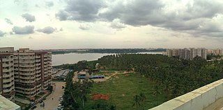
Jakkur Lake is among the biggest lakes in Bangalore, and is located on the northern side of the city. It derives its name from the name of the locality, Jakkur. It is spread around 35 ha and has several islands.

Yele Mallappa Shetty Lake is one of the largest lakes in Bangalore, located on the eastern side of the city, outside of KR Puram. It is an artificial water reservoir constructed in early 1900s. The lake is spread over 490 acres (198.3 ha).
The Blue Line or ORR-Airport Metro Line is part of the Namma Metro rail network for the city of Bangalore, Karnataka, India. It consists of two sections - Phase-2A and Phase-2B. Construction of Phase-2A began in August 2021. Construction of Phase-2B began in February 2022. The 58.19 km line connects Central Silk Board with the Kempegowda International Airport. The Line is mostly elevated but also has an at-grade (surface) section close to the Airport and 2 short underground sections where it passes the Jakkur Aerodrome and Yelahanka AFB. There are 30 stations on the line of which the two station/s at the Airport may be at surface level or underground. Blue Line will have interchanges with the Yellow Line at Central Silk Board, Purple Line at KR Pura, Pink Line at Nagawara and with the future /proposed Orange Line at Hebbal.
Rachenahalli Lake is a lake in Bangalore, India. It is located in Thanisandra in North Bangalore. It is about 1.4km from Amruthahalli police station.
Jakkur is a suburb in the northern part of Bangalore, Karnataka, India. Located on the eastern side of the National Highway 44 between Yelahanka and Hebbal. Primarily a residential locality the area is also known for the Jakkur Aerodrome ,Jakkur lake, and Jawaharlal Nehru Centre for Advanced Scientific Research. Jakkur Aerodrome spread over 200 acres, opened in 1948 is now a pilot training school.

