
Accrington is a town in the Hyndburn borough of Lancashire, England. It lies about 4 miles (6 km) east of Blackburn, 6 miles (10 km) west of Burnley, 13 miles (21 km) east of Preston, 20 miles (32 km) north of Manchester and is situated on the culverted River Hyndburn. Commonly abbreviated by locals to "Accy", the town has a population of 35,456 according to the 2011 census. Accrington is the largest settlement and the seat of the Hyndburn borough council.

Utrecht is the fourth-largest city of the Netherlands, as well as the capital and the most populous city of the province of Utrecht. The municipality of Utrecht is located in the eastern part of the Randstad conurbation, in the very centre of mainland Netherlands, and includes Haarzuilens, Vleuten and De Meern. It has a population of 361,699 as of December 2021.

Luton is a town and borough in Bedfordshire, England. The borough had a population of 225,262 at the 2021 census.

Northampton is a town and civil parish in the West Northamptonshire unitary authority area of Northamptonshire, England. It is the county town of Northamptonshire and the administrative centre of the unitary authority of West Northamptonshire. The town is situated on the River Nene, 60 miles (97 km) north-west of London and 50 miles (80 km) south-east of Birmingham. Northampton is one of the largest towns in England; the population of its overall urban area was recorded as 249,093 in the 2021 census. The parish of Northampton alone had 137,387.

Kentish Town is an area of northwest London, England, in the London Borough of Camden, immediately north of Camden Town, close to Hampstead Heath.

Camden Town is an area in the London Borough of Camden, around 2.5 miles (4 km) north-northwest of Charing Cross. Historically in Middlesex, it is identified in the London Plan as one of 34 major centres in Greater London.

Crewe is a railway town and civil parish in the unitary authority of Cheshire East in Cheshire, England. The civil parish of Crewe had a population of 55,318 in the 2021 census. The larger Crewe built-up area, which also covers parts of the adjacent civil parishes of Willaston, Shavington cum Gresty and Wistaston, had a total population of 76,437 in 2021.

Acton Town is a London Underground station in the south-west corner of Acton, West London, in the London Borough of Ealing, close to its boundary with the London Borough of Hounslow. The station is served by the District and Piccadilly lines and is in Travelcard Zone 3. On the District line, it is between Chiswick Park and Ealing Common stations, and on the Piccadilly line it is between Hammersmith and Ealing Common on the Uxbridge branch & South Ealing on the Heathrow branch. Acton Town station was opened as Mill Hill Park on 1 July 1879 by the District Railway. It remained as a terminus until on 1 May 1883 and 23 June 1903 the District Railway opened two branches from Acton Town to Hounslow Town and Park Royal & Twyford Abbey respectively. On 4 July 1932 the Piccadilly line was extended to Acton Town. District line services to both the Hounslow and Uxbridge branches were withdrawn completely on 9 and 10 October 1964 after which operations were provided by the Piccadilly line alone.

New Jalpaiguri Junction railway station established in 1960, is an A1 category broad-gauge and narrow-gauge railway station under Katihar railway division of Northeast Frontier Railway zone. It is the largest and the busiest railway junction of northern Bengal. This junction is largest among the railway stations which serve the city of Siliguri, the largest metropolis of the North Bengal. The other stations are- Siliguri Junction, Gulma, Bagdogra, Matigara, Rangapani and Siliguri Town. New Jalpaiguri junction ranked 10th cleanest railway station in India in 2016 survey and came among the top 100 booking stations of Indian railway. New Jalpaiguri, as a railway station serves as the entry point to North Bengal, Sikkim, other countries like Nepal, Bhutan, Bangladesh and the seven northeastern states. New Jalpaiguri Junction acts as a connecting base of railways for the northeastern states to the Indian mainland.

Bannerghatta Road is an Indian State Highway in Karnataka. It connects Bangalore with the towns of Bannerghatta, Jigani, and Anekal. It extends for 49 kilometres (30 mi). It starts as a branch from Hosur Road near the Adugodi Christian Cemetery and ends at Anekal.
Park Town is a neighbourhood in downtown Chennai, India. It lies adjacent to the historical neighbourhood of George Town. The area got its name from the People's Park which was situated near the Ripon Building. It was earlier known as White Town, as the Europeans used to stay here.

Cape Town railway station is the main railway station of the city of Cape Town, South Africa. It is located along Adderley and Strand Streets in the city's central business district.

WMRE is a sports radio formatted broadcast radio station licensed to Charles Town, West Virginia, serving Charles Town and Jefferson County, West Virginia. WMRE is owned and operated by iHeartMedia.

The central business district of Bengaluru is the area within a 6 km radius around Vidhan Soudha. This is the center of Bangalore and was founded by Kempegowda of the Vijayanagara Empire. Most of the land is used by commercial establishments and the Indian Army with plans of skyscrapers under works. It has multiple high-rises including World Trade Center Bangalore and UB Tower. It also includes heritage properties like the Bangalore Fort and the Bangalore Pete.

The London Borough of Camden is a borough in Inner London, England. Camden Town Hall, on Euston Road, lies 1.4 mi (2.3 km) north of Charing Cross. The borough was established on 1 April 1965 from the former metropolitan boroughs of Holborn, St Pancras and Hampstead.

Kadugodi is a suburb located in Whitefield, Bangalore in the state of Karnataka, India. The area is said to have been founded over 1000 years ago by the Chola dynasty.
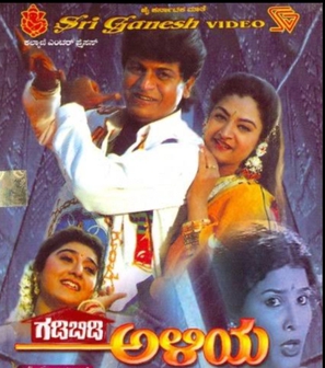
Gadibidi Aliya is a 1995 Indian Kannada-language comedy drama film, directed by Sai Prakash and produced by K. Raghava Rao. This film stars Shiva Rajkumar in a dual role, Malashri and Mohini whilst Jayamala and Srinath play other pivotal roles.
Rowdy Aliya is a 2004 Indian Kannada comedy - action film directed and written by Om Sai Prakash and produced by Neha. The film features Shiva Rajkumar and Priyanka Trivedi in the lead roles along with Jaimala and Chaya Singh in other pivotal roles.
The Pink Line of Namma Metro is under construction and will form part of the metro rail network for the city of Bangalore, Karnataka, India. The 21.25 km (13.20 mi) line connects Kalena Agrahara station on Bannerghatta Road in the south with Nagawara station on Outer Ring Road in the north. The Pink Line is mostly underground but also has a 6.98 km (4.34 mi) elevated section and a 0.48 km (0.30 mi) at-grade (surface) section. There are 18 stations on the line, including 12 underground and 6 elevated ones. Pink Line will have an interchange with the Purple Line at MG Road station. It will also have interchanges with the Yellow line at Jayadeva Hospital station and with the Blue Line at Nagawara. Both these lines are under construction.
Wilson Garden is a neighbourhood in the central part of Bangalore, India. It is surrounded by Richmond Town, Lal Bagh, Jayanagara, Basavanagudi, Kalasipalyam, Adugodi and Koramangala. Among the landmarks located in/near the locality are Atal Bihari Vajpayee TTMC, NIMHANS and Lakkasandra Lake.

