Domlur

Last updated

Domlur
Neighbourhood
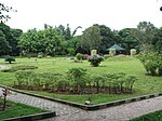
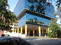
Domlur BusDepot.JPG
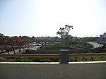
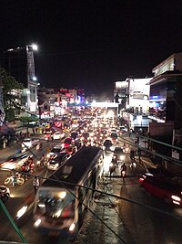
View from the Domlur 'Foot Over Bridge'.JPG
(Top to bottom) Domlur bus depot, View from Domlur foot over bridge
Bangalore street Map.png
Red pog.svg
Domlur
Location in Bengaluru, India
Coordinates: 12°57′39″N77°38′10″E / 12.9608157°N 77.6361322°E / 12.9608157; 77.6361322
CountryFlag of India.svg  India
State Karnataka
District Bengaluru Urban
MetroBengaluru
ZoneJayanagar
Ward112
Population
  Total34,703 [1]
Languages
  Official Kannada
Time zone UTC+5:30 (IST)
PIN
560071
Vehicle registration KA-03
Lok Sabha constituencyBangalore Central
Vidhan Sabha constituencyShantinagar [2]
Planning agency BDA

Domlur is a small township located in the eastern part of Bangalore city in India. Domlur was included in the erstwhile Bangalore Civil and Military Station [3] under the British Madras Presidency till it was transferred to the Mysore State in 1949. [4]

Contents

Domlur is surrounded by offices of multinational software companies and business process outsourcing companies. Domlur hosts the software park Embassy Golf Links (EGL). McAfee, NetApp, Dell, IBM, Microsoft, ANZ, Sasken, Target and Mistral Solutions are the companies located in this area. Domlur is located close to the 'old airport'.

The major military establishments having divisions in Domlur are Indian Air Force, EME Workshop, and ASC (Army Service Corps).

Ancient Tamil inscriptions

The Chokkanathaswamy Temple is a 10th-century Chola temple, located in Domlur. There are a number of Tamil inscriptions in the temple. Domlur is referred to as Tombalur or Desimanikkapattanam in these inscriptions. Chakravarthi Posalaviraramanatha Deva has left inscriptions with directions to temple authorities of his kingdom. Further, some inscriptions record the tributes, taxes and tolls made to the temple by Devaraya II of Vijayanagar Empire, which state the houses, wells, land around Tombalur were offered to the deity Sokkapperumal. Another Tamil inscription dated 1270 talks about 2 door posts being donated by Alagiyar. Yet another inscription in Tamil details Talaikkattu and his wife donating lands from Jalapalli village and Vinnamangalam tank to the deity. A 1290AD inscription talks about donation of ten pens from the revenue of Tommalur by Poysala vira Ramananda. [3] [5] [6] [7] [8] [9] [10]

Transport

Domlur is very well connected to all parts of Bangalore by road. There are three arterial roads in the locality- Old Airport Road, 100 Feet Road and Inner Ring Road- which connect Domlur to the rest of Bangalore city.

Domlur is easily accessible by the Bangalore Metropolitan Transport Corporation (BMTC) buses and has a sprawling bus terminus (known as Domlur Traffic Transit & Management Centre [TTMC]). The TTMC is located on the Old Airport Road and has parking facility for cars and two-wheelers. All buses from Kempegowda Bus Station, K. R. Market and Shivajinagar towards HAL, Marathahalli, Varthur and Whitefield as well as buses from Jeevanbhimanagar and Indiranagar towards Koramangala, BTM Layout, Jayanagar and Banashankari pass through Domlur.

The nearest Namma Metro station is at Indiranagar, which is around 2.5 km from Domlur.

Old Airport road flyover

A major landmark in Domlur is the Airport road flyover (also known as Domlur flyover) at the Old Airport Road, 100 Feet Road and Inner Ring Road junction. This flyover was notorious for its delay in construction and the traffic trouble caused by its delay which was due to the mismanagement by the subcontractor UPSBC ( Uttar Pradesh State Bridge Corporation). [11] The construction of the flyover which was started in early 2003 ended in 2007. The flyover, excluding the outer loops, was completed in July 2006 and opened to public on 12 July 2006. [12] Subsequently, the other loops were opened to public in the next eight months.

Civic Administration

Politics

Domlur is part of the Shantinagar legislative assembly constituency led by MLA N. A. Haris (INC). Shantinagar in turn comes under Bangalore Central parliamentary constituency led by MP P. C. Mohan (BJP). During the 2014 general election, P. C. Mohan won from Bangalore Central defeating his nearest rival Rizwan Arshad (INC) by a margin of 1,37,500 votes. [13] [14] N. A. Haris won the 2018 assembly election from Shantinagar by a margin of 18,205 votes defeating his nearest rival K. Vasudevamurthy (BJP). [15]

Civic Administration

Domlur is a ward under the Bruhat Bengaluru Mahanagara Palike (BBMP), which is the administrative body for Bangalore city and comes under the Jayanagar zone of the BBMP. The ward number is 112. The current corporator of Domlur ward is C. R. Lakshminarayan (Gundanna), who is politically an Independent. [16]

Post Office

Domlur post office is located at Domlur 1st Stage on the Service Road running parallel to the Old Airport Road. The pin code for the area is 560071.

Related Research Articles

<span class="mw-page-title-main">Madiwala</span> Suburb in Bangalore, Karnataka, India

Madiwala is a locality in southeastern Bangalore, India.

<span class="mw-page-title-main">Bruhat Bengaluru Mahanagara Palike</span> Administrative body for the city of Bengaluru

Bruhat Bengaluru Mahanagara Palike (BBMP) is the administrative body responsible for civic amenities and some infrastructural assets of the Greater Bengaluru metropolitan area. It is the fourth largest Municipal Corporation in India and is responsible for a population of 8.4 million in an area of 741 km2. Its boundaries have expanded more than 10 times over the last six decades.

<span class="mw-page-title-main">Padmanabhanagar</span> Neighbourhood in Bangalore Urban, Karnataka, India

Padmanabhanagar is a residential locality in South Bangalore, India, covering an area of 1.68 km2. It is one of the zones of BBMP. Padmanabhanagar has a very famous park called Lakshmikanta Park. This park houses Lakshmi Kantha temple. It was looked after by residents association, in 2018 the corporator allotted funds and developed it further. The park was eyed for its medicinal trees and was sanctioned to be cut down completely and set up a landscaped area but the senior citizens of the locality who nurtured the park protested and stopped it. It is surrounded by Kumaraswamy Layout, Gowdanapalya, Chennamanakere, Kathriguppe, Kadirenahalli, Uttarahalli and Chikkakalasandra.

Located in South Bangalore, Karnataka, India, Kumaraswamy Layout is a sub locality in Banashankari.

Kaggadasapura, also known as Upper Indiranagar is a relatively new area located near DRDO township in CV Raman Nagar, Bangalore, India. Kaggadasapura is an area in Bangalore, and has many apartment complexes. It is located at the coordinates: 12°59'0"N, 77°40'32"E. It is about 4 km from Indiranagar and old (HAL) Airport Road in Bangalore. Defence Avionics Research Establishment (DARE), Center for Artificial Intelligence Research (CAIR) and DRDO Phase II are located at Kaggadasapura.
<span class="mw-page-title-main">Bellandur</span> Suburb in Bangalore Urban, Karnataka, India

Bellandur is a suburb in south-east Bangalore, Karnataka, India. It is bounded by HSR Layout to the west, Devarabisanahalli to the east, Sarjapur Road to the south, and the Bellandur Lake to the north. The Bellandur Lake is the largest lake in Bangalore, and separates Bellandur from the HAL Airport. The Outer Ring Road passes through Bellandur, making the area an important transit point between east and south Bangalore.

<span class="mw-page-title-main">Inner Ring Road, Bangalore</span> First Ring Road in Bengaluru, serving as an arterial for bypassing major areas.

The Inner Ring Road is an arterial road in Bangalore, India. It is a six-lane link road connecting Indiranagar and Koramangala. The northern end of the road, beyond Old Airport Road from Domlur junction is called 100 Feet Road.

Brookefield is a neighbourhood of Bangalore. Established in the late 19th century as a settlement for the Eurasians of Bangalore. It is a wealthy area, with high real estate prices and relatively new commercial roads such as ITPL road.

Chokkanathaswamy temple, at Domlur in the Indian city of Bangalore, Karnataka, India, is dedicated to the deity known as Chokkanathaswamy or Chokka Perumal. It is one of the oldest temples in the city. The temple has numerous Kannada and Tamil inscriptions that have been documented in the Epigraphia Carnatica Vol 9, Bangalore District (1905ed). Based on these inscriptions the temple is at least as old as 1200 CE.

<span class="mw-page-title-main">Ramamurthy Nagar</span> Neighbourhood in Bangalore Urban, Karnataka, India

Ramamurthy Nagar ( ) is an area in Bangalore in the Indian state of Karnataka. It is located in the eastern part of Bangalore and comes under the E3 subdivision of BBMP. It is a rapidly growing suburb, adjacent to other areas such as Banaswadi, CV Raman Nagar and Krishnarajapuram, also officially called Krishnarajapura.

There are nearly a thousand inscriptions in Tamil in the Southern Karnataka districts of Bangalore, Mysore, Kolar and Mandya in India. Nearly one third of these inscriptions are found in the Kolar District. Of all the inscriptions collected and published in the Epigraphia Carnatica Vol X for Kolar district, a fourth are in Tamil. The Tamil inscriptions start to appear around 1000 AD, after the conquest of the region by the Chola dynasty king Rajaraja I. Even after the Cholas left the area, the Hoysala and later the Vijaynagar kingdoms continued to use Tamil in the inscriptions.

Gandhi Nagar is a locality situated in Bangalore. It is a bustling neighbourhood of Central Bangalore.

In 2007, for administrative purposes, the city of Bangalore was divided into nine zones, which were further subdivided into a total of 198 wards administered by the Bruhat Bengaluru Mahanagara Palike (BBMP). After delimitation in 2023, BBMP increased the number of wards to 225.

<span class="mw-page-title-main">Yelahanka Ward</span> Bruhat Bengaluru Mahanagara Palike Ward in Karnataka, India

Yelahanka Ward, officially known as Kempegowda Ward is one of the 225 Wards of Bruhat Bengaluru Mahanagara Palike, an administrative body responsible for civic amenities and some infrastructural assets of the Greater Bangalore metropolitan area in the Indian state of Karnataka.

<span class="mw-page-title-main">2010 Bruhat Bengaluru Mahanagara Palike election</span>

The 2010 Bruhat Bengaluru Mahanagara Palike election was held on 4 April 2010 in all 198 Wards of Bangalore

<span class="mw-page-title-main">2015 Bruhat Bengaluru Mahanagara Palike election</span> 2015 election in India

The 2015 Bruhat Bengaluru Mahanagara Palike election was held on 22 April 2015 in all 198 Wards of Bangalore (Bengaluru).
<span class="mw-page-title-main">Chowdeshwari Ward</span> Bruhat Bengaluru Mahanagara Palike Ward in Karnataka, India

Chowdeshwari Ward, is one of the 198 Wards of Bruhat Bengaluru Mahanagara Palike, an administrative body responsible for civic amenities and some infrastructural assets of the Greater Bangalore metropolitan area in the Indian state of Karnataka.

<span class="mw-page-title-main">Attur Ward</span> Bruhat Bengaluru Mahanagara Palike Ward in Karnataka, India

Attur Ward, is one of the 198 Wards of Bruhat Bengaluru Mahanagara Palike, an administrative body responsible for civic amenities and some infrastructural assets of the Greater Bangalore metropolitan area in the Indian state of Karnataka.

Vira Ramanatha was a king of the southern portion of the Hoysala Empire. In 1254 CE, Hoysala king Vira Someshwara divided his kingdom between his two sons, Narasimha III who ruled from Halebidu, their original capital, had got the greater part of the ancestral kingdom and Vira Ramanatha Deva obtained the remaining part consisting of the present Kolar district and the Tamil territories conquered by the Hoysalas in the south, and ruled from Kannanur Kuppam near Srirangam. Like his father Narasimha II, Someshwara stayed back at Kannanur with Ramanatha where he was killed in 1262/1263 CE in a war with Sadayavarman Sundara Pandyan I of the Pandya dynasty.
References

  1. "Bruhat Bengaluru Mahanagara Palika". Archived from the original on 1 June 2015.
  2. "Domlur" (PDF). BBMP. Retrieved 20 March 2018.
  3. 1 2 Rice, Benjamin Lewis (1887). Mysore: A Gazetteer Compiled for Government. London, UK: Asian Educational Services. p. 70. ISBN   8120609778 . Retrieved 17 January 2015.
  4. Srivatsa, Sharath S (31 October 2007). "Bangalore calling: it all goes way back…". The Hindu. No. Bangalore. Retrieved 3 January 2015.
  5. Githa, U B (19 April 2004). "A Chola temple in Domlur!". No. Bangalore. Deccan Herald. Archived from the original on 4 January 2015. Retrieved 4 January 2015.
  6. Githa, U B. "Chokkanathaswamy Temple, a fine example of Chola architecture". Chitralakshana: All about Indian Art. Archived from the original on 23 September 2015. Retrieved 17 January 2015.
  7. Sridhar, Lakshminarasimhan; Sridhar, Geetha. "Chokkanarayan Swamy Temple Domlur". Vishnu Temples of Karnataka. Archived from the original on 18 January 2015. Retrieved 16 January 2015.
  8. Rao, Priyanka S (19 May 2012). "Chokkanatha: The city's oldest temple". No. Bangalore. The New Indian Express. Archived from the original on 18 January 2015. Retrieved 18 January 2015.
  9. Harshitha, Samyuktha (10 December 2012). "The temple of the Cholas". Suttha Muttha. Retrieved 25 January 2015.
  10. Rizvi, Aliyeh (20 October 2014). "Good vibrations". No. Bangalore. Bangalore Mirror. Bangalore Mirror Bureau. Retrieved 6 February 2015.
  11. "Residents target delay in flyover - Times of India". The Times of India . Archived from the original on 6 February 2012. Retrieved 14 January 2022.
  12. "Airport Road flyover to be thrown open tomorrow". The Hindu. 11 July 2006 via www.thehindu.com.
  13. "Constituencywise-All Candidates". ECI. Archived from the original on 28 June 2014. Retrieved 1 July 2018.
  14. "Karnataka General Election 2009" (PDF). Election Commission of India. p. 88. Archived from the original (PDF) on 4 March 2016. Retrieved 1 July 2018.
  15. Despite Son’s Assault Case, Cong MLA NA Haris Wins a Third Time
  16. BBMP ELECTION – 2015 : DOMLUR WARD – 112 C.R.LAKSHMINARAYAN(GUNDANNA) Independent Party