
Electronic City is an information technology hub in Bangalore, India, located in Anekal taluk. Spread over 800 acres (3.2 km²) near Konappana Agrahara and Doddathogur it houses a large number of electronic/IT industrial parks.

Bannerghatta National Park is a national park in India, located near Bangalore, Karnataka. It was founded in 1970 and declared as a national park in 1974. In 2002, a small portion of the park became a zoological garden, the Bannerghatta Biological Park.

Bannerghatta Road is an Indian State Highway in Karnataka. It connects Bangalore with the towns of Bannerghatta, Jigani, and Anekal. It extends for 49 kilometres (30 mi). It starts as a branch from Hosur Road near the Adugodi Christian Cemetery and ends at Anekal.
Madiwala is a locality in southeastern Bangalore, India.

Basaveshwaranagara, also known as Basaveshwaranagar, Basaveshnagara or Basaveshnagar is a largely residential neighbourhood in the west of Bengaluru, Karnataka, India. It is located to the west of Rajajinagara and is sandwiched between the localities of Mahalakshmi Layout to the north and Vijayanagara to the south, spread across multiple sub-localities, three assembly constituencies and seven Bruhat Bengaluru Mahanagara Palike (BBMP) wards. The area of Basaveshwaranagara is often considered West of Chord Road as it lies to the west of Chord Road, an arterial road in the western part of Bengaluru.
The Outer Ring Road (ORR), officially renamed as ಡಾ.ಪುನೀತ್ ರಾಜ್ಕುಮಾರ್ ವರ್ತುಲ ರಸ್ತೆ (Dr. Puneeth Rajkumar Vartula Raste), is a ring road that runs around most of the perimeter of the city of Bangalore, Karnataka, India. This 60-kilometre-long (37 mi) road was developed by the Bangalore Development Authority and different sections were opened progressively between 1996 and 2002. IT firms on the Outer Ring Road generate revenue of US$ 22 billion every year, accounting for 32% of Bengaluru’s total IT revenue.

The Bangalore Development Authority (BDA) of Bangalore, India, is a governmental organization and the principal planning authority for Bangalore in accordance with the Karnataka Municipal Corporation Act. Its functions, carried out under the Karnataka Town and Country Planning Act of 1961, include preparing a Comprehensive Development Plan for the Bangalore Metropolitan Region. It also oversees planning and development of infrastructure, provision of development-related sites and services, the housing needs of underprivileged citizens in Bangalore and is currently the city's largest land developer. No other authority or person may undertake development within the Bangalore Metropolitan Region without the permission of the BDA.

HSR Layout, an abbreviation of Hosur Sarjapura Road Layout is a prominent suburb of South-Eastern Bangalore, India. The locality, initially developed by the Bangalore Development Authority in 1985 has now emerged into a coveted residential area due to its proximity to Electronic City, Sarjapur Road and the Outer Ring road on which I.T. Parks and other Special Economic Zones are located. It lies in the Bommanahalli constituency of the Karnataka State Assembly.
Bangalore is the capital and the largest city of the Indian state of Karnataka. It is India's third largest city and fifth largest metropolitan area. Modern Bengaluru was founded in 1537 CE by Kempe Gowda, a vassal of the Vijayanagara Empire. Kempe Gowda built a mud fort in the vicinity of modern Bengaluru. By 1831, the city was incorporated into the British Raj with the establishment of the Bangalore Cantonment. The British returned dominion of the city to the King of Mysore, choosing however, to retain jurisdiction over the cantonment. Therefore, Bengaluru essentially became a twin city, with civic and infrastructural developments of the cantonment conforming to European styles of planning.

Gottigere is a suburb in the southern periphery of Bangalore city, along Bannerghatta Road in the Indian state of Karnataka. It is surrounded by the famous NICE Road and smaller areas like Basavanapura and Kalena Agrahara. It has been named after "Gottigere lake" which is near NICE Road. This area has seen fast growth due to many IT companies establishment near Bannerghatta Road & Electronic city.
Arekere is a residential area on Bannerghatta Road in South Bangalore. The name Arekere originates from a water reservoir in the area.

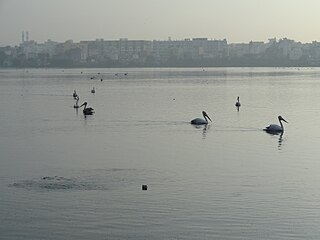
Madiwala lake is one of the biggest lakes in Bangalore, India spread over an area of 114.3 hectare. The water in the lake was fit for drinking till the early 1990s. Since then it has become unfit for drinking due to industrial waste and sewage entering the waterbody. It has gradually become polluted.
Bangalore BRTS was a proposed bus rapid transit system in Bangalore, Karnataka. Beginning with a comprehensive report in 2007, and even earlier, several proposals were made to implement a BRTS in Bangalore.
Located in South Bangalore, Karnataka, India, Kumaraswamy Layout is a sub locality in Banashankari.
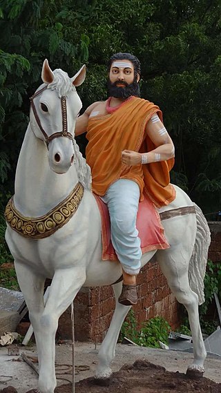
Madivala Machideva, also known as Veera Ganachari Madivala Machideva, was an Indian warrior of the 12th-century.

Bannerghatta Biological Park, also known as the Bannerghatta Zoo, is a zoological garden located in the city of Bengaluru. It was initially a small zoo and picnic corner within Bannerghatta National Park (BNP) which was started in 1974. The bifurcation of the Biological Park and the National Park took place in 2002. The Bannerghatta Biological Park covers a total area of 731.88 hectares and includes a zoo, safari park, butterfly park and rescue centre. The Zoo Authority of Karnataka, the University of Agricultural Sciences, Bangalore, and the Ashoka Trust for Research in Ecology and Environment (ATREE), Bangalore, are collaborating agencies. For the convenience of the general public, the Governing Council of Zoo Authority of Karnataka had decided to rename Bannerghatta Biological Park as 'Bengaluru Bannerghatta Biological Park' (BBBP).

The Central Silk Board junction, commonly known as the Silk Board junction, is a road junction in Bangalore, India. Located adjacent to the Central Silk Board office complex near BTM Layout at the intersection of Hosur Road and Outer Ring Road, the junction is known for its bottleneck traffic congestion as it is one of the busiest intersections in India.
The Pink Line of Namma Metro is under construction and will form part of the metro rail network for the city of Bangalore, Karnataka, India. The 21.25 km (13.20 mi) line connects Kalena Agrahara station on Bannerghatta Road in the south with Nagawara station on Outer Ring Road in the north. The Pink Line is mostly underground but also has a 6.98 km (4.34 mi) elevated section and a 0.48 km (0.30 mi) at-grade (surface) section. There are 18 stations on the line, including 12 underground and 6 elevated ones. Pink Line will have an interchange with the Purple Line at MG Road station. It will also have interchanges with the Yellow line at Jayadeva Hospital station and with the Blue Line at Nagawara. Both these lines are under construction.
The Peripheral Ring Road (PRR) is a proposed 12-lane ring road that runs around Bangalore, Karnataka,. It will have 8-lane access-controlled main carriageway along with 2-lane service roads on both sides. It is outside of Outer Ring Road, Bangalore, which is a 60-kilometre-long road.

