
Namma Metro, also known as Bengaluru Metro, is a rapid transit system serving the city of Bengaluru, the capital city of the state of Karnataka, India. It is the second-longest operational metro network in India with an operational length of 73.75 kilometers, just behind Delhi Metro. Upon its inauguration in 2011, it became the first underground metro system in South India. Namma Metro has a mix of underground, at grade, and elevated stations. Out of the 66 operational metro stations of Namma Metro as of October 2023, there are 57 elevated stations, eight underground stations and one at-grade station. The system runs on standard-gauge tracks.

Campsie is a suburb in the state of New South Wales, Australia. Campsie is 11 kilometres south west of the Sydney central business district, on the southern bank of the Cooks River. Campsie is one of the administrative centres of the City of Canterbury-Bankstown.

Fawdon is an electoral ward of Newcastle upon Tyne, in the county of Tyne and Wear, England. It is also close to the A1 western bypass. The population of the ward is 10,890, reducing to 10,090 at the 2011 Census, 5.7% of the total population of Newcastle upon Tyne. Car ownership in the area is 53.6%, lower than the city average of 54.7%. Until 1974 it was in Northumberland.

Heaton is a district and suburb in the city of Newcastle upon Tyne, in Tyne and Wear, England, two miles east of the city centre. It is bordered by the neighbouring areas of Walkergate to the east, Jesmond to the north west, Byker to the south, and Sandyford to the west. The name Heaton means high town, referring to the area "being situated on hills above the Ouseburn, a tributary of the River Tyne." The area is divided into South Heaton, and High Heaton, representing the north, respectively. For city council elections, the area is split between three wards: Heaton, Manor Park and Ouseburn. Until 1974 it was in Northumberland.
Brahmapur is a neighbourhood of Kolkata in West Bengal, India. It is located in the southern fringes of the city and is flanked by Bansdroni to the north and west, Naktala to the east and Boral to the south.

West Dulwich is a neighbourhood in South London on the southern boundary of Brockwell Park, which straddles the London Borough of Lambeth and the London Borough of Southwark. Croxted Road and South Croxted Road mark the boundary between Southwark to the east and Lambeth to the west. The suburb of West Dulwich dates back to the 17th century when the often flooded land known as Dulwich Common was acquired and drained by Edward Alleyn's estate.

Ovingham is an inner northern suburb of Adelaide, South Australia. It is located in the cities of Charles Sturt and Prospect.

Ridleyton is an inner northern suburb of Adelaide, South Australia. It is located in the City of Charles Sturt.

Albert Park is a suburb of Adelaide, South Australia. It is located in the City of Charles Sturt.
Devon Park is an inner northern suburb of Adelaide, South Australia. It is located in the cities of Port Adelaide Enfield and Charles Sturt beside the Gawler railway line near, but not meeting, the intersection of Torrens Road and Churchill Road.
Madhavaram Milk Colony is a neighbourhood in northern Chennai, a metropolitan city in Chennai district in the Indian state of Tamil Nadu.
Kaggadasapura, also known as Upper Indiranagar is a relatively new area located near DRDO township in CV Raman Nagar, Bangalore, India. Kaggadasapura is an area in Bangalore, and has many apartment complexes. It is located at the coordinates: 12°59'0"N, 77°40'32"E. It is about 4 km from Indiranagar and old (HAL) Airport Road in Bangalore. Defence Avionics Research Establishment (DARE), Center for Artificial Intelligence Research (CAIR) and DRDO Phase II are located at Kaggadasapura.

Line 13 is a north-west to south-east line of the Shanghai Metro network. It runs between Jinyun Road in Jiading and Zhangjiang Road in Pudong. It was once used as a dedicated line for the World Expo to serve the 2010 Shanghai World Expo. The line is colored pink on system maps.

Croydon is an inner western suburb of Adelaide, South Australia. It is located in the City of Charles Sturt.
Surapet, also known as Surapattu and Surapedu, is a neighbourhood in northwestern Chennai, India. Surapet is bordered by Puzhal in the north, Kolathur in the east, Puthagaram in the south, and Puzhal Lake in west.

Barasat Junction is a Kolkata Suburban Railway station in Barasat. It is one of the major suburban railway stations in North 24 Parganas district, West Bengal, India. Generally, people commuting daily use this station for travelling to Kolkata's Central Business District or other towns, with the busiest times at the station being the morning and evening peak periods. This station provides the facility of separate rest rooms for both male & female passengers. Barasat Junction Railway station consists of 6 permanent platforms.

Nagpur Metro is a rapid transit system for the city of Nagpur, Maharashtra, India. Phase I of the metro project cost was estimated to cost ₹8,650 crore but the final project cost incurred was ₹9,279 crore (US$1.1 billion). In February 2014, the Government of Maharashtra gave approval for the Metro project, while the Government of India's Ministry of Urban Development had given "In Principle" approval for the project. On 20 August 2014, Union Cabinet gave approval for the development of the project, and the Prime Minister laid the foundation stone on 21 August. Construction began on 31 May 2015, with trial run beginning on 30 September 2017.
Millfield is a suburb and electoral ward of the City of Sunderland, in Tyne and Wear, England. Most of the buildings in the area were built after the Victorian Era and are mostly built up of large terraced houses built for working-class people of the 20th century. When first built Millfield was located near the heart of Sunderland City Centre, but now has expanded. It now links Pallion with the City Centre.
The Pink Line of Namma Metro is under construction and will form part of the metro rail network for the city of Bangalore, Karnataka, India. The 21.25 km (13.20 mi) line connects Kalena Agrahara station on Bannerghatta Road in the south with Nagawara station on Outer Ring Road in the north. The Pink Line is mostly underground but also has a 6.98 km (4.34 mi) elevated section and a 0.48 km (0.30 mi) at-grade (surface) section. There are 18 stations on the line, including 12 underground and 6 elevated ones. Pink Line will have an interchange with the Purple Line at MG Road station. It will also have interchanges with the Yellow line at Jayadeva Hospital station and with the Blue Line at Nagawara. Both these lines are under construction.
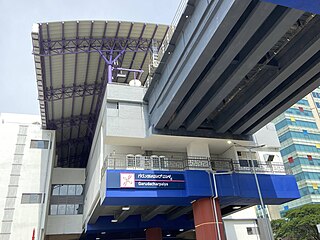
Garudacharpalya is an elevated metro station on the East-West corridor of the Purple Line of Namma Metro in Bengaluru, India. Around this station, holds the Brigade Metropolis followed by some locations like Godrej United, Decathlon Whitefield, Airbus Group India Pvt. Ltd. and many more.
