Related Research Articles

Domlur is a small township located in the eastern part of Bangalore city in India. Domlur was included in the erstwhile Bangalore Civil and Military Station under the British Madras Presidency till it was transferred to the Mysore State in 1949.

Bannerghatta Road is an Indian State Highway in Karnataka. It connects Bangalore with the towns of Bannerghatta, Jigani, and Anekal. It extends for 49 kilometres (30 mi). It starts as a branch from Hosur Road near the Adugodi Christian Cemetery and ends at Anekal.

Basaveshwaranagara, also known as Basaveshwaranagar, Basaveshnagara or Basaveshnagar is a largely residential neighbourhood in the west of Bengaluru, Karnataka, India. It is located to the west of Rajajinagara and is sandwiched between the localities of Mahalakshmi Layout to the north and Vijayanagara to the south, spread across multiple sub-localities, three assembly constituencies and seven Bruhat Bengaluru Mahanagara Palike (BBMP) wards. The area of Basaveshwaranagara is often considered West of Chord Road as it lies to the west of Chord Road, an arterial road in the western part of Bengaluru.

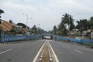
Hebbala, is a neighbourhood in Bengaluru, Karnataka, India, which was once indicative of the north endpoint of the city. Though originally famous for Hebbala Lake, it is now better known for the serpentine maze of flyovers that network the Outer Ring Road and Airport Road on NH 44. The flyover spans a length of 5.23 kilometres (3.2 mi) over all the loops combined. The flyover was built by Gammon India. The lake area in Hebbala is well-known for its picnic spots, a well-maintained park, boating facilities and for the bird watching opportunities.
The Outer Ring Road (ORR), officially renamed as ಡಾ.ಪುನೀತ್ ರಾಜ್ಕುಮಾರ್ ವರ್ತುಲ ರಸ್ತೆ (Dr. Puneeth Rajkumar Vartula Raste), is a ring road that runs around most of the perimeter of the city of Bangalore, Karnataka, India. This 60-kilometre-long (37 mi) road was developed by the Bangalore Development Authority and different sections were opened progressively between 1996 and 2002. IT firms on the Outer Ring Road generate revenue of US$ 22 billion every year, accounting for 32% of Bengaluru’s total IT revenue.
Begur is a suburb of Bangalore in the Indian state of Karnataka. It is located off Bengaluru-Hosur highway. It is said to have been a prominent place during the rule of the Western Ganga Dynasty and later the Chola Kingdom.
Bangalore is the capital and the largest city of the Indian state of Karnataka. It is India's third largest city and fifth largest metropolitan area. Modern Bengaluru was founded in 1537 CE by Kempe Gowda, a vassal of the Vijayanagara Empire. Kempe Gowda built a mud fort in the vicinity of modern Bengaluru. By 1831, the city was incorporated into the British Raj with the establishment of the Bangalore Cantonment. The British returned dominion of the city to the King of Mysore, choosing however, to retain jurisdiction over the cantonment. Therefore, Bengaluru essentially became a twin city, with civic and infrastructural developments of the cantonment conforming to European styles of planning.
Kengeri is a western suburb of Bangalore city, located along Mysore Road.It is bordered by Nagarbhavi and Ullal to the north, Rajarajeshwari Nagar to the east, Kumbalgodu to the west and Uttarahalli to the south.

Old Airport Road is a major road in Bangalore, India. It was renamed from Airport Road after the new Bengaluru International Airport was opened at Devanahalli. Madivala Machideva Road is a 17 km stretch road which begins from the junction of Trinity Church Road and Victoria Road and goes to HAL Bangalore International Airport, Marathahalli, Varthur. Beyond that, the road officially becomes Varthur Road, but since the real estate boom started around 2003, builders have started calling the stretch between the Airport and the Marathahalli Outer Ring Road as Old Airport Road. Even so, due to the high significance of this road it has achieved due to its high accessibility for reaching Whitefield.
Marathahalli is an eastern suburb and outskirts of Bangalore city in Karnataka state of India. The ISRO Headquarters is located near to Marathahalli. The marathahalli main road is mainly used by IT professional which connects to Whitefield and ITPL.

Nagarabhavi is a residential area of Bangalore, Karnataka, India. Located in West Bangalore, Nagarabhavi is located between Mysore Road and Magadi road.
Bangalore BRTS was a proposed bus rapid transit system in Bangalore, Karnataka. Beginning with a comprehensive report in 2007, and even earlier, several proposals were made to implement a BRTS in Bangalore.

The Inner Ring Road is an arterial road in Bangalore, India. It is a six-lane link road connecting Indiranagar and Koramangala. The northern end of the road, beyond Old Airport Road from Domlur junction is called 100 Feet Road.

Magadi Road is an elevated metro station on the East-West corridor of the Purple Line of Namma Metro serving the Magadi Road in Bangalore, India. The station was constructed by Punj Lloyd and was opened to the public on 16 November 2015.

The Central Silk Board junction, commonly known as the Silk Board junction, is a road junction in Bangalore, India. Located adjacent to the Central Silk Board office complex near BTM Layout at the intersection of Hosur Road and Outer Ring Road, the junction is known for its bottleneck traffic congestion as it is one of the busiest intersections in India.

Mysuru Road is an elevated metro station on the East-West corridor of the Purple Line of Namma Metro serving Muthachari Industrial Estate, Nayandahalli and Deepanjali Nagar in Bengaluru. It was opened to the public on 16 November 2015. This metro station is proposed to act as an interchange for the upcoming Orange Line under Phase 3.
Dollars Colony is an upmarket residential locality in Bangalore, India. It is situated towards the north of Bangalore Central Business District. It is located 874 meters above mean sea level.
The Peripheral Ring Road (PRR) is a proposed 12-lane ring road that runs around Bangalore, Karnataka,. It will have 8-lane access-controlled main carriageway along with 2-lane service roads on both sides. It is outside of Outer Ring Road, Bangalore, which is a 60-kilometre-long road.

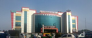
Mysuru Road Bus Station (MRBS), is one of the four major bus stations that serve as mofussil bus station hubs for the city of Bengaluru, India. It is located on Mysuru road. The other three major bus stations in Bengaluru are Kempegowda Bus Station (KBS), Shantinagara Bus Station (SBS) and Basaveshwara Bus Station (BBS). It is the second busiest mofussil bus station in Bengaluru only after Kempegowda Bus Station. It started functioning in 2005.
The Orange Line or ORR-West Line is an upcoming metro line serving Bangalore as part of the Namma Metro network in the city. This metro line will serve the industrial areas, manufacturing units, educational institutions, providing connectivity to the southern part of the city, thereby improving last-mile connectivity to commercial centres, industrial hubs, educational institutions, and healthcare facilities. The line was approved by the Union Cabinet on August 17th, 2024 and is scheduled for completion in 2029.
References
- ↑ "10 traffic 'black spots' in Bangalore: Study". The Indian Express. 1 February 2014. Retrieved 1 July 2017.