Related Research Articles
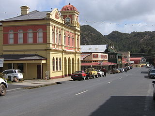
Queenstown is a town in the West Coast region of the island of Tasmania, Australia. It is in a valley on the western slopes of Mount Owen on the West Coast Range.
Richmond is a town in Tasmania about 25 km north-east of Hobart, in the Coal River region, between the Midland Highway and Tasman Highway. At the 2006 census, Richmond had a population of 880.
Beaconsfield is a former gold mining town near the Tamar River, in the north-east of Tasmania, Australia. It lies 40 kilometres north of Launceston on the West Tamar Highway. It is a rural and residential locality in the local government areas (LGA) of West Tamar and Latrobe in the Launceston and North-west and west LGA regions of Tasmania. The 2016 census has a population of 1298 for the state suburb of Beaconsfield.

Somerset is a small township to the west of Burnie, Tasmania, Australia, which shares its name with the County of Somerset, England, UK. Today the city of Burnie encompasses the entire Burnie-Somerset urban area; however, the town is part of the Waratah/Wynyard municipal area.
Gormanston is a town in Tasmania on the slopes of Mount Owen, above the town of Queenstown in Tasmania's West Coast. In the 2016 census, Gormanston had a population of 17.
Renison Bell is an underground tin mine and locality on the West Coast of Tasmania, Australia.
Saltwater River is a rural locality in the local government area (LGA) of Tasman in the South-east LGA region of Tasmania. The locality is about 14 kilometres (8.7 mi) north of the town of Nubeena. The 2016 census has a population of 123 for the state suburb of Saltwater River.
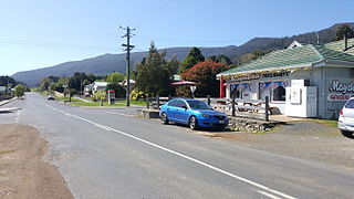
Maydena is a locality in Tasmania, Australia, alongside the River Tyenna.
Tyenna is a rural locality in the local government area (LGA) of Derwent Valley in the South-east LGA region of Tasmania. The locality is about 44 kilometres (27 mi) west of the town of New Norfolk. The 2016 census recorded a population of 43 for the state suburb of Tyenna. It is a settlement on the Tyenna River in Tasmania, located 81 kilometres (50 mi) west of the state capital, Hobart and is currently but a remnant of a once thriving rural community.

St Marys is a small township nestled at the junction of the Tasman Highway and the Esk Highway on the East Coast of Tasmania, Australia approximately 10 kilometres from the coast.
Westerway is a rural locality in the local government areas (LGA) of Central Highlands and Derwent Valley in the Central and South-east LGA regions of Tasmania. The locality is about 29 kilometres (18 mi) north-west of the town of New Norfolk. The 2016 census has a population of 225 for the state suburb of Westerway.

Boobyalla was a shipping port on the north-east coast of Tasmania, Australia during the latter half of the nineteenth century. Coastal vessels ran regularly to the port from other Tasmanian ports, carting tin from the mines around nearby Mount Cameron.

Dundas was a historical mining locality, mineral field and railway location on the western foothills of the West Coast Range in Western Tasmania. It is now part of the locality of Zeehan.

Royal George is a rural locality in the local government areas (LGA) of Northern Midlands (46%), Break O'Day (27%) and Glamorgan-Spring Bay (27%) in the Central, North-east and South-east LGA regions of Tasmania. The locality is about 86 kilometres (53 mi) south-east of the town of Longford. The 2016 census recorded a population of 45 for the state suburb of Royal George.

Coles Bay is an Australian town on the east Coast of Tasmania 192 km north-east of Hobart and 173 km south-east of Launceston, being the main entrance point for visitors to the Freycinet National Park.
Bell Bay is an industrial centre and port located on the eastern shore of the Tamar River, in northern Tasmania, Australia. It lies just south of George Town. In the year ended June 2021, 3.6 million tonnes of exports and imports passed through Bell Bay.

Pioneer is a rural locality in the local government area (LGA) of Dorset in the North-east LGA region of Tasmania. The locality is about 50 kilometres (31 mi) north-east of the town of Scottsdale. The 2016 census recorded a population of 89 for the state suburb of Pioneer.
Mount Zeehan is a mountain in Western Tasmania, west of the West Coast Range. It has an elevation of 701 metres (2,300 ft) above sea level. The closest town is Zeehan, about 4.93 kilometres (3 mi) away.
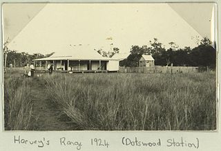
Dotswood is a rural locality in the Charters Towers Region, Queensland, Australia. In the 2021 census, Dotswood had a population of 83 people.
Florentine Junction, also known as Pillinger’s Creek, Risby’s Junction, Florentine Rail Yard and Florentine Depot, is the terminus of the Derwent Valley Railway, a 3’ 6” narrow gauge railway that operates from New Norfolk in Tasmania, Australia. The station opened in 1936 but closed in the mid twentieth century when the railway beyond Kallista was closed.
References
- ↑ "OSMIRIDIUM". The News . Vol. II, no. 365. Tasmania, Australia. 1 August 1925. p. 1 (SECOND EDITION). Retrieved 24 June 2023– via National Library of Australia.
- ↑ Brownlie, Alex; McGlashan, N. D. (Neil D.); University of Tasmania. Department of Geography, (issuing body) (1978), Adamsfield : the town that lived and died, Department of Geography, University of Tasmania for the Division of Recreation, Education Department, retrieved 24 June 2023
- ↑ "Adamsfield, Tasmania, Australia".
- ↑ Nye, P. B. (Percival Bartlett); Tasmania Department of Mines; Geological Survey of Tasmania (1929), The osmiridium deposits of the Adamsfield District, Dept. of Mines, retrieved 24 June 2023
- ↑ Premier Postal History. "Post Office List". Premier Postal Auctions. Retrieved 16 June 2012.
- ↑ Gowlland, Kathleen; Gowlland, Ralph; Gowlland, Timothy (1973), Adamsfield : the town that lived and died, Richmond & Sons, retrieved 24 June 2023
42°44′S146°19′E / 42.733°S 146.317°E
| | This Tasmania geography article is a stub. You can help Wikipedia by expanding it. |