Cuenca is a city and municipality of Spain located in the autonomous community of Castilla–La Mancha. It is the capital of the province of Cuenca.

The Júcar or Xúquer is a river in Spain, on the Iberian Peninsula. The river runs for approximately 509 km from its source at Ojuelos de Valdeminguete, on the eastern flank of the Montes Universales in the Sistema Ibérico. Its most important tributary is the Cabriel.

Carcaixent is a town and municipality in the province of Valencia, eastern Spain, with c. 20,000 inhabitants. Its origins go back to prehistoric Iberian and Roman times, with some remainders in its area. It is located in the Ribera Alta comarca, 40 km south of the provincial capital Valencia. It is the birthplace of the orange growth and its flourishing commerce in the 19th and 20th centuries. Currently, its inhabitants live basically on agriculture and the service sector.
Fitero is a town and municipality located in the province and autonomous community of Navarre, northern Spain.

Ontinyent is a municipality in the comarca of Vall d'Albaida in the Valencian Community, Spain. It is situated on the banks of the Clariano River, a tributary of the Xúquer, and on the Xàtiva–Alcoi railway. Ontinyent is near the Sierra de Mariola Natural Park.

Cullera is a city and municipality of Spain located in the Valencian Community. It is part of the province of Valencia and the Ribera Baixa comarca. The city is situated near the discharge of the river Júcar in the Mediterranean Sea.
Ribera Alta is a comarca in the province of Valencia, Valencian Community, Spain.

La Pobla Llarga is a municipality in the comarca of Ribera Alta in the Valencian Community, Spain. Well known of the orange growth and its flourishing commerce in the 19th and 20th centuries. Currently, its inhabitants live basically on agriculture and the service sector.

Ribera del Júcar is a Spanish Denominación de Origen Protegida (DOP) for wines located in the province of Cuenca along the banks of the River Júcar and covers 7 municipalities.

Villanueva de la Jara, popularly called La Jara, is a town and municipality in the Manchuela Conquense comarca, this in turn is part of the La Manchuela comarca, province of Cuenca, in Castile-La Mancha, Spain. It is known for the cultivation of portobellos and other edible fungi which is the main economic activity of the locality.
Ibn Amira (1186- 1258/60), full name: Abū al-Muṭarrif Aḥmad bin Abdallāh bin al-Ḥusayn bin Aḥmad Ibn Amīra al-Makhzūmī was a historian, poet, and scholar of law from al-Andalus during the reign of the Almohad Caliphate. Ibn Amira was Qadi of Mallorca and worked for the Almohad sultan in Valencia and Seville. He moved to Morocco in 1239/40 and continued to work for the sultan there.

The Monastery of Sant Jeroni de Cotalba is a monastic building of Valencian Gothic, Mudéjar, Renaissance, Baroque and Neoclassical styles constructed between the 14th and 18th centuries, located in the municipal area of Alfauir, (Valencia), Spain, about 8 km. from the well-known city of Gandia.
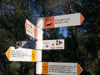
The Route of the Monasteries of Valencia (GR-236) is a religious and cultural route that connects five monasteries located in central region of the Province of Valencia,, in Spain. The Route was inaugurated in the year 2008.
Bernard of Alzira was an Andalusian prince and diplomat, later turned from Islam to become a religious brother of the Cistercian Order. He is a martyr of the Catholic Church, venerated particularly in the Valencian Community and Catalonia. The most important celebrations in his honor are held in the city of Alzira, of which he is patron, and the Poblet Monastery in Tarragona.
The Monastery of Santa María de Aguas Vivas, located in the municipality of Carcaixent (Valencia), Spain, is a religious building dating back to the 13th century.

The Monastery of Santa Maria de la Murta is a former monastery of the order of the Hieronymites located in the Valley of La Murta in Alzira (Valencia), Spain.

Alarcón is a municipality in the province of Cuenca, in the autonomous community of Castilla-La Mancha, Spain.

The Alarcón Dam is a gravity dam on the upper course of the Júcar River. It is located 6 kilometres (3.7 mi) from Alarcón, in the province of Cuenca, in the autonomous community of Castilla-La Mancha, Spain.
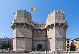
The Serrans Gate or Serranos Gate, also known as Serrans Towers or Serranos Towers is one of the twelve gates that formed part of the ancient city wall, the Christian Wall, of the city of Valencia, Spain. It was built in Valencian Gothic style at the end of the 14th century. Its name is probably due to its location in the northeast of the old city centre, making it the entry point for the royal road connecting Valencia with the comarca or district of Els Serrans as well as the entry point for the royal road to Barcelona, or because the majority of settlers near there in the time of James I of Aragon were from the area around Teruel, whose inhabitants were often called serrans by the Valencians. Alternatively, the gate may also have been named after an important family, the Serrans, who lived in a street with the same name.

Muntanya Assolada is a Bronze Age settlement located on the right bank of the Xúquer river, in Spain, built on the top of a spur of the Corbera mountain range, dominating the river plain from a height of 227 metres (745 ft) above sea level. It is located in the municipality of Alzira, Valencia, Spain.