San Cristóbal de las Casas, also known by its native Tzotzil name, Jovel, is a town and municipality located in the Central Highlands region of the Mexican state of Chiapas. It was the capital of the state until 1892, and is still considered the cultural capital of Chiapas.

Santa Cruz del Quiché is a city, with a population of 78,279, in Guatemala. It serves as the capital of the El Quiché department and the municipal seat of Santa Cruz del Quiché municipality. The city is located at 15.03°N 91.15°W, at an elevation of 2,021 m above sea level. It has an airport, Quiché Airport, located just south of the city.
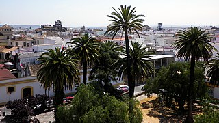
El Puerto de Santa María, locally known as El Puerto and historically in English as Port Saint Mary, is a municipality of Spain located on the banks of the Guadalete River in the province of Cádiz, Andalusia. As of 2016, the city has a population of c. 88,184, of which some 50,000 live in the urban center, and the remainder in the surrounding areas.

The Historic Centre of Lima is the historic city centre of the city of Lima, the capital of Peru. Located in the city's districts of Lima and Rímac, both in the Rímac Valley, it consists of two areas: the first is the Monumental Zone established by the Peruvian government in 1972, and the second one—contained within the first one—is the World Heritage Site established by UNESCO in 1988, whose buildings are marked with the organisation's black-and-white shield.

Chiclana de la Frontera is a town and municipality in southwestern Spain, in the province of Cádiz, Andalucía, near the Gulf of Cádiz. It belongs to the association of municipalities of the Bay of Cádiz, the provincial capital of Cádiz, Jerez de la Frontera, San Fernando, El Puerto de Santa María, Puerto Real and Rota which form the third largest metropolitan area in Andalusia, behind Seville and Málaga, and the twelfth largest in Spain. It is located 20 kilometres south-east from Cádiz, and borders the municipalities of San Fernando and Puerto Real to the north and Conil de la Frontera to the south. In 1877, the municipality's population was 11,677; in 2012, it was 81,473. It has a surface area is 203 square kilometres (78 sq mi) and a population density of 401 inhabitants / km2. The average elevation is 11 metres (36 ft) above sea level. The economy depends largely upon modern industry, especially salt processing and tourism, and the municipality is known for its beaches such as the 6 kilometres (3.7 mi) long Playa de la Barrosa, hotels and golf courses in the resort of Novo Sancti Petri. The municipality contains the largest number of hotel beds in the Province of Cádiz and the Costa de la Luz. The town's newspaper, Chiclana Información, is distributed on Saturday mornings.

San Ángel is a colonia (neighborhood) located in the southwest of Mexico City in Álvaro Obregón borough. Historically it was a rural community called Tenanitla in the pre-Hispanic period. Its current name is derived from the El Carmen monastery school called San Ángel Mártir. It remained a rural community centered on the monastery until the 19th and 20th centuries when the monastery closed and the area joined the urban sprawl of Mexico City. The area still contains many historic buildings, and El Carmen is one of the most visited museums in the city. Its annual flower fair, Feria de las Flores , has been held since 1856.

Arcos de la Frontera is a town and municipality in the Sierra de Cádiz comarca, province of Cádiz, in Andalusia, Spain. It is located on the northern, western and southern banks of the Guadalete river, which flows around three sides of the city under towering vertical cliffs, to Jerez and on to the Bay of Cádiz. The town commands a fine vista atop a sandstone ridge, from which the peak of San Cristóbal and the Guadalete Valley can be seen. The town gained its name by being the frontier of Spain's 13th-century battle with the Moors.

Alhaurín el Grande is a town located in the province of Málaga in the autonomous community of Andalusia in southern Spain.

The Albaicín, also spelled Albayzín, is a neighbourhood of Granada, Spain. It is centered around a hill on the north side of the Darro River which passes through the city. The neighbourhood is notable for its historic monuments and for largely retaining its medieval street plan dating back to the Nasrid period, although it nonetheless went through many physical and demographic changes after the end of the Reconquista in 1492. It was declared a World Heritage Site in 1994, as an extension of the historic site of the nearby Alhambra.

Ciudad Colonial is the historic central neighborhood of the Dominican Republic's capital Santo Domingo. It is the oldest continuously inhabited European-established settlement in the Americas. The area has been declared a World Heritage Site by UNESCO. It is also known as Zona Colonial or more colloquially as "La Zona".

Venta del Moro is a municipality in the comarca of Requena-Utiel in the Valencian Community, Spain.

Tenango del Aire is a municipality located in the southeast portion of the State of Mexico and is about 42 km southeast of Mexico City. The municipal seat is the town of Tenango del Aire. The municipality is bordered by Temamatla, Tlalmanalco, Juchitepec, and Ayapango. Despite the fact that this municipality is distinctly rural, it falls within the Mexico City Metropolitan Area. The name “Tenango del Aire” came about in two parts. Originally and until 1890, the town was known as Tenango de Topopula. “Tenango” means “walled in” or “fenced by stones.” The second part is due to visits by President Porfirio Diaz, who commented on the winds that are prevalent here. “del Aire” means “of the air.”

Manchuela or La Manchuela is a comarca located in Castile-La Mancha and Valencian Community, Spain.
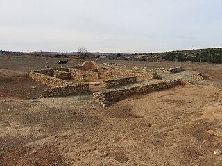
Kelin was an ancient Iberian city located on the hill of Los Villares. The site was inhabited from the Proto-Iberian period to the Late Iberian period. The site was walled and covered around 10 hectares. The archaeological site has been known from the mid-18th century, although it was first excavated archaeologically in 1956, with later campaigns as recent as 2011.
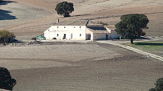
A cortijo is a type of traditional rural dwelling in the southern half of Spain, including all of Andalusia and parts of Extremadura and Castile-La Mancha.

Valencian Art Nouveau is the historiographic denomination given to an art and literature movement associated with the Art Nouveau in the Valencian Community, in Spain.

The Casa de las Campanas is one of the three oldest buildings in the city of Pontevedra in Spain, and perhaps the oldest civil building. It is located in Don Filiberto street, at number 11, in the old town.