Moncada, Valencia

Last updated
Moncada
Escut de Montcada 2.svg
Valencia-loc.svg
Red pog.svg
Moncada
Location in Spain
Spain Valencian Community location map.svg
Red pog.svg
Moncada
Moncada (Valencian Community)
Spain location map with provinces.svg
Red pog.svg
Moncada
Moncada (Spain)
Coordinates: 39°32′35″N0°23′34″W / 39.54306°N 0.39278°W / 39.54306; -0.39278
CountryFlag of Spain.svg  Spain
Autonomous community Flag of the Valencian Community (2x3).svg  Valencian Community
Province Valencia
Comarca Horta Nord
Judicial district Moncada
Government
   Alcalde Amparo Orts Albiach (PSOE)
Area
  Total15.6 km2 (6.0 sq mi)
Elevation
37 m (121 ft)
Population
 (2021) [1]
  Total21,875
  Density1,400/km2 (3,600/sq mi)
Demonym(s) Moncadense/a, Moncanero/a
Time zone UTC+1 (CET)
  Summer (DST) UTC+2 (CEST)
Postal code
46113
Official language(s) Spanish and Valencian
Website Official website

Moncada is a municipality in the comarca of Horta Nord in the Valencian Community, Spain.

Contents

Place names

On the official writings in Latin Monscatanus was used, from mons ('mountain') and Celtic catanus ('juniper'?), making Montcada the correct original spelling and Moncada a vulgarization of the name. However, officially the town's name is written Moncada, [2] but also in Valencian accept dual Montcada/Moncada denomination, as the origin of the name is linked from the 13th century to the lineage of the House of Montcada, although the removal of the letter t dates from the 15th century, where previously, the Moncada form was used in the earliest known documents relating to the Royal Séquia of the municipality, this denomination coming from the vulgar pronunciation, simplified by omitting the letter t. [3] Moreover, government agencies on language as the Valencian Academy of Language always use Montcada in Valencian to refer to the name of the municipality of Valencia. [4]

Geography

The relief of the municipality is formed by a quaternary plain on the gently rising in the northern and western parts of Tertiary hills, an extension of the Sierra Calderona, and reaching its highest point in Tos Pelat (92 m) hill situated on the border between the terms of Bétera, Valencia and Moncada. The hills extend to the town center that has already begun to occupy the hill of Santa Barbara.

The Carraixet Ravine penetrates by northwest and cuts across the term to go out by southeast, along The Alfara Patriarch.

Neighborhoods and districts

The urban environment is the core of Moncada, together with the following population centers: [5]

  • Barrio de Los Dolores
  • Barrio del Pilar

Bordering towns

The municipality of Moncada borders the following locations: Albalat dels Sorells, Alfara del Patriarca, Bétera, Foios, Museros, Náquera and Valencia, all of the Province of Valencia. [2]

History

Commune House of the Royal Acequia de Moncada. Montcada. Casa de la Reial Sequia 1.jpg
Commune House of the Royal Acequia de Moncada.
Old City Hall, which houses the library and the archaeological museum. Montcada. Antic ajuntament.jpg
Old City Hall, which houses the library and the archaeological museum.

The territory of the municipality of Moncada was the subject of an intense human occupation from the early days of Romanization. There are few data we have from earlier times. In the area known as the Xop and in some fields for extraction of clay for pottery, appeared a few fragments of ceramic belonging to handmade vessels and two arrowheads. Also before the Roman times is the Iberian settlement of Tos Pelat, which remaining parts of its walled town and were seen sections of the walls of the rooms, and were for a long time been collected fragments of Iberian vessels with geometric decoration painted and even whole pieces. We know the existence of two large rustic Roman villas, one in the departure of Pou or Pousaig and the other in the departure of Bordellet. By the characteristics of the collected materials, both towns should to blossom during the 2nd and early 3rd centuries AD.

The origin of the population is attributed to the Iberian or Roman period, due to the archaeological materials found in its term. King James I in 1239 granted to the inhabitants of the conquered lands of Valencia, of all water and major medium and minor irrigation ditch, but literal, and expressly reserved the channel that was called Real, that it was going to Puzol, better known as "Royal Ditch of Moncada" that irrigate the most of the left bank of the River Turia, from Paterna to Puçol. It extended the boundaries of irrigation on the twenty towns and thirteen districts that conform the irrigable area of the Royal Ditch of Moncada, specifically the populations of Quart de Poblet, Paterna, Burjassot, Godella, Rocafort, Moncada, Alfara of the Patriarch, Vinalesa, Bonrepos and Mirambell, Almàssera, Foios, Meliana, Albalat dels Sorells, Museros, Albuixech, Massalfassar, Massamagrell, La Pobla de Farnals, Rafelbuñol, El Puig and Puzol, and the hamlets of Benimàmet, Beniferri, Masarrojos, Benifaraig, Carpesa, Borbotó, Casas de Bárcena, Mahuella, Tauladella, Rafalell and Vistabella.

The first written documentation come from, however, of the time of the Catalan conquest. Some years later, Moncada returned to crown and was changed to the Order of the Temple by the Farmhouse of Ruzafa in 1246 (to have greater strategic value by keeping the southern flank of the capital of the Kingdom). In 1248 the commander of the Templars granted Municipal corporation Population Charter and about in the same time was created the bailiff of Moncada, one of the richest of the Order of the Temple, and after the Order of Montesa, which was passed after being suppressed in the early 14th century.

During the War of Succession in 1706, Moncada was occupied by the Bourbon army. This occupation lasted short time as Basset, Austracist general, forced it to raise its reals.

After the Spanish Civil War, the city suffered a widespread destruction during the conflict and Salvador Rodrigo Rosalen is left in front of City Hall.

Moncada Islamic Necropolis

In 1996 to realize the excavations for the foundations of a house in Barreres street were found seven human burials pointing to an Islamic origin; Islamic culture were dated between the 11th and 13th centuries. Located archaeologically the location of the Islamic necropolis, the subsequent discovery in 2006 of some silos and the remains of two houses in The Ravalet, dating from the Almohad period (12th century), allowed the archaeological finding Islamic origin or previous of the city. [6]

Between November 2006 and January 2007 in San Roque Street, following the demolition of a house, they found 25 to 30 bodies of young people in good condition and a few babies in almost good condition, dating from around the 12th century. Some showing large head injuries, which were shattered by impacts. It is presumed that the bodies found professed the Muslim religion by the way in which lay buried.

In early 2006, were found traces of the Moorish occupation, in what some experts have dubbed "the hamlet of Moncada" next to the Palace of the Counts of Rótova, current city council of the Municipality of Moncada. This finding corresponds to a first level. In the second level were found houses dating from the 16th century.

Demography

Moncada has a population of 21,847 inhabitants in 2010.

Economy

Moncada's economy, as well as the other towns in the Valencia region of l'Horta, is mostly agricultural, due to the favourable location and the fertility of the soil in the area. Despite the dominance of the primary sector, Moncada has experienced over the last years a significant growth in the tertiary sector, caused primarily by strong demand in the hospitality sector arising from the close presence of the Cardenal Herrera CEU University, whose influx of students has served as a stimulus for the modest local hotel industry.

Transportation

The easiest way to reach Moncada is from the city of Valencia through the CV-308.

Moncada has three stations of Metro Valencia (Moncada-Alfara, Seminar-CEU and Masias).

It also has a bus to Valencia and intercity bus service connecting the town of Moncada with its various neighborhoods.

Notable buildings

Gate Church of San Jaime. Montcada. Esglesia. Portada.jpg
Gate Church of San Jaime.

Festivals

- Falla La Tauleta (1973)
- Falla El Mercat (1982)
- Falla Del Poble (1982)
- Falla Badia (1984)
- Falla Tos Pelat (1987)
- Falla Amics de Masies (1994)
- Falla El Palmar (1996)
- Falla Les Eres (1997)
- Falla El Campet (1997)
- Falla Archprieste Vila - Sant Enric (2000)

Notable people

Related Research Articles

<span class="mw-page-title-main">Valencia Fallas</span> Traditional celebration in Valencia, Spain

The Fallas is a traditional celebration held annually in commemoration of Saint Joseph in the city of Valencia, Spain. The five main days celebrated are from 15 to 19 March, while the Mascletà, a pyrotechnic spectacle of firecracker detonation and fireworks display, takes place every day from 1 to 19 March. The term Fallas refers to both the celebration and the Falla monuments burnt during the celebration. A number of towns in the Valencian Community have similar celebrations inspired by the original Fallas de Valencia celebration. For example, the bonfires of Alicante or the Fiestas de la Magdalena in Castellón de la Plana. The Fallas festival was added to UNESCO's intangible cultural heritage of humanity list on 30 November 2016.

<span class="mw-page-title-main">Valencia</span> Municipality in Spain

Valencia is the capital of the autonomous community of Valencia and the third-most populated municipality in Spain, with 792,492 inhabitants (2022). It is the capital of the province of the same name. The wider urban area comprising the neighbouring municipalities has a population of around 1.6 million, constituting one of the major urban areas on the European side of the Mediterranean Sea. It is located on the banks of the Turia, on the east coast of the Iberian Peninsula at the Gulf of Valencia, north of the Albufera lagoon.

<span class="mw-page-title-main">Alboraya</span> Municipality in Valencian Community, Spain

Alboraya or Alboraia is a town and municipality of the province of Valencia, Spain. It is situated very close to the city of Valencia.

<span class="mw-page-title-main">Horta Nord</span> Comarca in Valencian Community, Spain

Horta Nord is a comarca in the province of Valencia, Valencian Community, Spain.

<span class="mw-page-title-main">El Puig</span> Municipality in Valencian Community, Spain

El Puig, officially El Puig de Santa Maria since 2012, is a village situated 15 km north of the city of Valencia in the comarca of Horta Nord, Spain. Its name means "hill" in Valencian). The municipality comprises three main areas, the first being the village itself, which is dominated by a monastery, and two large wooded hills next to it, the largest of which has the ruins of a castle fortress at the top. Originally, however, there was another hill named La Pedrera which disappeared gradually during the 20th century to make way for the V-21 motorway, with the rock being used to construct one of the jetties at Valencia's port. The second section is the coastal area of 4 km of beach with eight housing developments that are generally only inhabited in the summer; and finally, there is an industrial park located between them.

<span class="mw-page-title-main">Alaquàs</span> Municipality in Valencian Community, Spain

Alaquàs is a municipality in the Horta Oest comarca in the Valencian Community.

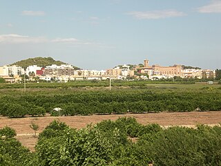
Alfara del Patriarca is a municipality in the comarca of Horta Nord in the Valencian Community, Spain.

Bétera is a municipality in the comarca of Camp de Túria in the Valencian Community, Spain. With 23.647 inhabitants, it is the second most populous town in the Camp de Túria shire, in the second zone of the Valencia metropolitan area.

Chella is a municipality in the comarca of Canal de Navarrés in the Valencian Community, Spain.

<span class="mw-page-title-main">Foios</span> Municipality in Valencian Community, Spain

Foios is a municipality in the comarca of Horta Nord in the Valencian Community, Spain. It has a population of 7,342.

<span class="mw-page-title-main">Paterna</span> Municipality in Valencian Community, Spain

Paterna is a city and a municipality in the province of Valencia in the Valencian Community, Spain. It is located northeast of the comarca of L'Horta de Valencia, 5 kilometres northwest of the inland suburbs of Valencia, and on the left bank of the river Turia. Its population in 2014 was 67,156 inhabitants, being the eleventh city by population in the Valencian Community.

<span class="mw-page-title-main">Puçol</span> Municipality in Valencian Community, Spain

Puçol is a Spanish municipality located in the province of Valencia, part of the Valencian Community autonomous region. It belongs to the Horta Nord. The municipality borders El Puig south and Sagunt to the north. It has 19,975 inhabitants (01/01/2021), of whom 9,839 are men and 10,136 are women.

<span class="mw-page-title-main">Quart de Poblet</span> Municipality in Valencian Community, Spain

Quart de Poblet is a municipality in the comarca of Horta Oest in the Valencian Community, Spain. It has 25,499 inhabitants.

Manuel Palau Boix was a Spanish composer and teacher in Valencia Conservatory. He wrote a large number of symphonic, band, choral and chamber works. He was one of the most popular and important composers of his time. He received the Spanish National Music Award twice, first in 1927 and again in 1945. His music is known within the Spanish classical music for being a representative of what it has been called “Mediterranean” style, like other Spanish musicians such as Vicente Asencio or Oscar Esplá.

<span class="mw-page-title-main">Horta of Valencia</span> Historical comarca and urban area in Valencian Community, Spain

The Horta of Valencia is a historical comarca and urban area of the Valencian Community. The Horta of Valencia consists of Valencia and three comarcas: Horta Nord, Horta Sud, Horta Oest.

<span class="mw-page-title-main">Carraixet</span>

The Carraixet ravine is a course of water from the north of the Valencian province, in the Valencian Community (Spain). It begins in Gátova and collects waters from the sloped southern side of the Calderona mountain range. It flows into the Mediterranean Sea through the town of Alboraya. At its mouth, it is also called the Olocau ravine or the Peralvillo ravine. In the Book of the Facts James I named it riu Sec, while discussing the Battle of the Puig.

<span class="mw-page-title-main">Vía Verde de Ojos Negros</span>

The Ojos Negros Greenway, is a 160-kilometre greenway in Spain running between the village of Santa Eulalia del Campo in the province of Teruel in Aragón and the village of Algimia d'Alfara, in the province of Valencia in the Valencian Community.

<span class="mw-page-title-main">Pobles del Nord</span> Valencian municipality, Spain

Pobles del Nord is the 17th district of the city of Valencia (Spain). It is composed of seven towns, which were annexed to Valencia between 1888 and 1900, which are today considered neighborhoods: Benifaraig, Pueblo Nuevo, Carpesa, Casas de Bárcena, Mahuella, Tauladella, Rafalell i Vistabella, Masarrochos and Borbotó.

<span class="mw-page-title-main">Valencian Canton</span>

The Valencian Canton, also known as the Canton of Valencia, was one of the first independent cantons proclaimed during the Cantonal rebellion that took place during the First Spanish Republic (1873-1874). It was officially proclaimed on July 18, 1873, and 178 municipalities of the Valencia province adhered to it. It fell on August 8, when the troops of Martínez Campos, sent by the federal republican government of Nicolás Salmerón, entered the city of Valencia, causing the surrender of the Canton.

<span class="mw-page-title-main">Benifaraig, Valencia</span> Pedania located within the city of Valencia, Spain.

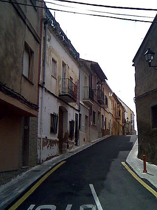
Benifaraig is a pedania of the city of Valencia (Spain), belonging to the district of Poblados del Norte. It is bordered on the west by Godella, on the east by Alfara del Patriarca, on the north by Moncada and on the south by Borbotó and Carpesa. Its census population in 2022 was 993 inhabitants. It was an independent municipality until 1900, when it became a pedania of the city of Valencia.

References

  1. Municipal Register of Spain 2018. National Statistics Institute.
  2. 1 2 Moncada Archived 2011-07-20 at the Wayback Machine in CIVIS: Municipal Information System of the Generalitat Valenciana Archived 2009-04-23 at the Wayback Machine
  3. Casanova, Emili, Congrés Internacional de Toponímia i Onomàstica Catalanes, València, April 21, 2001, Universitat de València, 2002, ISBN   978-84-370-5443-8, Electronic text (online) available at www (p-319)
  4. AVL: Spelling and noble in Valencia
  5. Moncada Nuclei Population [ permanent dead link ] and INE National Statistics Institute: List of population units Moncada
  6. Ajuntament de Moncada: urban archaeological interventions Archived 2010-10-05 at the Wayback Machine