The Penobscot River is a 109-mile-long (175 km) river in the U.S. state of Maine. Including the river's West Branch and South Branch increases the Penobscot's length to 264 miles (425 km), making it the second-longest river system in Maine and the longest entirely in the state. Its drainage basin contains 8,610 square miles (22,300 km2).

The Allagash River is a tributary of the Saint John River, approximately 65 miles (105 km) long, in northern Maine in the United States. It drains in a remote and scenic area of wilderness in the Maine North Woods north of Mount Katahdin. The name "Allagash" comes from the Abenaki language, a dialect of the Algonquin languages, spoken by the Penobscot Tribe The word, /walakéskʸihtəkʸ/, means "bark stream".

South Twin Lake having about 3,200 acres (13 km2) is wholly within Penobscot County, Maine. It is about 6 miles (10 km) west of Millinocket, Maine and is part of the Pemadumcook Chain of Lakes. The lake is centered at 45°37.25′N68°51′W and has spillway elevation 492 feet (150 m) above sea level. It is part of the watershed of the West Branch of the Penobscot River.

The Pemadumcook Chain of Lakes are a set of large lakes in north-central Maine in the United States.

Goose Rocks Light is a sparkplug lighthouse located near North Haven, Maine in Penobscot Bay. It stands at the eastern entrance to the Fox Islands Thoroughfare, a busy mile-wide passage separating North Haven from Vinalhaven. Built in 1890, it was added to the National Register of Historic Places as Goose Rocks Light Station on January 21, 1988. The structure is now privately owned by a preservation group, and remains an active aid to navigation.

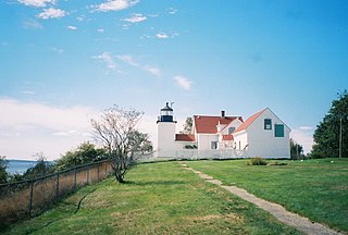
The Fort Point Light, or Fort Point Light Station, is located in Fort Point State Park, in Stockton Springs, Maine. A lighthouse at this point has served as an active aid to navigation since 1835; the present lighthouse dates to 1857, and is listed on the National Register of Historic Places.

The West Branch Penobscot River is a 117-mile-long (188 km) tributary of the Penobscot River through the North Maine Woods in Maine. The river is also known as Abocadneticook, Kahgognamock, and Kettegwewick.

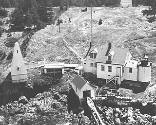
Browns Head Light is a lighthouse in Vinalhaven, Maine. Established in 1832, it is an active aid to navigation, marking the southern side of the western entrance to the Fox Island Thoroughfare, a busy strait separating Vinalhaven Island from North Haven. The present lighthouse was built in 1857; and was listed on the National Register of Historic Places as "Browns Head Light Station" on January 27, 1983.

Heron Neck Light is a lighthouse on Green's Island in Vinalhaven, Maine at the south end of Penobscot Bay. It was established in 1854 as an aid to navigation for Vinalhaven's main port, and for the Hurricane Channel extending northwest from Heron's Neck. The light was automated in 1984. It was listed on the National Register of Historic Places as Heron Neck Light Station on January 21, 1988.

Pumpkin Island Light is a lighthouse on Pumpkin Island, at the northwestern entrance to Eggemoggin Reach, a channel running northwest to southeast between Penobscot Bay and Blue Hill Bay on the central-eastern coast of Maine. The light station was established in 1854 and discontinued in 1933. It was listed on the National Register of Historic Places as Pumpkin Island Light Station on February 1, 1988. The island and former light station are privately owned.

Saddleback Ledge Light is a lighthouse on Saddleback Ledge, an islet lying between Isle au Haut and Vinalhaven, Maine, in the middle of the southeastern entrance to Penobscot Bay. The station was established and the current structure, designed by Alexander Parris, was built in 1839. One of Maine's oldest lighthouses, it was listed on the National Register of Historic Places as Saddleback Ledge Light Station on March 14, 1988.

Forest Lodge is a historic homestead in rural northern Oxford County, Maine. Located in a hard-to-reach corner of Upton on the northern bank of the Rapid River, it consists of a complex of seven buildings, four of which are residential. The complex was owned and occupied by the family of writer Louise Dickinson Rich (1903–91) on a year-round basis between 1933 and 1944, and as Rich's summer residence until 1955. The property, as well as the surrounding country and its small number of year-round residents and seasonal visitors, were a recurring theme in her writings, which spanned forty years. The property was listed on the National Register of Historic Places in 2008.

Chesuncook is a small unincorporated settlement on the northwestern shore of Chesuncook Lake in rural central Piscataquis County, Maine. A small village, originally supporting logging operations in the area, has existed here since at least the time of Henry David Thoreau, who wrote about it in The Maine Woods. The village is now a primarily seasonal settlement that caters principally to outdoors enthusiasts. Seven historic properties on or near the "Main Street" fronting the lake were listed on the National Register of Historic Places in 1973.

The Ellsworth Power House and Dam, the latter also known as the Union River Dam, is a hydroelectric power generation facility on the Union River in Ellsworth, Maine. The dam, located just north of downtown Ellsworth, impounds the river to create Leonard Lake, named for project's engineer, James Leonard. The powerhouse is a Renaissance Revival building located at the western end of the dam. The power plant, built in 1907, was one of the first peaking power plants built in the state, and the hollow concrete dam is one of the highest Ambursen-type buttress dams ever built. The facility was listed on the National Register of Historic Places in 1985.

The Eagle Lake Tramway is a historic timber-transport mechanism in the remote North Maine Woods in northeastern USA. The tramway, built in 1902 and operated until 1907, transported timber across a neck of land between Eagle Lake and Chamberlain Lake, with one end eventually becoming the eastern terminus of the Eagle Lake and West Branch Railroad in 1927. The remnants of the tramway and rail station were listed on the National Register of Historic Places as the Tramway Historic District in 1979. The tramway is part of the Allagash Wilderness Waterway, a Maine state park.

Pittston Farm is a historic farm and community complex in a remote part of northern Somerset County, Maine. Located down logging roads about 20 miles (32 km) north of the village of Rockwood, the farm was developed c. 1910 by the Great Northern Paper Company to provide food and other resources to workers on logging drives in Maine's northern forests. It is believed to be the best preserved of the few such facilities established, and was listed on the National Register of Historic Places in 2000. Its surviving buildings are currently operated as a tourist establishment.

The Old Tavern is a historic travelers' accommodation at Maine State Route 188 and Long Ridge Road in Burlington, Maine. Built in 1844, it predominantly catered to the lumbermen working on logging drives in the region. The building was acquired by the local historical society in 1984, and is now a local history museum. It was listed on the National Register of Historic Places in 1986.

The Brookfield Renewables Milford Dam, also known as the Milford Dam of Versant Power, is a hydroelectric power generation facility on the Penobscot River in Milford, Maine. Its main building, a handsome Romanesque structure, stands at the eastern end of the Milford Dam. Built in 1906, it was at that time the largest hydroelectric facility in the state, and its construction marked a shift from water to electrical power of area industries. It was listed on the National Register of Historic Places in 1988.

The Land's End Historic District encompasses a well-preserved enclave of summer residences built in the early 20th century in the Port Clyde area of St. George, Maine. Developed between 1907 and 1919 by Russell W. Porter, it includes an architecturally eclectic mix of modestly scaled cottages. The district was listed on the National Register of Historic Places in 2011.

The Whitehead Lifesaving Station was a maritime rescue facility on Whitehead Island, an island off the coast of St. George, Maine at the mouth of Penobscot Bay. Established in 1874 by the United States Life-Saving Service, its original building is one of the best-preserved of the five stations built by the service on the coast of Maine and New Hampshire at that time. The station was in active use until the 1940s, and is now privately owned. It was listed on the National Register of Historic Places in 1988.


