
Dupont Circle is a historic roundabout park and neighborhood of Washington, D.C., located in Northwest D.C. The Dupont Circle neighborhood is bounded approximately by 16th Street NW to the east, 22nd Street NW to the west, M Street NW to the south, and Florida Avenue NW to the north. Much of the neighborhood is listed on the National Register of Historic Places. However, the local government Advisory Neighborhood Commission and the Dupont Circle Historic District have slightly different boundaries.

Massachusetts Avenue is a major diagonal transverse road in Washington, D.C., and the Massachusetts Avenue Historic District is a historic district that includes part of it.

Sheridan Circle is a traffic circle and park in the Sheridan-Kalorama neighborhood of Washington, D.C. The traffic circle, one of two in the neighborhood, is the intersection of 23rd Street NW, Massachusetts Avenue NW, and R Street NW. The buildings along this stretch of Massachusetts Avenue NW are part of Embassy Row, which runs from Scott Circle to Observatory Circle. Sheridan Circle is a contributing property to the Massachusetts Avenue Historic District and the Sheridan-Kalorama Historic District, both listed on the National Register of Historic Places (NRHP). In addition, the equestrian statue of General Philip Sheridan is 1 of 18 Civil War Monuments in Washington, D.C., that were collectively listed on the NRHP.

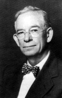
Charles Evans Hughes House is a historic house at 2223 R Street, NW in the Sheridan-Kalorama neighborhood of Washington, D.C. Built in 1907, it was from 1930 to 1948 the home of Charles Evans Hughes (1862–1948), a prominent Republican politician and from 1930 to 1941 the Chief Justice of the United States. It was declared a National Historic Landmark in 1972 and is a contributing property to the Sheridan-Kalorama Historic District. It presently serves as the official residence of the Ambassador of Myanmar to the United States.
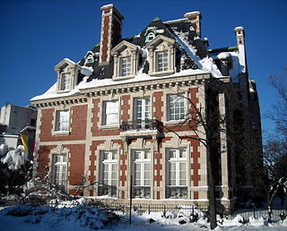
The Thomas T. Gaff House is the diplomatic residence of the Colombian ambassador to the United States, a post currently held by Ambassador Daniel García-Peña, and previously held by Luis Gilberto Murillo. The house, a contributing property to the Dupont Circle Historic District, is located at 1520 20th Street NW, Washington, D.C., across from the north entrance to the metro station in Dupont Circle and one block from Massachusetts Avenue's Embassy Row.

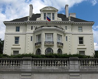
The Embassy of Turkey in Washington, D.C. is the diplomatic mission of the Republic of Turkey to the United States. It is located at 2525 Massachusetts Avenue, Northwest in the Embassy Row neighborhood.

The following outline is provided as an overview of and topical guide to the District of Columbia:

General Philip Sheridan is a bronze sculpture that honors Civil War general Philip Sheridan. The monument was sculpted by Gutzon Borglum, best known for his design of Mount Rushmore. Dedicated in 1908, dignitaries in attendance at the unveiling ceremony included President Theodore Roosevelt, members of the President's cabinet, high-ranking military officers and veterans from the Civil War and Spanish–American War. The equestrian statue is located in the center of Sheridan Circle in the Sheridan-Kalorama neighborhood of Washington, D.C. The bronze statue, surrounded by a plaza and park, is one of eighteen Civil War monuments in Washington, D.C., which were collectively listed on the National Register of Historic Places in 1978. The sculpture and surrounding park are owned and maintained by the National Park Service, a federal agency of the Interior Department.
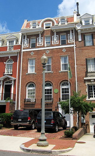
The Embassy of Latvia in Washington, D.C., is the diplomatic mission of the Republic of Latvia to the United States. It is located at 2306 Massachusetts Avenue NW on Embassy Row in the Sheridan-Kalorama neighborhood.

The French ambassador's residence in Washington, D.C. is located at 2221 Kalorama Road, N.W., in the Kalorama neighborhood of Northwest Washington, D.C.

The Embassy of Kenya in Washington, D.C. is the Republic of Kenya's diplomatic mission to the United States, located in the Kalorama neighborhood at 2249 R Street Northwest, Washington, D.C. It is headed by David Kerich.
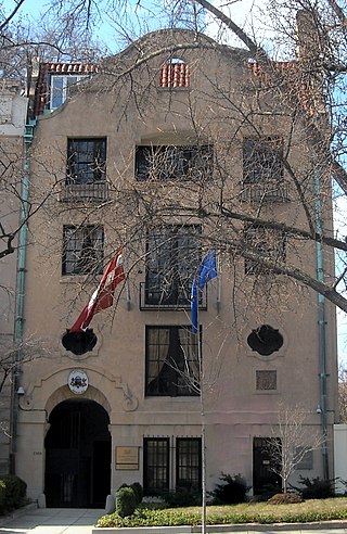
The Embassy of Mauritania in Washington, D.C. is the Islamic Republic of Mauritania's diplomatic mission to the United States. It is located at 2129 Leroy Place N.W. in Washington, D.C.'s Kalorama neighborhood.
The Lothrop Mansion, also known as the Alvin Mason Lothrop House, is an historic home, located at 2001 Connecticut Avenue, Northwest, Washington, D.C., in the Kalorama Triangle neighborhood.

Fuller House is an historic house in the Kalorama Triangle neighborhood of Washington, D.C. It has been listed on the District of Columbia Inventory of Historic Sites since 1985 and it was listed on the National Register of Historic Places in 1985. The house was designed by architect Thomas J.D. Fuller and completed in 1893. It is a contributing property in the Kalorama Triangle Historic District.

The Kalorama Triangle Historic District is a mostly residential neighborhood and a historic district in the northwest quadrant of Washington, D.C. The entire Kalorama Triangle neighborhood was listed on the District of Columbia Inventory of Historic Sites (DCIHS) and National Register of Historic Places (NRHP) in 1987. In addition to individually listed landmarks in the neighborhood, the district is home to roughly 350 contributing properties. The neighborhood is roughly bounded by Connecticut Avenue to the west, Columbia Road to the east, and Calvert Street on the north.
Holmead's Burying Ground, also known as Holmead's Cemetery and the Western Burial Ground, was a historic 2.94-acre (11,900 m2) cemetery located in the Dupont Circle neighborhood of Washington, D.C., in the United States. It was founded by Anthony Holmead in 1794 as a privately owned secular cemetery open to the public. The city of Washington, D.C., constructed the Western Burial Ground on the remainder of the city block in 1798, and the two burial grounds became synonymous. The city took ownership of the private Holmead cemetery in 1820. The unified cemetery went into steep decline around 1850, and it was closed on March 6, 1874. Removal of remains, most of which were reinterred at Graceland Cemetery or Rock Creek Cemetery, continued until 1885.
Arthur B. Heaton was an American architect from Washington, D.C. During his 50-year career Heaton designed over 1,000 commissions, including many notable buildings listed on the National Register of Historic Places (NRHP). He was the first supervising architect of the Washington National Cathedral and one of several local architects responsible for designing many of the buildings in the Burleith, Cleveland Park, Kalorama Triangle, and Woodley Park neighborhoods.

Appleton Prentiss Clark Jr. was an American architect from Washington, D.C. During his 60-year career, Clark was responsible for designing hundreds of buildings in the Washington area, including homes, hotels, churches, apartments and commercial properties. He is considered one of the city's most prominent and influential architects from the late 19th and early 20th centuries. Many of his designs are now listed on the National Register of Historic Places (NRHP).

Decatur Terrace, commonly known as the Spanish Steps, is a terrace in the Kalorama neighborhood of Washington, D.C., located on 22nd Street NW, connecting Decatur Place NW and S Street NW. Formally named Decatur Terrace Steps and Fountain, the nickname is a reference to the Spanish Steps in Rome. Washington's Spanish Steps are listed in the National Register of Historic Places as a contributing feature in the Sheridan-Kalorama Historic District, designated in 1989.

The Sheridan-Kalorama Historic District is a neighborhood and historic district located in the northwest quadrant of Washington, D.C. The boundaries of the historic district include Rock Creek Park to the north and west, P Street to the south, and 22nd Street and Florida Avenue to the east. On the southwestern edge of the neighborhood is a stretch of Embassy Row on Massachusetts Avenue. The other neighborhood and historic district that lies to the east of Sheridan-Kalorama is Kalorama Triangle Historic District. The two neighborhoods are divided by Connecticut Avenue. For many years both neighborhoods were geographically connected before the stretch of Connecticut Avenue was installed toward the Taft Bridge. Oftentimes, both neighborhoods are simply called "Kalorama" or "Kalorama Heights".


