
Grand Canyon Village is a census-designated place (CDP) located on the South Rim of the Grand Canyon, in Coconino County, Arizona, United States. Its population was 2,004 at the 2010 Census. Located in Grand Canyon National Park, it is wholly focused on accommodating tourists visiting the canyon. Its origins trace back to the railroad completed from Williams, to the canyon's South Rim by the Santa Fe Railroad in 1901. Many of the structures in use today date from that period. The village contains numerous landmark buildings, and its historic core is a National Historic Landmark District, designated for its outstanding implementation of town design.
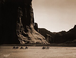
Canyon de Chelly National Monument was established on April 1, 1931, as a unit of the National Park Service. Located in northeastern Arizona, it is within the boundaries of the Navajo Nation and lies in the Four Corners region. Reflecting one of the longest continuously inhabited landscapes of North America, it preserves ruins of the indigenous tribes that lived in the area, from the Ancestral Puebloans to the Navajo. The monument covers 83,840 acres and encompasses the floors and rims of the three major canyons: de Chelly, del Muerto, and Monument. These canyons were cut by streams with headwaters in the Chuska Mountains just to the east of the monument. None of the land is federally owned. Canyon de Chelly is one of the most visited national monuments in the United States.

The National Register of Historic Places in the United States is a register including buildings, sites, structures, districts, and objects. The Register automatically includes all National Historic Landmarks as well as all historic areas administered by the U.S. National Park Service. Since its introduction in 1966, more than 90,000 separate listings have been added to the register.
The Niles Canyon Railway (NCRy) is a heritage railway running on the first transcontinental railroad alignment through Niles Canyon, between Sunol and the Niles district of Fremont in the East Bay of the San Francisco Bay Area, in California, United States. The railway is listed on the National Register of Historic Places as the Niles Canyon Transcontinental Railroad Historic District. The railroad is operated and maintained by the Pacific Locomotive Association which preserves, restores and operates historic railroad equipment. The NCRy features public excursions with both steam and diesel locomotives along a well-preserved portion of the first transcontinental railroad.

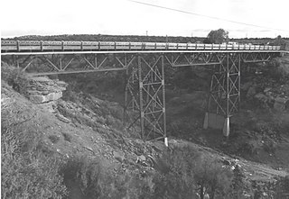
The D&RG Narrow Gauge Trestle, also known as the Cimarron Canyon trestle, is a narrow-gauge railroad deck truss bridge crossing the Cimarron River near Cimarron, Colorado. Located within the Curecanti National Recreation Area, the trestle is the last remaining railroad bridge along the Denver & Rio Grande Railroad's Black Canyon route, a narrow-gauge passenger and freight line that traversed the famous Black Canyon of the Gunnison between 1882 and the 1940s.

The Jackson Branch Bridge No. 15, also known as the Tecumseh Railroad Bridge due to its close proximity to the city of Tecumseh, is a historic railway deck truss bridge that spans the River Raisin in rural Raisin Charter Township in Lenawee County, Michigan. The bridge was added to the National Register of Historic Places on December 4, 2001.

The Canyon Falls Bridge is a bridge located on US Highway 41 (US 41) over the Sturgeon River in L'Anse Township, Michigan. It was listed on the National Register of Historic Places in 1999.

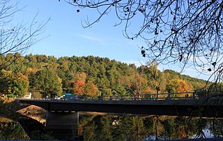
The Middlesex–Winooski River Bridge is a steel girder bridge carrying U.S. Route 2 (US 2) across the Winooski River in a rural area on the town line between Moretown and Middlesex, Vermont. The two-span bridge was built in 2010, replacing a 1928 three-span Pratt through truss, which was listed on the National Register of Historic Places in 1991.
The West Milton Bridge is a steel girder bridge carrying Bear Trap Road across the Lamoille River in Milton, Vermont, United States. It was built as a replacement for a 1902 Pennsylvania truss bridge, which was relocated to the site of the Swanton Covered Railroad Bridge, and is listed on the National Register of Historic Places.
The Querino Canyon Bridge is located approximately four miles (6.4 km) southwest of Houck, Arizona, on Old Route 66, over Querino Canyon.

The Fort Sumner Railroad Bridge, over the Pecos River 2 miles (3.2 km) west of Fort Sumner, New Mexico, was built in 1905. It was listed on the National Register of Historic Places in 1979.
Fort McRae was a Union Army post, established in 1863, then a U.S. Army post from 1866 and closed in 1876, in what is now Sierra County, New Mexico. The post was named for Alexander McRae (1829–1862) a slain hero of the 1862 Battle of Valverde.
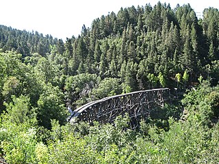
Mexican Canyon Trestle is a historic wooden trestle bridge in New Mexico's Sacramento Mountains, Otero County, New Mexico, just outside Cloudcroft, New Mexico. It was listed on the National Register of Historic Places in 1979.

