Related Research Articles

San Luis Obispo County, officially the County of San Luis Obispo, is a county on the Central Coast of California. As of the 2020 census, the population was 282,424. The county seat is San Luis Obispo.
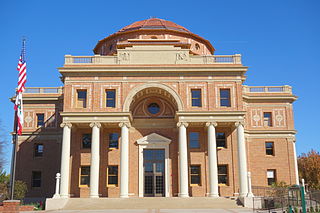
Atascadero is a city in San Luis Obispo County, California, United States, located on U.S. Route 101. Atascadero is part of the San Luis Obispo-Paso Robles metropolitan statistical area, which encompasses the extents of the county. Atascadero is farther inland than most other cities in the county, and as a result, usually experiences warmer, drier summers, and cooler winters than other nearby cities such as San Luis Obispo and Pismo Beach. The main freeway through town is U.S. 101. The nearby State Routes 41 and 46 provide access to the Pacific Coast and the Central Valley of California.

San Luis Obispo is a city and county seat of San Luis Obispo County, in the U.S. state of California. Located on the Central Coast of California, San Luis Obispo is roughly halfway between the San Francisco Bay Area in the north and Greater Los Angeles in the south. The population was 47,063 at the 2020 census.

Milan is the second largest city after Humboldt in Gibson County, Tennessee and the largest entirely within the county. It is home to the Milan Army Ammunition Plant, the West Tennessee Agricultural Museum and several historical sites listed on the National Register of Historic Places (NRHP). The city was the first in Tennessee to begin no-till farming and to fluoridate its drinking water. The Milan Endowment for Growth in Academics (MEGA) was the first private community financial endowment for public schools in Tennessee.
The Commonwealth War Graves Commission (CWGC) is an intergovernmental organisation of six independent member states whose principal function is to mark, record and maintain the graves and places of commemoration of Commonwealth of Nations military service members who died in the two World Wars. The commission is also responsible for commemorating Commonwealth civilians who died as a result of enemy action during the Second World War. The commission was founded by Sir Fabian Ware and constituted through Royal Charter in 1917 as the Imperial War Graves Commission. The change to the present name took place in 1960.

Angel Mounds State Historic Site, an expression of the Mississippian culture, is an archaeological site managed by the Indiana State Museum and Historic Sites that includes more than 600 acres of land about 8 miles (13 km) southeast of present-day Evansville, in Vanderburgh and Warrick counties in Indiana. The large residential and agricultural community was constructed and inhabited from AD 1100 to AD 1450, and served as the political, cultural, and economic center of the Angel chiefdom. It extended within 120 miles (190 km) of the Ohio River valley to the Green River in present-day Kentucky. The town had as many as 1,000 inhabitants inside the walls at its peak, and included a complex of thirteen earthen mounds, hundreds of home sites, a palisade (stockade), and other structures.

Topper is an archaeological site located along the Savannah River in Allendale County, South Carolina, United States. It is noted as a location of artifacts which some archaeologists believe to indicate human habitation of the New World earlier than the Clovis culture. The latter were previously believed to be the first people in North America.

The Koster Site is a prehistoric archaeological site located south of Eldred, Illinois. The site covers more than 3 acres and extends 30 feet down into the alluvial deposits of the Illinois River valley. Over the course of its excavation between 1969 and 1978, Koster produced deeply buried evidence of ancient human occupation from the early Archaic period to the Mississippian period. The soil strata contains a total of 25 distinct occupations each separated by additional layers of soil, making the site exceptionally well-preserved.

Fort Rock Cave was the site of the earliest evidence of human habitation in the US state of Oregon before the excavation of Paisley Caves. Fort Rock Cave featured numerous well-preserved sagebrush sandals, ranging from 9,000 to 13,000 years old. The cave is located approximately 1.5 miles (2.4 km) west of Fort Rock near Fort Rock State Natural Area in Lake County. Fort Rock Cave was declared a National Historic Landmark in 1961, and added to the National Register of Historic Places in 1966.
Grand Village of the Natchez, also known as the Fatherland Site, is a 128.1-acre (0.518 km2) site encompassing a prehistoric indigenous village and earthwork mounds in present-day south Natchez, Mississippi. The village complex was constructed starting about 1200 CE by members of the prehistoric Plaquemine culture. They built the three platform mounds in stages. Another phase of significant construction work by these prehistoric people has been dated to the mid-15th century. It was named for the historic Natchez people, who used the site in the 17th and 18th centuries.

Azykh Cave, also referred to as Azokh Cave, is a six-cave complex in Azerbaijan, known as a habitation site of prehistoric humans. It is situated near the village of Azykh in the Khojavend District.

The Marmes Rockshelter is an archaeological site first excavated in 1962, near Lyons Ferry Park and the confluence of the Snake and Palouse Rivers, in Franklin County, southeastern Washington. This rockshelter is remarkable in the level of preservation of organic materials, the depth of stratified deposits, and the apparent age of the associated Native American human remains. The site was discovered on the property of Roland Marmes, and was the site of the oldest human remains in North America at that time. In 1966, the site became, along with Chinook Point and the American and English Camps on San Juan Island, the first National Historic Landmarks listed in Washington. In 1969, the site was submerged in water when a levee protecting it from waters rising behind the then newly constructed Lower Monumental Dam, which was 20 miles (32 km) down the Snake River, failed to hold back water that leaked into the protected area through gravel under the soil, creating Lake Herbert G. West.

Archaeology or archeology is the study of human activity through the recovery and analysis of material culture. The archaeological record consists of artifacts, architecture, biofacts or ecofacts, sites, and cultural landscapes. Archaeology can be considered both a social science and a branch of the humanities. It is usually considered an independent academic discipline, but may also be classified as part of anthropology, history or geography.
The Con Moong cave is located in the Cúc Phương National Park, just south of Mọ village, in the Thanh Hóa Province, northern Vietnam. The Department of Culture has issued a certificate that declares Con Moong prehistoric site and its surroundings as National Relics and is managed by the Cúc Phương National Park administration, along with a refuge for rare animals. Among these locations, the archaeological site of Con Moong cave is of central importance for the study of the Mesolithic Hoabinhian culture. In April and May 1976, Vietnamese archaeologists excavated the site.

Poverty Point State Historic Site/Poverty Point National Monument is a prehistoric earthwork constructed by the Poverty Point culture, located in present-day northeastern Louisiana. Evidence of the Poverty Point culture extends throughout much of the Southeastern Woodlands of the Southern United States. The culture extended 100 miles (160 km) across the Mississippi Delta and south to the Gulf Coast.

The Wright-Patterson Air Force Base Mound, designated 33GR31, is a Native American mound near the city of Dayton in Greene County, Ohio, United States. Named for its location on an Air Force facility, Wright-Patterson Air Force Base, the mound is an archaeological site.
Walter Danforth Bliss (1874-1956) was an American architect from California. Many of his buildings are listed on the National Register of Historic Places.
The Central Coast Athletic Association (CCAA) is a high school athletic conference in California that is affiliated with the CIF Central Section. The association was established in 2018 as the Central Coast Athletic Conference and consists of 16 schools in San Luis Obispo and Santa Barbara counties that previously were members of the CIF Southern Section and three of its constituent conferences, the Pac-8, the Los Padres League, and the Channel League.

The Atascadero Printery is a historic building in Atascadero, California. Built in 1915 to house a printing company, it later was home to a junior college, a prep school, a Masonic Temple, a school district office, a sheriff's substation, a live-in studio for a photographer, a karate studio, a commercial business, and community events. In 2017, the building, in a state of disrepair, was put up for public auction and purchased for $300,000 by the non-profit Atascadero Printery Foundation, which plans to restore and remodel it as a community center.
References
- ↑ "National Register Information System". National Register of Historic Places . National Park Service. July 9, 2010.
- ↑ Farquhar, Jennifer (2008), Cultural Resources Survey Report for the Water Treatment Plant Initial Study, Padre Associates, p. 15, archived from the original on March 4, 2016, retrieved April 22, 2013
- ↑ "Notice of Intention to Adopt Proposed Mitigated Negative Declaration" (PDF). City of Atascadero. September 14, 2011. p. 17. Retrieved April 22, 2013.[ permanent dead link ]
| Topics | |
|---|---|
| Lists by state |
|
| Lists by insular areas | |
| Lists by associated state | |
| Other areas | |
| Related | |
| | This article about a property in San Luis Obispo County, California on the National Register of Historic Places is a stub. You can help Wikipedia by expanding it. |