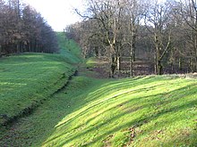
The course of the Antonine Wall, at Bar Hill, the largest single Roman built structure in the modern borders of Scotland
The architecture of Scotland in the Roman era includes all building within the modern borders of Scotland, from the arrival of the Romans in northern Britain in the first century BCE, until their departure in the fifth century CE. Ptolemy indicated that there were 19 "towns" in Caledonia, north of the Roman province of Britannia, but no clear evidence of urban settlements has been found and these were probably hillforts. There is evidence of over 1,000 such forts, most south of the Clyde-Forth line, but the majority seem to have been abandoned in the Roman period. There is also evidence of distinctive stone wheelhouses and small underground souterrains.
From about 71 CE the Romans began military expeditions into what is now Scotland, building forts, like that at Trimontium, and probably pushing north as far as the River Tay where they created more fortifications, like those at Inchtuthil. These were soon abandoned, and the Romans settled for the occupation of the Southern Uplands by the end of the first century, south of a line drawn between the Tyne and Solway Firth. This resulted in more fortifications and the building of Hadrian's Wall across what is now northern England. Around 141 CE they moved up to construct a new limes, a sward-covered wall made of turf known as the Antonine Wall, the largest Roman structure in modern Scotland. They soon retreated to Hadrian's Wall, with occasional expeditions that involved the building and reoccupation of forts, until the collapse of Roman power in the early fifth century.
Caledonia was the name that the Romans gave to the land north of their province of Britannia. In his Geographia, Ptolemy, possibly drawing on earlier sources of information as well as more contemporary accounts from the Agricolan invasion, identified 19 "towns" in Caledonia. No archaeological evidence of any truly urban places has been found from this time, and the names may have indicated hill forts, temporary markets or meeting places. Most of the names are obscure: Devana may be the modern Banchory, Alauna (meaning "the rock") in the west is probably Dumbarton Rock and the place of the same name in the east of the Lowlands may be the site of Edinburgh Castle. Lindon may be Balloch on Loch Lomond side.[1] There is evidence for about 1,000 Iron Age hillforts in Scotland, most located below the Clyde-Forth line.[2] The majority are circular, with a single palisade around an enclosure.[2] However, they appear to have been largely abandoned in the Roman period.[3] There are also numerous vitrified forts, whose walls have been subjected to fire, which may date to this period, but an accurate chronology has not been created. Extensive studies of this type of fort at Finavon Hill near Forfar in Angus, suggest dates for the destruction of the site in either the last two centuries BCE, or the mid-first millennium CE.[4] Many of these forts were reoccupied after the Roman departure.[3]
Beyond the area of Roman occupation, in the west and north, there are over 60 sites identified of wheelhouses. Perhaps a development of earlier Atlantic roundhouses, these have a characteristic outer wall surrounding a circle of stone piers (bearing a resemblance to the spokes of a wheel).[5] Over 400 souterrains, small underground constructions, have been discovered in Scotland, many of them in the south-east, and although few have been dated, those that have suggest a construction date in the second or third centuries CE. They are usually found close to settlements (whose timber frames are much less well-preserved) and may have been for storing perishable agricultural products.[6]
The Romans began military expeditions into what is now Scotland from about 71 CE. In 78 CE Gnaeus Julius Agricola arrived in Britain as the new governor and began a series of major incursions. Two years later his legions constructed a substantial fort at Trimontium near Melrose. He is said to have pushed his armies to the estuary of the "River Taus" (usually assumed to be the River Tay) and established forts there, including a legionary fortress at Inchtuthil. After his victory over the northern tribes at Mons Graupius in 84 CE, a series of forts and towers were established along the Gask Ridge, which marked the boundary between the Lowland and Highland zones, probably forming the first Roman limes or frontier in Scotland.[7]
Agricola's successors were unable or unwilling to further subdue the far north. The fortress at Inchtuthil was dismantled before its completion, and the other fortifications of the Gask Ridge were abandoned within a few years.[7] By 87 CE the occupation was limited to the Southern Uplands, and by the end of the first century the northern limit of Roman expansion was a line drawn between the Tyne and the Solway Firth.[8]Elginhaugh fort, in Midlothian, dates to about this period, as may Castle Greg in West Lothian. The Romans eventually withdrew to a line in what is now northern England, building the fortification known as Hadrian's Wall from coast to coast.[9]
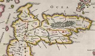
Around 141 CE the Romans undertook a reoccupation of southern Scotland, moving up to construct a new limes between the Firth of Forth and the Firth of Clyde. The resulting Antonine Wall is the largest Roman construction inside Scotland. It is a sward-covered wall made of turf, around 20 feet (6m) high, with nineteen forts and extending for 37 miles (60km).[9][10] The stone foundations and wing walls of the original forts demonstrate that the intention was to build a stone wall similar to Hadrian's Wall, but this was quickly amended. There is a wide ditch on the north side, and a military way on the south. The Romans initially planned to build forts every 6 miles (10km), but this was soon revised to every 2 miles (3km). One of the best preserved forts, but also one of the smallest, is Rough Castle Fort. In addition to the forts, there are at least nine smaller fortlets, probably on Roman mile spacings, which formed part of the original scheme, some of which were later replaced by forts.[11] The most visible fortlet is Kinneil, at the eastern end of the Wall, near Bo'ness.[12] Having taken twelve years to build, the wall was overrun and abandoned soon after 160 CE.[9][10] The Romans retreated to the line of Hadrian's Wall.[13]
Roman troops penetrated far into the north of modern Scotland several more times, with at least four major campaigns. The Antonine Wall was occupied again for a brief period after 197 CE.[14] The most notable invasion was in 209 when the emperor Septimius Severus led a major campaign. A string of forts was constructed in the north-east (some of which may have been begun in the earlier Antonine campaign). These include camps associated with the Elsick Mounth, such as Normandykes, Ythan Wells, Deers Den and Glenmailen.[15] Only two forts in Scotland, at Cramond and Carpow (in the Tay valley) are definitely known to have been permanently occupied during this incursion.[16] There is evidence that these campaigns are coincident with the wholesale destruction and abandonment of souterrains in southern Scotland. This may have been due either to Roman military aggression or the collapse of local grain markets in the wake of Roman withdrawal.[17] After the death of Severus in 210 the Romans withdrew back to Hadrian's Wall, which would be the frontier until Roman authority in Britain collapsed in the fifth century.[16]
↑ A. Moffat, Before Scotland: The Story of Scotland Before History (London: Thames and Hudson, 2005), ISBN0-500-28795-3, pp. 268–70.
1 2 J-D. G. G. Lepage, British Fortifications Through the Reign of Richard III: An Illustrated History (McFarland, 2012), ISBN0-7864-5918-2, pp. 25 and 31.
1 2 A. Konstam, Strongholds of the Picts: The Fortifications of Dark Age Scotland (Botley: Osprey, 2010), ISBN1-84603-686-0, p. 12.
↑ D. Alexander, "The oblong fort at Finavon, Angus" in B. B. Smith and I. Banks, eds, In the Shadow of the Brochs (Stroud: Tempus, 2002), ISBN0-7524-2517-X, pp.45–54.
↑ I. Crawford, "The wheelhouse" in B. B. Smith and I. Banks, eds, In the Shadow of the Brochs (Stroud: Tempus, 2002), ISBN0-7524-2517-X, pp.127–28.
↑ R. Miket, "The souterrains of Skye" in B. B. Smith and I. Banks, eds, In the Shadow of the Brochs (Stroud: Tempus, 2002), ISBN0-7524-2517-X, pp.77–110.
1 2 A. Moffat, Before Scotland: The Story of Scotland Before History (London: Thames and Hudson, 2005), ISBN0-500-28795-3, p. 245.
↑ W. S. Hanson, "The Roman Presence: Brief Interludes", in K. J. Edwards, I. B. M. Ralston, eds, Scotland After the Ice Age: Environment, Archaeology and History, 8000 BC– AD 1000 (Edinburgh. Edinburgh University Press, 2003), ISBN0-7486-1736-1, p. 195.
1 2 W. S. Hanson, "The Roman Presence: Brief Interludes", in K. J. Edwards, I. B. M. Ralston, eds, Scotland After the Ice Age: Environment, Archaeology and History, 8000 BC– AD 1000 (Edinburgh. Edinburgh University Press, 2003), ISBN0-7486-1736-1, p. 198.
↑ R. Miket, "The souterrains of Skye" in B. B. Smith and I. Banks, eds, In the Shadow of the Brochs (Stroud: Tempus, 2002), ISBN0-7524-2517-X, pp.82.
In archaeology, a broch is an Iron Age drystone hollow-walled structure found in Scotland. Brochs belong to the classification "complex Atlantic roundhouse" devised by Scottish archaeologists in the 1980s.
Trimontium was a Roman fort complex located at Newstead, near Melrose, in the Scottish Borders, in view of the three Eildon Hills which probably gave its name.
Jarlshof is the best-known prehistoric archaeological site in Shetland, Scotland. It lies in Sumburgh, Mainland, Shetland and has been described as "one of the most remarkable archaeological sites ever excavated in the British Isles". It contains remains dating from 2500 BC up to the 17th century AD.
The Gask Ridge is the modern name given to an early series of fortifications, built by the Romans in Scotland, close to the Highland Line. Modern excavation and interpretation has been pioneered by the Roman Gask Project, with Birgitta Hoffmann and David Woolliscroft. The ridge fortifications: forts, fortlets and watchtowers were only in operation for a few years, probably fewer than ten.
Broch of Mousa is a preserved Iron Age broch or round tower. It is on the island of Mousa in Shetland, Scotland. It is the tallest broch still standing and amongst the best-preserved prehistoric buildings in Europe. It is thought to have been constructed c. 300 BC, and is one of more than 500 brochs built in Scotland. The site is managed by Historic Environment Scotland as a scheduled monument.
Scotland during the Roman Empire refers to the protohistorical period during which the Roman Empire interacted within the area of modern Scotland. Despite sporadic attempts at conquest and government between the first and fourth centuries AD, most of modern Scotland, inhabited by the Caledonians and the Maeatae, was not incorporated into the Roman Empire with Roman control over the area fluctuating.
In archaeology, a wheelhouse is a prehistoric structure from the Iron Age found in Scotland. The term was first coined after the discovery of a ruined mound in 1855. The distinctive architectural form related to the complex roundhouses constitute the main settlement type in the Western Isles in the closing centuries BC. A total of 62 sites have now been identified in the Northern and Western Isles, and on the north coast of Caithness and Sutherland.
The Antonine Wall was a turf fortification on stone foundations, built by the Romans across what is now the Central Belt of Scotland, between the Firth of Clyde and the Firth of Forth. Built some twenty years after Hadrian's Wall to the south, and intended to supersede it, while it was garrisoned it was the northernmost frontier barrier of the Roman Empire. It spanned approximately 63 kilometres and was about 3 metres high and 5 metres wide. Lidar scans have been carried out to establish the length of the wall and the Roman distance units used. Security was bolstered by a deep ditch on the northern side. It is thought that there was a wooden palisade on top of the turf. The barrier was the second of two "great walls" created by the Romans in Great Britain in the second century AD. Its ruins are less evident than those of the better-known and longer Hadrian's Wall to the south, primarily because the turf and wood wall has largely weathered away, unlike its stone-built southern predecessor.
Inverquharity is a Roman fortlet in Scotland, close to the Highland Line about 5 miles (8 km) north of Kirriemuir, Angus.
The architecture of Scotland includes all human building within the modern borders of Scotland, from the Neolithic era to the present day. The earliest surviving houses go back around 9500 years, and the first villages 6000 years: Skara Brae on the Mainland of Orkney being the earliest preserved example in Europe. Crannogs, roundhouses, each built on an artificial island, date from the Bronze Age and stone buildings called Atlantic roundhouses and larger earthwork hill forts from the Iron Age. The arrival of the Romans from about 71 AD led to the creation of forts like that at Trimontium, and a continuous fortification between the Firth of Forth and the Firth of Clyde known as the Antonine Wall, built in the second century AD. Beyond Roman influence, there is evidence of wheelhouses and underground souterrains. After the departure of the Romans there were a series of nucleated hill forts, often utilising major geographical features, as at Dunadd and Dunbarton.
Prehistoric Shetland refers to the prehistoric period of the Shetland archipelago of Scotland, when it was first occupied by humans. The period prior to human settlement in Shetland is known as the geology of Scotland. Prehistory in Shetland does not end until the beginning of the Early Medieval Period in Scotland, around AD 600. More than 5,000 archaeological sites have been recorded in the Shetland Islands.
The architecture of Scotland in the Middle Ages includes all building within the modern borders of Scotland, between the departure of the Romans from Northern Britain in the early fifth century and the adoption of the Renaissance in the early sixteenth century, and includes vernacular, ecclesiastical, royal, aristocratic and military constructions. The first surviving houses in Scotland go back 9500 years. There is evidence of different forms of stone and wooden houses exist and earthwork hill forts from the Iron Age. The arrival of the Romans led to the abandonment of many of these forts. After the departure of the Romans in the fifth century, there is evidence of the building of a series of smaller "nucleated" constructions sometimes utilizing major geographical features, as at Dunadd and Dumbarton. In the following centuries new forms of construction emerged throughout Scotland that would come to define the landscape.
The architecture of Scotland in the prehistoric era includes all human building within the modern borders of Scotland, before the arrival of the Romans in Britain in the first century BCE. Stone Age settlers began to build in wood in what is now Scotland from at least 8,000 years ago. The first permanent houses of stone were constructed around 6,000 years ago, as at Knap of Howar, Orkney and settlements like Skara Brae. There are also large numbers of chambered tombs and cairns from this era, particularly in the west and north. In the south and east there are earthen barrows, often linked to timber monuments of which only remnants remain. Related structures include bank barrows, cursus monuments, mortuary enclosures and timber halls. From the Bronze Age there are fewer new buildings, but there is evidence of crannogs, roundhouses built on artificial islands and of Clava cairns and the first hillforts. From the Iron Age there is evidence of substantial stone Atlantic roundhouses, which include broch towers, smaller duns. There is also evidence of about 1,000 hillforts in Scotland, most located below the Clyde-Forth line.
Hillforts in Scotland are earthworks, sometimes with wooden or stone enclosures, built on higher ground, which usually include a significant settlement, built within the modern boundaries of Scotland. They were first studied in the eighteenth century and the first serious field research was undertaken in the nineteenth century. In the twentieth century there were large numbers of archaeological investigations of specific sites, with an emphasis on establishing a chronology of the forts. Forts have been classified by type and their military and ritual functions have been debated.
The demographic history of Scotland includes all aspects of population history in what is now Scotland. The earliest surviving archaeological evidence of human settlement is of Mesolithic hunter-gatherer encampments. These suggest a highly mobile boat-using people, probably with a very low density of population. Neolithic farming brought permanent settlements dating from 3500 BC, and greater concentrations of population. Evidence of hillforts and other buildings suggest a growing settled population. Changes in the scale of woodland indicates that the Roman invasions from the first century AD had a negative impact on the native population.
Prehistoric art in Scotland is visual art created or found within the modern borders of Scotland, before the departure of the Romans from southern and central Britain in the early fifth century CE, which is usually seen as the beginning of the early historic or Medieval era. There is no clear definition of prehistoric art among scholars and objects that may involve creativity often lack a context that would allow them to be understood.
Housing in Scotland includes all forms of built habitation in what is now Scotland, from the earliest period of human occupation to the present day. The oldest house in Scotland dates from the Mesolithic era. In the Neolithic era settled farming led to the construction of the first stone houses. There is also evidence from this period of large timber halls. In the Bronze Age there were cellular round crannogs and hillforts that enclosed large settlements. In the Iron Age cellular houses begin to be replaced on the northern isles by simple Atlantic roundhouses, substantial circular buildings with a drystone construction. The largest constructions that date from this era are the circular brochs and duns and wheelhouses.
Agriculture in prehistoric Scotland includes all forms of farm production in the modern boundaries of Scotland before the beginning of the early historic era. Scotland has between a fifth and a sixth of the arable or good pastoral land of England and Wales, mostly in the south and east. Heavy rainfall encouraged the spread of acidic blanket peat bog, which with wind and salt spray, made most of the western islands treeless. Hills, mountains, quicksands and marshes made internal communication and agriculture difficult.
The frontier of the Roman Empire in Britain is sometimes styled Limes Britannicus by authors for the boundaries, including fortifications and defensive ramparts, that were built to protect Roman Britain. These defences existed from the 1st to the 5th centuries AD and ran through the territory of present-day England, Scotland and Wales.
Scotland in the Iron Age concerns the period of prehistory in Scotland from about 800 BCE to the commencement of written records in the early Christian era. As the Iron Age emerged from the preceding Bronze Age, it becomes legitimate to talk of a Celtic culture in Scotland. It was an age of forts and farmsteads, the most dramatic remains of which are brochs some of whose walls still exceed 6.5 m (21 ft) in height. Pastoral farming was widespread but as the era progressed there is more evidence of cereal growing and increasing intensification of agriculture. Unlike the previous epochs of human occupation, early Iron Age burial sites in Scotland are relatively rare although monasteries and other religious sites were constructed in the last centuries of the period. The Stirling torcs are amongst examples of high quality crafts produced at an early date and the Pictish symbol stones are emblematic of later times.
This page is based on this Wikipedia article Text is available under the CC BY-SA 4.0 license; additional terms may apply. Images, videos and audio are available under their respective licenses.