Armour, Ontario

Last updated

Armour
Township of Armour
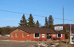
Armour Twp ON.JPG
Municipal office
Etymology: John Douglas Armour. [1]
Canada Southern Ontario location map 2.png
Red pog.svg
Armour
Location in Southern Ontario
Coordinates: 45°37′44″N79°20′38″W / 45.62889°N 79.34389°W / 45.62889; -79.34389 [2]
Country Canada
Province Ontario
District Parry Sound
Incorporated1998 (1998)
Government
  TypeTownship
  MayorRod Ward
   MP Scott Aitchison (CPC)
   MPP Graydon Smith (OPC)
Area
[3]
  Land163.52 km2 (63.14 sq mi)
Population
 (2021) [4]
  Total1,459
  Density8.9/km2 (23/sq mi)
Time zone UTC-5 (EST)
  Summer (DST) UTC-4 (EDT)
Postal code span
P0A
Area codes 705, 249
Website www.armourtownship.ca OOjs UI icon edit-ltr-progressive.svg

Armour (2021 population 1,459) is a township municipality in the Canadian province of Ontario. [2] [5] [6]

Contents

Located in the Almaguin Highlands region of Parry Sound District, the township surrounds but does not include the village of Burk's Falls. It was named in honour of Judge John Douglas Armour. [1]

Communities

The township includes the communities of Berriedale, Carss, Chetwynd, Katrine and Pickerel Lake.

Katrine overlooks Doe Lake, which is located on the west side of the village. Three Mile Lake and Deer Lake are located about 5 km east of the village. There is also a small public beach on Doe Lake, and a community centre located on Ontario Highway 11. [7]

Demographics

Armour, Ontario historical populations
YearPop.±%
19911,403    
1996 1,464+4.3%
2001 1,326−9.4%
2006 1,249−5.8%
2011 1,372+9.8%
2016 1,414+3.1%
2021 1,459+3.2%
[8] [3] [9]

In the 2021 Census of Population conducted by Statistics Canada, Armour had a population of 1,459 living in 667 of its 1,087 total private dwellings, a change of

Mother tongue (2006): [11]

See also

Related Research Articles

<span class="mw-page-title-main">Parry Sound District</span> District in Ontario, Canada

Parry Sound District is a census division of the Canadian province of Ontario. Its boundaries are District of Muskoka to the south, the Sudbury District to the north-northwest, the French River and Lake Nipissing in the north, Nipissing District and North Bay in the north and east and parts of Algonquin Park in the northeast.

<span class="mw-page-title-main">Restoule</span> Designated place with Local Services Board in Ontario, Canada

Restoule is a community and designated place in geographic Patterson Township in the Centre Unorganized Part of Parry Sound District in Central Ontario, Canada. It is situated on the Restoule River between Commanda Lake, and Restoule Lake and is part of the Almaguin Highlands region.

<span class="mw-page-title-main">South Frontenac</span> Township in Ontario, Canada

South Frontenac is a township in Frontenac County in eastern Ontario, Canada. It was amalgamated in 1998 from the former townships of Bedford, Loughborough, Portland, and Storrington.

<span class="mw-page-title-main">Burk's Falls</span> Village in Ontario, Canada

Burk's Falls is an incorporated village in the Almaguin Highlands region of Parry Sound District, Ontario, Canada, located 265 kilometres (165 mi) north of Toronto and 90 kilometres (56 mi) south of North Bay, Ontario. The village, and the waterfall on the site, were named by David Francis Burk of Oshawa, after he selected the land surrounding the waterfall in the Free Land Grant Act. Burk's Falls is part of the Magnetawan River waterway.

<span class="mw-page-title-main">Nipissing, Ontario</span> Township in Ontario, Canada

Nipissing is an incorporated (political) township in Parry Sound District in Central Ontario, Canada. It is on Lake Nipissing and is part of the Almaguin Highlands region. Nipissing was surveyed between 1874 and 1881, and was incorporated in 1888. Among the first settlers in the area were the Chapman and Beatty families. Nipissing Township annexed Gurd Township in 1970. The township also contains a community named Nipissing, which is located on the South River near Chapman's Landing, on the South Bay of Lake Nipissing. The township administrative offices are located in Nipissing.

<span class="mw-page-title-main">South River, Ontario</span> Village in Ontario, Canada

South River is a village on Highway 124 near Algonquin Park in the Almaguin Highlands region of Parry Sound District of Ontario, Canada. It is about halfway between North Bay and Huntsville or a 3-hour drive (300 km) north from Toronto. South River has access to the Algonquin Park for canoeists at Kawawaymog. South River is home of Mikisew Provincial Park on the shores of Eagle Lake.

<span class="mw-page-title-main">Magnetawan</span> Municipality in Ontario, Canada

Magnetawan is a township in the Almaguin Highlands region of the Parry Sound District in the Canadian province of Ontario, as well as the name of the primary population centre in the township.

Machar is a township in the Canadian province of Ontario.

<span class="mw-page-title-main">Strong, Ontario</span> Township in Ontario, Canada

Strong is a township in the Canadian province of Ontario, as well as the name of a community within the township. Located in the Almaguin Highlands region of Parry Sound District, the township surrounds but does not include the village of Sundridge.

<span class="mw-page-title-main">Perry, Ontario</span> Township in Ontario, Canada

Perry is a township in the Canadian province of Ontario, located in the Almaguin Highlands region of Parry Sound District.

<span class="mw-page-title-main">Ryerson, Ontario</span> Township in Ontario, Canada

Ryerson is an incorporated township in the Almaguin Highlands region of Parry Sound District in northeastern Ontario, Canada. It had a population of 745 in the 2021 Canadian census. It was named after Egerton Ryerson, the Chief Superintendent of Education for Ontario from 1844 to 1876.

<span class="mw-page-title-main">Joly, Ontario</span> Township in Ontario, Canada

Joly is a township in the Almaguin Highlands region of Parry Sound District of the Canadian province of Ontario.

<span class="mw-page-title-main">Fauquier-Strickland</span> Township in Ontario, Canada

Fauquier-Strickland is a township municipality in Cochrane District in Northeastern Ontario, Canada. The three main communities in the township are Fauquier, Strickland, and Gregoires Mill. All are located along Ontario Highway 11 between the community of Departure Lake to the east and the municipality of Moonbeam to the west.

<span class="mw-page-title-main">Val Rita-Harty</span> Township municipality in Ontario, Canada

Val Rita-Harty is a township municipality in Cochrane District in Northeastern Ontario, Canada.

<span class="mw-page-title-main">McMurrich/Monteith</span> Township in Ontario, Canada

McMurrich/Monteith is a municipality and census subdivision in the Almaguin Highlands region of Parry Sound District, Ontario, Canada.

<span class="mw-page-title-main">Algonquin Highlands</span> Township in Ontario, Canada

Algonquin Highlands is a township located in Haliburton County, Ontario, Canada. It has a population of 2,351. The northeastern section of the township is included in Algonquin Provincial Park.

<span class="mw-page-title-main">Coleman, Ontario</span> Township municipality in Ontario, Canada

Coleman is a township municipality in the Canadian province of Ontario. It is situated in the Timiskaming District of Northeastern Ontario. The township had a population of 595 in the Canada 2016 Census.

<span class="mw-page-title-main">James, Ontario</span> Township in Ontario, Canada

James is an incorporated township in the Canadian province of Ontario, located in Timiskaming District. The primary community within the township is Elk Lake, which is located at the junction of Ontario Highway 65 and Ontario Highway 560.

Unorganized North East Parry Sound District is an unorganized area in Parry Sound District in Central Ontario, Canada. It is served by the local services board of Laurier and is part of the Almaguin Highlands region. The region had a population of 179 in the Canada 2021 Census, and a land area of 183.04 square kilometres.

<span class="mw-page-title-main">Almaguin Highlands</span> Inter-region in Ontario, Canada

The Almaguin Highlands Region in Ontario, Canada, covers approximately 5,200 km2 (2,000 sq mi) comprising the eastern half of Parry Sound District. It is bounded by Muskoka in the south, and by Lake Nipissing and Nipissing District in the north. The eastern edge abuts the western boundary of Algonquin Provincial Park, whereas the western boundary of the Almaguin Highlands is generally regarded to be the mid east-west point of Parry Sound District. Originally derived from the words Algonquin, Magnetawan, and Seguin. the name Almaguin is now used to describe the marketing region of East Parry Sound.

References

  1. 1 2 "The Honourable Mr. Justice John Douglas Armour". Township of Armour. Archived from the original on 2011-07-06. Retrieved 2010-08-17.
  2. 1 2 "Armour". Geographical Names Data Base . Natural Resources Canada . Retrieved 2021-01-09.
  3. 1 2 Statistics Canada 2011 Census - Armour Census Profile
  4. "Census Profile, 2021 Census: Armour, Township". Statistics Canada. Retrieved February 9, 2022.
  5. "Ontario Geonames GIS (on-line map and search)". Ontario Ministry of Natural Resources and Forestry. 2014. Retrieved 2021-01-09.
  6. Restructured municipalities - Ontario map #4 (Map). Restructuring Maps of Ontario. Ontario Ministry of Municipal Affairs and Housing. 2006. Archived from the original on 2014-04-10. Retrieved 2021-01-09.
  7. "Katrine Ontario". Almaguin Communities. Almaguin Highlands Ontario Inc. Retrieved 2009-01-07.
  8. Statistics Canada: 1996, 2001, 2006
  9. "Census Profile, 2016 Census: Armour, Township". Statistics Canada. Retrieved June 28, 2019.
  10. "Population and dwelling counts: Canada, provinces and territories, census divisions and census subdivisions (municipalities), Ontario". Statistics Canada. February 9, 2022. Retrieved April 2, 2022.
  11. "2006 Armour community profile".