Arundel Gardens, Maryland | |
|---|---|
| Coordinates: 39°12′45″N76°37′08″W / 39.21250°N 76.61889°W | |
| Country | |
| State | |
| County | |
| Elevation | 157 ft (48 m) |
| Time zone | UTC−5 (Eastern (EST)) |
| • Summer (DST) | UTC−4 (EDT) |
| Area codes | 410 & 443 |
| GNIS feature ID | 589658 [1] |
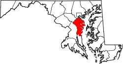
Arundel Gardens is an unincorporated community in Anne Arundel County, Maryland, United States. [2] Arundel Gardens is located along Maryland Route 2 north of Interstate 695, in the southern part of the Brooklyn Park census-designated place. [3]

