Asco, California

Last updated
Asco
Unincorporated community
California Locator Map with US.PNG
Red pog.svg
Asco
Location in California
Usa edcp location map.svg
Red pog.svg
Asco
Asco (the US)
Coordinates: 37°40′59″N121°52′22″W / 37.68306°N 121.87278°W / 37.68306; -121.87278 Coordinates: 37°40′59″N121°52′22″W / 37.68306°N 121.87278°W / 37.68306; -121.87278
Country United States
State California
County Alameda County
Elevation [1] 351 ft (107 m)

Asco is an unincorporated community in the Amador Valley, now part of Pleasanton in Alameda County, California.

Amador Valley is a valley in eastern Alameda County, California and is the location of the cities of Dublin and Pleasanton. The valley is bounded by the foothills of the Diablo Range on the north and south, Pleasanton Ridge to the west, and Livermore Valley to the east.

Pleasanton, California City in California, United States

Pleasanton is a city in Alameda County, California, incorporated in 1894. It is a suburb in the San Francisco Bay Area located about 25 miles (40 km) east of Oakland, and 6 miles (9.7 km) west of Livermore. The population was 70,285 at the 2010 census. In 2005 and 2007, Pleasanton was ranked the wealthiest middle-sized city in the United States by the Census Bureau. Pleasanton is home to the headquarters of Safeway, Workday, Ellie Mae, Roche Molecular Diagnostics, Blackhawk Network Holdings, and Veeva Systems. Other major employers include Kaiser Permanente, Oracle, Nordstrom and Macy's. Although Oakland is the Alameda County seat, a few county offices and a courthouse are located in Pleasanton. The Alameda County Fairgrounds are located in Pleasanton, where the county fair is held during the last week of June and the first week of July. Pleasanton Ridge Regional Park is located on the west side of town.

Alameda County, California County in California

Alameda County is a county in the state of California in the United States. As of the 2010 census, the population was 1,510,271, making it the 7th-most populous county in the state. The county seat is Oakland. Alameda County is included in the San Francisco Bay Area, occupying much of the East Bay region.

Contents

It is located on the former right of way of the Southern Pacific Railroad (now the Iron Horse Regional Trail) 6 miles (9.7 km) west of Livermore, [2] at an elevation of 351 feet (107 m).
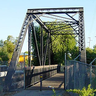
Iron Horse Regional Trail trail for pedestrians, horse riders and bicycles in California

The Iron Horse Regional Trail is a rail trail for pedestrians, horse riders and bicycles in the East Bay Area in California.

Livermore, California City in California, United States

Livermore is a city in Alameda County, California, in the United States. With an estimated 2017 population of 89,648, Livermore is the most populous city in the Tri-Valley. Livermore is located on the eastern edge of California's San Francisco Bay Area. The incumbent Mayor of Livermore is John Marchand.

History

The name comes from the Alameda Sugar Company (ASC), which later changed its name to Holly Sugar Company. The company raised crops there, including sugar beets, from 1899 until the mid-20th century. [2] [3]

California Beet Sugar Company former sugar beet factory, now historic site, in California

The California Beet Sugar Company was the first sugar beet factory in the United States. It was located in Union City, California and its site is on the California Historical Landmarks list.

Sugar beet Plant grown commercially for sugar production

A sugar beet is a plant whose root contains a high concentration of sucrose and which is grown commercially for sugar production. In plant breeding it is known as the Altissima cultivar group of the common beet. Together with other beet cultivars, such as beetroot and chard, it belongs to the subspecies Beta vulgaris subsp. vulgaris. Its closest wild relative is the sea beet.

Related Research Articles

Altamont, California Unincorporated community in California, United States

Altamont is an unincorporated community in Alameda County, California. It is located 7.5 miles (12 km) northeast of Livermore, at an elevation of 741 feet (226 m) in the Altamont Pass. It was in 1969 the site of the Altamont Free Concert at the Altamont Speedway. Originally called The Summit, the name was changed to Altamont when the Central Pacific Railroad arrived in 1869.

Canyon, California Unincorporated community in California, United States

Canyon, formerly known as Sequoya, is an unincorporated community located near the border of Contra Costa and Alameda counties, in the U.S. state of California. It is situated between Oakland and Moraga in the San Francisco Bay Area. The community is named for its location in the upper canyon of San Leandro Creek along the eastern slope of the Berkeley Hills. Canyon lies at an elevation of 1138 feet.

Asco, West Virginia Unincorporated community in West Virginia, United States

Asco is an unincorporated community located in McDowell County, West Virginia, United States. Asco was originally known as Atlantic. The current name derives from the American Smokeless Coal Company (ASCO). It lies at the end of a line of the Norfolk and Western Railroad in Davy Branch hollow.

Arroyo Mocho river in the United States of America

Arroyo Mocho is a 34.7-mile-long (55.8 km) stream which originates in the far northeastern corner of Santa Clara County and flows northwesterly into eastern Alameda County, California. After traversing the cities of Livermore and Pleasanton it joins South San Ramon Creek to become Arroyo de la Laguna, which in turn flows to Alameda Creek and thence to San Francisco Bay.

Kilkare Woods, California Unincorporated community in California, United States

Kilkare Woods, also known as Kilcare Woods, is a small rural unincorporated community of about 773 people in southern Alameda County, California, near Pleasanton.

Farwell, California Unincorporated community in California, United States

Farwell is an unincorporated community in Alameda County, California. It is located 3.5 miles (5.6 km) north-northeast of downtown Fremont, at an elevation of 223 feet (68 m). Its ZIP code is 94536 and its area code is 510.

Dresser, California Unincorporated community in California, United States

Dresser is an unincorporated community in Alameda County, California. Its ZIP code is 94536 and its area code is 510.

Sierra Azul Open Space Preserve

Sierra Azul Open Space Preserve is managed by the Midpeninsula Regional Open Space District in Santa Clara County, California. It's approximately 17,000 acres (6,900 ha) in area. The preserve is named for the Sierra Azul or "Blue Mountains", the name the colonizing Spanish used for the half of the Santa Cruz Mountains south of today's California Highway 17.

Land, California Former settlement in California, United States

Land is a former settlement in Butte County, California, United States. It was located 1.5 miles (2.4 km) west-southwest of Bidwell's Bar on the Western Pacific Railroad, at an elevation of 902 feet. Land is now covered by Lake Oroville. The place was named for A.H. Land, a lumber company president.

Albrae, California Unincorporated community in California, United States

Albrae is an unincorporated community in Alameda County, California. It is located on the Southern Pacific Railroad 4 miles (6.4 km) south-southwest of downtown Fremont, at an elevation of 10 feet.

Baumberg, California Unincorporated community in California, United States

Baumberg is an unincorporated community in Alameda County, California, adjacent to Hayward. It is located on the Southern Pacific Railroad 7 miles (11 km) north-northwest of downtown Newark, at an elevation of 16 feet (4.9 m).

Brightside, California Unincorporated community in California, United States

Brightside is an unincorporated community in Alameda County, California. It is located 2.25 miles (3.6 km) west of Sunol, at an elevation of 207 feet (63 m). At the turn of the 20th century a vacation/resort area and previously a gravel quarry, it is now the site of the train yard belonging to Niles Canyon Railway.

Brookshire, California Unincorporated community in California, United States

Brookshire is an unincorporated community in Alameda County, California. It lies at an elevation of 564 feet (172 m).

Dougherty, Alameda County, California Unincorporated community in California, United States

Dougherty is an unincorporated community in Alameda County, California. It is located just north of Dublin, at an elevation of 348 feet.

Greenville, Alameda County, California Former settlement in California, United States

Greenville is a former settlement in Alameda County, California. It was located 2.5 miles (4.0 km) southwest of Altamont, at an elevation of 584 feet. The name is in honor of John Green, first store owner here.

Midway, Alameda County, California Unincorporated community in California, United States

Midway is an unincorporated community in Alameda County, California, 6 miles (9.7 km) south-southeast of Altamont. It lies at an elevation of 358 feet. A post office operated in Midway from 1870 to 1918.

Radum, California Unincorporated community in California, United States

Radum is an unincorporated community in Alameda County, California. It lies at an elevation of 361 feet.

Alameda, Kern County, California Unincorporated community in California, United States

Alameda is an unincorporated community in Kern County, California. It is located 9 miles (14 km) south of Bakersfield, at an elevation of 331 feet (101 m).

Arroyo Valle river in the United States of America

Arroyo Valle or Arroyo Del Valle is a 36.4-mile-long (58.6 km) westward-flowing stream that begins in northeastern Santa Clara County, California, and flows northwesterly into Alameda County where it is dammed to form Lake Del Valle. After that Arroyo Valle is tributary to Arroyo de la Laguna which in turn flows into Alameda Creek and thence to San Francisco Bay. In previous times the Arroyo Valle had a significant steelhead migration; however, degradation of the stream in the latter half of the 20th century has decimated this anadromous fish population.

References

  1. "Asco". Geographic Names Information System . United States Geological Survey.
  2. 1 2 Durham, David L. (1998). California's Geographic Names: A Gazetteer of Historic and Modern Names of the State. Clovis, Calif.: Word Dancer Press. p. 597. ISBN   1-884995-14-4.
  3. Hartman, Louise. "It's Harvest Time". San Jose Mercury News. Retrieved 21 May 2014.
Geographic Names Information System geographical database

The Geographic Names Information System (GNIS) is a database that contains name and locative information about more than two million physical and cultural features located throughout the United States of America and its territories. It is a type of gazetteer. GNIS was developed by the United States Geological Survey in cooperation with the United States Board on Geographic Names (BGN) to promote the standardization of feature names.

United States Geological Survey scientific agency of the United States government

The United States Geological Survey is a scientific agency of the United States government. The scientists of the USGS study the landscape of the United States, its natural resources, and the natural hazards that threaten it. The organization has four major science disciplines, concerning biology, geography, geology, and hydrology. The USGS is a fact-finding research organization with no regulatory responsibility.