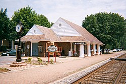
Clay County is a county in the east central part of the U.S. state of Alabama. As of the 2020 census the population was 14,236. Its county seat is Ashland. Its name is in honor of Henry Clay, famous American statesman, member of the United States Senate from Kentucky and United States Secretary of State in the 19th century. It was the last dry county in Alabama with no wet cities within its boundaries, until a vote on March 1, 2016, approved the sale of alcohol in Lineville and Ashland.

Huntington is a city in Cabell and Wayne counties in the U.S. state of West Virginia. The seat of Cabell County, the city is located at the confluence of the Ohio and Guyandotte rivers in the state's southwestern region. The population was 46,842 at the 2020 census, and was estimated to be 45,325 in 2023. Huntington is the second-most populous city in West Virginia. The Huntington–Ashland metropolitan area, spanning seven counties across West Virginia, Kentucky and Ohio, had an estimated population of 368,262 in 2023.

Boydton is a town in Mecklenburg County, Virginia, United States. The population was 302 at the 2020 census. It is the county seat of Mecklenburg County, and it is near Kerr Lake.

Courtland is an incorporated town in Southampton County, Virginia, United States. It is the county seat of Southampton County.

Waterford is a unique place of historic significance. The entire village and surrounding countryside is a National Historic Landmark District, noted for its well-preserved 18th and 19th-century character. It is an unincorporated village and census-designated place (CDP) in the Catoctin Valley of Loudoun County, Virginia, located along Catoctin Creek. Waterford is 47 miles (76 km) northwest of Washington, D.C., and 7 miles (11 km) northwest of Leesburg.

Green Springs National Historic Landmark District is a national historic district in Louisa County, Virginia noted for its concentration of fine rural manor houses and related buildings in an intact agricultural landscape. Admitted to the National Register of Historic Places in 1974, it became the first rural National Landmark Historic district. Named for one of the historic manor houses, the district comprises 14,000 acres (5,700 ha) of fertile land, contrasting with the more typical poor soil and scrub pinelands surrounding it.
Henry Wright, was a planner, architect, and major proponent of the garden city, an idea characterized by green belts and created by Sir Ebenezer Howard.

Burke's Garden is an upland valley and unincorporated community in Tazewell County, Virginia.

The Davis and Elkins Historic District is a National Historic Landmark District on the campus of Davis & Elkins College in Elkins, West Virginia. It includes two mansions, the Senator Stephen Benton Elkins House (Halliehurst) and Graceland, that are separately listed on the National Register of Historic Places. A gate house and an ice house are also included in the district. These four structures are associated with the families of Henry Gassaway Davis (1823-1916) and Stephen Benton Elkins (1841-1911), who were dominating figures in the politics and economy of West Virginia in the late 19th century. It was declared a National Historic Landmark in 1998.

The Alexandria Historic District is a National Historic Landmark District in Alexandria, Virginia. Encompassing all of the city's Old Town and some adjacent areas, this area contains one of the nation's best-preserved assemblages of the late-18th and early-19th century urban architecture. The district was locally designated in 1946 and was declared a National Historic Landmark in 1966.

Mountain View is a Roanoke, Virginia neighborhood located in central Roanoke north of the Roanoke River. It borders the neighborhoods of Norwich on the west, West End on the east, Hurt Park on the north and Raleigh Court and Wasena on the south.

The Harpers Ferry Historic District comprises about one hundred historic structures in Harpers Ferry, West Virginia. The historic district includes the portions of the central town not included in Harpers Ferry National Historical Park, including large numbers of early 19th-century houses built by the United States Government for the workers at the Harpers Ferry Armory. Significant buildings and sites include the site of the Armory, the U.S Armory Potomac Canal, the Harpers Ferry Train Station, and Shenandoah Street, Potomac Street, and High or Washington Street. The National Historic Park essentially comprises the lower, flood-prone areas of the town, while the Historic District comprises the upper town.

Case's Corner Historic District is a residential, civic, and rural historic district in the geographic center of Weston, Massachusetts. The district is centered on the four-way intersection of School, Wellesley, Newton and Ash Streets in Weston, Massachusetts, and runs mainly along Wellesley Street, which runs north-south through the district between the centers of Weston and Wellesley. The district encompasses a pastoral landscape managed by Marian Case, a horticulturalist and landscape preservationist. One of its central features is the Case Estates, a 60-acre (24 ha) property bequested by Case to Harvard University that once served as a nursery for Boston's Arnold Arboretum. The district was listed on the National Register of Historic Places in 2002.

The Central Square Historic District is a historic district encompassing much of the central business district of Stoneham, Massachusetts. It includes the town's largest concentration of 19th and early-20th century commercial architecture, in an area that developed in importance as a commercial center after the construction of the Andover-Medford Turnpike. The district was added to the National Register of Historic Places in 1990.

The Middleburg Historic District comprises the historic center of Middleburg, Virginia. The district extends along the downtown section of Washington Street, and is flanked on the east by Independence Street and to the west by Constitution Street. The district's commercial area is along Washington and Madison Streets. Middleburg was established in 1787, but the historic district includes a few 18th-century structures, with most dating to the mid-19th century. The district includes the Red Fox Inn & Tavern, the oldest building in town and listed individually on the National Register of Historic Places. Most of the structures in the core of the district are Federal style townhouses.

The Bluemont Historic District comprises the historic core of Bluemont, Virginia. The town is located on the eastern side of Snickers Gap, with the majority of the district fronting on the Snickersville Turnpike, also designated Virginia State Route 734. The district includes 43 buildings, of which 36 are houses, five are commercial structure, a church and a community center. The oldest structure in Bluemont is Clayton Hall (1797), a large stone house. The Amos Clayton farm was located at the junction of Routes 734 and 760, now in the center of town. Relatively few pre-Civil War structures remain in Bluemont. Apart from Clayton Hall, the most significant is the Bluemont Methodist Church.

Farmington is a house near Charlottesville, in Albemarle County, Virginia, that was greatly expanded by a design by Thomas Jefferson that Jefferson executed while he was President of the United States. The original house was built in the mid-18th century for Francis Jerdone on a 1,753-acre (709 ha) property. Jerdone sold the land and house to George Divers, a friend of Jefferson, in 1785. In 1802, Divers asked Jefferson to design an expansion of the house. The house, since greatly enlarged, is now a clubhouse.
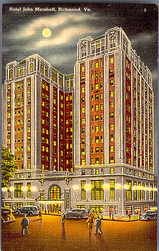
The Grace Street Commercial Historic District is a national historic district located in Richmond, Virginia. The district encompasses 93 contributing buildings located in downtown Richmond. The buildings reflect the core of the city's early 20th-century retail development and the remnants of a 19th-century residential neighborhood. The buildings are in a variety of popular 19th-century and early 20th-century architectural styles, including Classical Revival, Mission Revival, International Style, and Colonial Revival. Notable buildings include the Administration and Equipment Building for the Chesapeake & Potomac Telephone Company (1929), Thalhimer's Department Store, Atlantic Life Building (1950-1959), Miller & Rhoads Department Store, Berry-Burk Building, former W. W. Foster Studios (1927), Bank of Virginia (1949), Investment Realty Company building (1930), W.T. Grant Store (1939), Hotel John Marshall (1927), Franklin Federal Savings and Loan building (1954), and the Tompkins House (1820). Located in the district and separately listed are the Loew's Theatre, Centenary United Methodist Church, Joseph P. Winston House, Central National Bank, and National Theater.

The Portsmouth Downtown Historic District encompasses the historic urban core of Portsmouth, New Hampshire. With a history dating to the 17th century, Portsmouth was New Hampshire's principal seaport and the center of its economy for many decades, and the architecture of its urban center is reflective of nearly four centuries of history. The district is roughly L-shaped, radiating from the downtown Market Square area to South Street in the south and Madison and Columbia streets in the west, with more than 1,200 historically significant buildings. It was listed on the National Register of Historic Places in 2017. The district includes 35 previous listings on the National Register, and five National Historic Landmarks.

The West Main Street Historic District encompasses a late 19th and early 20th century commercial area of Charlottesville, Virginia, developed during the area's growth as a streetcar suburb. It is basically linear in character, extending along West Main Street from Ridge Street in the east to the railroad crossing west of 8th Street in the west. The oldest building in the district is the c. 1820 Inge's Store, and the district includes the city's memorial to Meriwether Lewis and William Clark.