
Malappuram, is one of the 14 districts in the Indian state of Kerala, with a coastline of 70 km (43 mi). It is the most populous district of Kerala, which is home to around 13% of the total population of the state. The district was formed on 16 June 1969, spanning an area of about 3,554 km2 (1,372 sq mi). It is the third-largest district of Kerala by area, as well as the largest district in the state, bounded by Western Ghats and Arabian Sea to either side. The district is divided into seven Taluks: Eranad, Kondotty, Nilambur, Perinthalmanna, Ponnani, Tirur, and Tirurangadi.

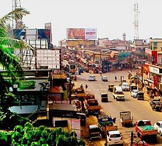
Kottakkal is a municipal town in Malappuram district in Kerala, southern India having 32 wards. it is a part of Malappuram metropolitan area and a growing city in Kerala. The town is best known for the Arya Vaidya Sala, one of the top Ayurvedic health centres of the world. Kottakkal is also a major growing commercial, educational, and healthcare hub in South Malabar. The town lies on Mumbai–Kanyakumari National Highway 66.
Azhvanchery Thamprakkal or Azhvanchery Samrāṭ is the title of the senior-most male member of the Nambudiri Brahmin feudal lords of Azhvanchery Mana in Athavanad, Kerala, South India. They had the right over Guruvayur, and were the titular head of all Nambudiri Brahmins of Kerala. The Lord of Azhvanchery based at Athavanad and the Lord of Kalpakanchery based at neighbouring Kalpakanchery were usually present at the coronation of a new Zamorin of Kozhikode. Kalpakanchery Thamprakkals were related to the Nambudiris of Panniyoor while Azhvanchery Thamprakkals to those of Chowwara.

Tirur is a major town municipality in Malappuram district in the Indian state of Kerala spread over an area of 16.55 square kilometres (6.39 sq mi). It is one of the business centers of Malappuram district and is situated 26 kilometres (16 mi) west of Malappuram and 52.5 kilometres (32.6 mi) south of Kozhikode, on the Shoranur–Mangalore section under Southern Railway. Tirur is also a major regional trading centre for fish and betel leaf and has an average elevation of 2 metres.

Kuttippuram is a town and a block headquarters, which is situated in the Tirur Taluk, Malappuram district of Kerala state, India. The town is located 34 kilometres south-west of Palakkad. The Bharathappuzha river flows through Kuttippuram. According to the last Census of India conducted in 2011,

Valanchery is a major municipal town in Malappuram district, Kerala, India. It is one of the four municipalities in Tirur Taluk, besides Tirur, Kottakkal, and Tanur. It is situated about 40 kilometres (25 mi) southeast to Karipur International Airport and 25 kilometres (16 mi) southwards to the district headquarters, and forms a part of Malappuram metropolitan area. It is also one of the major commercial towns under the Malappuram urban agglomeration. Valanchery, which was a part of the erstwhile princely state of the Valluvanad in the early medieval period, had been under the direct control of the Zamorin of Calicut following the Tirunavaya war of 14th century CE. During British Raj, Valanchery was included in the Ponnani Taluk of erstwhile Malabar District. Vattapara accident zone is an accident zone near Valanchery. Valanchery is situated on National Highway 66.

Kadampuzha is a small town and a pilgrimage centre in Malappuram district of Kerala situated near the Thrissur-Calicut national highway.
Athavanad is a village and Gram Panchayath in the Tirur Taluk, in the Malappuram District of the state of Kerala, India. The town lies on the National Highway 17, between Puthanathani and Valanchery. Puthanathani is the main town of the Athavanad village and the village office is located in Athavanad Para & Kurumbathoor. Nearby towns include Valanchery, Tavanur, Tirunavaya, Kuttippuram, Irimbiliyam, and Edayur. Athavanad is also famous for historical Azhvanchery Mana which built about 400 years ago.
Kalpakanchery is a revenue village and a Gram Panchayat in Tirur Taluk, Malappuram district, Kerala, India. The village is located 21 kilometres (13 mi) south-west to the city of Malappuram.
Marakkara is a grama panchayath in Kuttippuram Block Panchayat, Tirur Taluk, Malappuram district in the state of Kerala, India.

Nediyiruppu was the capital of the Zamorin's kingdom in colonial Kerala. At the time, it was known as Nediyiruppu Swaroopam. It is a region of the Kondotty municipality in Malappuram district, Kerala, India. It is situated 24 kilometres (15 mi) from Malappuram, the district headquarters.

Parappur is a village and townland two kilometers north of Kottakkal in Malappuram district in the state of Kerala, India.

Purathur is a beautiful sandy coastal village and a Grama Panchayat in Tirur Taluk, Malappuram district in the state of Kerala, India. Bharathappuzha river and Tirur River merges together in Purathur and join with the Arabian Sea at Padinjarekara Azhimukham, which is also the southernmost tip of Purathur Gram panchayat. Opposite to Padinjarekara Azhimukham is Ponnani port. The village is located at the southernmost tip of Tirur Taluk and is bordered by historically important Ponnani port in Ponnani Municipality of Ponnani taluk to south.
Puthuparamba or puthuparambu is a natural village in Edarikode Grama Panchayath which located near to NH 66 Pookipparamba Malappuram District of Kerala, India. Postal code is 676501

Tirur Taluk comes under Tirur revenue division in Malappuram district of Kerala, India. Its headquarters is the town of Tirur. Tirur Taluk contains four municipalities - Tanur, Tirur, Kottakkal, and Valanchery. Most of the administrative offices are located in the Mini-Civil Stations at Tirur, Kuttippuram, and Tanur. Most of the villages in present-day Tirur Taluk were parts of the medieval Kingdom of Tanur (Vettathunadu). The port of Tanur was an important port town in the southwestern coast of India during medieval period.
Puthanathani is a census town in Malappuram district in the state of Kerala, India. The town lies on the National Highway 66 (India), between Kottakkal and Valanchery. Roads to Vailathur and Thirunavaya also can be seen in Puthanathani.

Malappuram district is an education hub of the state of Kerala, India with four universities, two medical colleges, two law colleges and several engineering and arts colleges. The city has several educational institutions from the school level to higher education. Kendriya Vidyalaya, Jawahar Navodaya Vidyalaya, Malabar Special Police HSS, Government Girls Higher secondary school, Govt. Boys, St.Gemmas HSS, Islahiya HSS, A.U.P School, Sree Arunodaya Vidya Nigethan etc. to name a few schools. The city is lacking an Engineering College under Government despite having the largest number of students appearing and excelling in respective entrance exams. Govt. College, Malappuram, which is the oldest college in the city, started in 1972, College of Applied Science Malappuram and Govt. College for Women started this year along with many other private colleges serves the higher educational purpose. Govt.TTI and MCT TTI are few teachers training institutes. The Regional Directorate of Higher Secondary Education and Regional Office (Malabar) of State Open School are located in the city inside the Civil Station.
Valiyakunnu is a town located in Malappuram district, Kerala, India.

South Malabar refers to a geographical area of the southwestern coast of India covering some parts of the present-day Kerala. South Malabar covers the regions included in present-day Kozhikode taluk of Kozhikode district, the whole area of Malappuram district, Chavakkad taluk of Thrissur district, and Palakkad district, excluding parts of Chittur taluk. The Fort Kochi region of Kochi city also historically belongs to South Malabar. The term South Malabar refers to the region of the erstwhile Malabar District south to the river Korapuzha, and bears a high cultural similarity to both the Cochin and the North Malabar region.

The Kuttippuram Block Panchayat is the block-level administrative body that administers the region around Kuttippuram in Malappuram district, Kerala, India. It is also one of the 15 Block Panchayats established for the proper block-level administration of Gram panchayats in the district. Established in 1962, the block's current president is Vaseema Veleri since 2020. Kuttippuram Block Panchayat lies in two assembly constituencies – Kottakkal and Tirur – both of which are part of the Ponnani parliamentary constituency. The Block is headed by a President and council, and manages 155.83 km2 of Kuttippuram block, with a population of about 229,468 within that area.


