Athens, New York

Last updated

Athens, New York
Athens Lower Village Historic District-Public Library May 11.jpg
Athens Public Library
Greene County NY Athens town highlighted.svg
Location in Greene County and the state of New York.
New York in United States (US48).svg
Location of New York in the United States
Coordinates: 42°16′07″N73°48′20″W / 42.26861°N 73.80556°W / 42.26861; -73.80556
CountryUnited States
State New York
County Greene
Government
  Village MayorStephan Bradicich
  • Robert F. Butler, Jr. (R)
  • Eugene J. Hatton (R)
  • April Paluch (R)
  • Phyllis Dinkelacker (D)
   Town Supervisor Robert F. Butler, Jr.
Area
[1]
  Total28.87 sq mi (74.77 km2)
  Land26.25 sq mi (67.98 km2)
  Water2.62 sq mi (6.79 km2)
Population
 (2020)
  Total3,916
  Density140/sq mi (52/km2)
Time zone UTC-5 (EST)
  Summer (DST) UTC-4 (EDT)
ZIP code
12015
Area code 518
FIPS code 36-039-02913

Athens is a town in Greene County, New York, United States. The population was 3,916 at the 2020 census. [2] The town of Athens has a village also called Athens. The town is near the eastern edge of the county.

Contents

History

The town of Athens was formed on February 25, 1815 [3] from parts of the towns of Catskill and Coxsackie.

In 1890, the total population was 2,361.

Geography and climate

According to the United States Census Bureau, the town has a total area of 28.8 square miles (74.7 km2), of which 26.2 square miles (67.8 km2) is land and 2.7 square miles (6.9 km2, or 9.22%) is water.

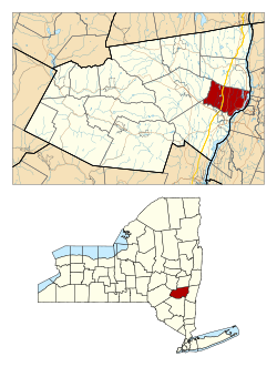
The eastern town line is defined by the . ATHENS River and is the border of Columbia County.

U.S. Route 9W and the New York State Thruway (Interstate 87) pass through the town.

Climate data for Athens, New York
MonthJanFebMarAprMayJunJulAugSepOctNovDecYear
Record high °F (°C)66
(19)
72
(22)
85
(29)
94
(34)
95
(35)
97
(36)
103
(39)
97
(36)
96
(36)
90
(32)
82
(28)
71
(22)
103
(39)
Mean daily maximum °F (°C)34
(1)
37
(3)
47
(8)
61
(16)
72
(22)
80
(27)
85
(29)
82
(28)
74
(23)
63
(17)
50
(10)
38
(3)
60
(16)
Mean daily minimum °F (°C)16
(−9)
19
(−7)
28
(−2)
38
(3)
49
(9)
58
(14)
63
(17)
61
(16)
54
(12)
42
(6)
33
(1)
23
(−5)
40
(4)
Record low °F (°C)−26
(−32)
−18
(−28)
−8
(−22)
12
(−11)
24
(−4)
34
(1)
40
(4)
37
(3)
27
(−3)
18
(−8)
5
(−15)
−15
(−26)
−26
(−32)
Average precipitation inches (mm)3.11
(79)
2.46
(62)
3.30
(84)
3.56
(90)
4.29
(109)
3.82
(97)
3.92
(100)
3.81
(97)
3.83
(97)
3.47
(88)
3.36
(85)
3.10
(79)
42.03
(1,068)
Average snowfall inches (cm)8.7
(22)
7.0
(18)
3.9
(9.9)
1.2
(3.0)
0
(0)
0
(0)
0
(0)
0
(0)
0
(0)
0
(0)
0.8
(2.0)
6.7
(17)
28.3
(72)
Source: PlantMaps [4]

Demographics

Historical population
CensusPop.Note
1820 2,030
1830 2,42519.5%
1840 2,387−1.6%
1850 2,98625.1%
1860 2,791−6.5%
1870 2,9425.4%
1880 3,0654.2%
1890 2,876−6.2%
1900 2,8910.5%
1910 2,720−5.9%
1920 2,361−13.2%
1930 2,254−4.5%
1940 2,3755.4%
1950 2,372−0.1%
1960 2,80418.2%
1970 3,56727.2%
1980 3,462−2.9%
1990 3,5612.9%
2000 3,98812.0%
2010 4,0892.5%
2020 3,916−4.2%
U.S. Decennial Census [5] >

As of the census [6] of 2000, there were 3,991 people, 1,600 households, and 1,110 families residing in the town. The population density was 152.5 inhabitants per square mile (58.9/km2). There were 1,972 housing units, with an average density of 75.3 per square mile (29.1/km2). The racial makeup of the town was 95.87% White, 0.98% Black or African American, 0.28% Native American, 0.85% Asian, 0.05% Pacific Islander, 0.65% from other races, and 1.33% from two or more races. Hispanic or Latino of any race were 1.70% of the population.

There were 1,600 households, out of which 29.4% had children under the age of 18 living with them, 54.8% were married couples living together, 9.7% had a female householder with no husband present, and 30.6% were non-families. 25.3% of all households were made up of individuals, and 13.4% had someone living alone who was 65 years of age or older. The average household size was 2.48 and the average family size was 2.96.

In the town, the population was spread out, with 23.3% under the age of 18, 5.9% from 18 to 24, 27.8% from 25 to 44, 27.2% from 45 to 64, and 15.9% who were 65 years of age or older. The median age was 41 years. For every 100 females, there were 94.2 males. For every 100 females age 18 and over, there were 92.0 males.

The median income for a household in the town was $39,719, and the median income for a family was $43,672. Males had a median income of $33,913 versus $22,316 for females. The per capita income for the town was $20,910. About 7.0% of families and 8.7% of the population were below the poverty line, including 11.4% of those under age 18 and 8.6% of those age 65 or over.

Communities and locations in the Town of Athens

Electric power facilities

New Athens Generating

Pursuant to Article X of the Public Service Law, Athens Generating Company, L.P. (now operating as New Athens Generating Company, LLC) was granted a Certificate of Environmental Compatibility and Public Need for a 1,080-megawatt (MW) combined cycle natural gas powered plant in 2000. It went into service in 2004. There are three combustion turbines whose exhaust creates steam to drive a steam turbine. All of the combustion turbines are manufactured by Siemens. It uses a wet/dry (hybrid) cooling system consisting of three groups of six hybrid cooling units. It is located on a 150-acre area that was zoned as light industrial, to the west of the Village of Athens. In 2017, it injected 3,891 GWh of electric energy into the electric transmission system. This is equivalent to operating at full capacity for approximately 40.4% of the year. For comparison, the capital region consumed 11,823 GWh of electric energy in 2017. [7] [8] [9]

The plant has reorganized and transferred ownership several times since it was granted a certificate in 2000. As of 2018 it is owned by New Athens Generating Company, LLC, which is owned by New Mach Gen, LLC, which is owned by Mach Gen, LLC, which is owned by Talen Energy Supply, LLC, which is owned by Riverstone Holdings LLC. It was noted in a recent declaratory ruling that Con Edison has a bilateral agreement with New Athens Generating Company whereby Con Edison buys the plant's output and sells it in the NYISO wholesale market. [10] In its 2017-2018 adopted budget, the Village of Athens noted a revenue of about $9,000 from payments in lieu of taxes most of which can be assumed to come from New Athens Generating Company, LLC. For comparison, the Village of Athens noted a total budget of about $2.15 million for 2017-2018. [11]

West Point Partners

A High Voltage Direct Current underground transmission line was proposed in an Article VII filing with the Public Service Commission in 2013. Its northern converter station would have been located adjacent to the New Athens Generating facility. The certification process was placed in limbo after the real estate for its planned southern converter station near the Indian Point Energy Center was sold in private auction from Con Edison to the Town of Cortlandt. [12] [13]

A major plot point in War of the Worlds (2005) took place in Athens. In the movie, most of the town is shown being destroyed. These are the scenes where the flaming train passes by the cast and the crowd is going towards the ferry.

Related Research Articles

<span class="mw-page-title-main">Colebrook, Connecticut</span> Town in Connecticut, United States

Colebrook is a town in Litchfield County, Connecticut, United States. The population was 1,361 at the 2020 census. The town is part of the Northwest Hills Planning Region. Colebrook was named after Colebrooke in the English county of Devon; the reason is now unknown.

<span class="mw-page-title-main">Indian Village, Indiana</span> Town in Indiana, United States

Indian Village is a town in Clay Township, St. Joseph County, in the U.S. state of Indiana. The population was 133 at the 2010 Census. It is part of the South Bend–Mishawaka, IN-MI, Metropolitan Statistical Area.

<span class="mw-page-title-main">Lempster, New Hampshire</span> Place in New Hampshire, United States

Lempster is a town in Sullivan County, New Hampshire, United States. The population was 1,118 at the 2020 census. Settlements include the town center and the village of East Lempster.

<span class="mw-page-title-main">Bethlehem, New York</span> Town in New York, United States

Bethlehem is a town in Albany County, New York, United States. The town's population was 35,034 at the 2020 census. Bethlehem is located immediately to the south of the city of Albany and includes the following hamlets: Delmar, Elsmere, Glenmont, North Bethlehem, Selkirk, Slingerlands, and South Bethlehem. U.S. Route 9W passes through the town. The town is named after the biblical Bethlehem.

<span class="mw-page-title-main">Dover, New York</span> Town in New York, United States

Dover is a town in Dutchess County, New York, United States. The population was 8,415 at the 2020 census. The town was named after Dover in England, the home town of an early settler.

<span class="mw-page-title-main">Fenner, New York</span> Town in New York, United States

Fenner is a town in Madison County, New York, United States. The population was 1,726 at the 2010 census.

<span class="mw-page-title-main">Rensselaer, New York</span> City in Rensselaer County, New York, US

Rensselaer is a city in Rensselaer County, New York, United States, and is located on the east side of the Hudson River, opposite Albany and on the western border of Rensselaer County. As of the 2020 census, the city population was 9,210.

<span class="mw-page-title-main">Stephentown, New York</span> Town in New York, United States

Stephentown is a town in Rensselaer County, New York, United States. The population was 2,791 at the 2020 census. The town, which was originally Jericho Hallow in the Massachusetts Bay Colony, was renamed for Stephen Van Rensselaer. The town is located in the southeastern corner of the county, and has a sign proclaiming it to be the only Stephentown on Earth.

<span class="mw-page-title-main">Coolville, Ohio</span> Village in Ohio, United States

Coolville is a village located in Troy Township, Athens County, Ohio, United States, in the southeast area of the state. The population was 452 at the 2020 census.

<span class="mw-page-title-main">Glouster, Ohio</span> Village in Ohio, United States

Glouster is a village in Trimble Township, Athens County, Ohio, United States. The population was 1,659 at the 2020 census. It is close to Burr Oak State Park.

<span class="mw-page-title-main">Stratton, Ohio</span> Village in Ohio, United States

Stratton is a village in northern Jefferson County, Ohio, United States, along the Ohio River. The population was 267 at the 2020 census. It is part of the Weirton–Steubenville metropolitan area.

<span class="mw-page-title-main">Philo, Ohio</span> Village in Ohio, United States

Philo is a village in Muskingum County, Ohio, United States, along the Muskingum River. The population was 720 at the 2020 census. It is part of the Zanesville micropolitan area. Philo is the closest municipality to Blue Rock State Park.

<span class="mw-page-title-main">Narragansett, Rhode Island</span> Town in Rhode Island, United States

Narragansett is a town in Washington County, Rhode Island, United States. The population was 14,532 at the 2020 census. However, during the summer months the town's population more than doubles to near 34,000. The town of Narragansett occupies a narrow strip of land running along the eastern bank of the Pettaquamscutt River to the shore of Narragansett Bay. It was separated from South Kingstown in 1888 and incorporated as a town in 1901.

<span class="mw-page-title-main">New Johnsonville, Tennessee</span> City in Tennessee, United States

New Johnsonville is a city in Humphreys County, Tennessee, United States. The population was 1,951 at the 2010 census.

<span class="mw-page-title-main">Grant Town, West Virginia</span> Town in West Virginia, United States

Grant Town is a town in Marion County, West Virginia, in the eastern United States. The population was 690 at the 2020 census.

<span class="mw-page-title-main">Green Island, New York</span> Town and village in New York, United States

Green Island is a coterminous town-village in Albany County, New York, United States, some 8 miles (13 km) north of Albany. Green Island is one of only five such town-village amalgamations in New York. The population was 2,934 at the 2020 census, and the ZIP code is 12183. While the town of Green Island was once an island, it was connected to the mainland on the west side of the Hudson River in the 1960s.

<span class="mw-page-title-main">Greene (village), New York</span> Village in New York, United States

Greene is a village in Chenango County, New York, United States. The population was 1,580 at the 2010 census. The village is named after General Nathanael Greene. It is within the town of Greene and is northeast of Binghamton.

<span class="mw-page-title-main">Greene, New York</span> Town in New York, United States

Greene is a town in Chenango County, New York, United States. The population was 5,604 at the 2010 census. The town is named after General Nathanael Greene. It is located in the southwestern corner of the county and contains a village, also named Greene. The town and village are northeast of Binghamton. Greene was founded in 1792, but commenced in 1798.

<span class="mw-page-title-main">Catskill (village), New York</span> Village in New York, United States

Catskill is a village and county seat of Greene County, New York, United States. The population was 3,745 at the 2020 census, down from 4,081 at the 2010 census, down from 4,392 in 2000. The village is in the northeastern part of the town of Catskill.

<span class="mw-page-title-main">Castile, New York</span> Town in New York, United States

Castile is an incorporated town in Wyoming County, New York. The population was 2,873 at the 2000 census. The town is named after the historical region of Castile in Spain. The Town of Castile is on the east border of the county. The town contains a village which is also named Castile.

References

  1. "2016 U.S. Gazetteer Files". United States Census Bureau. Retrieved July 5, 2017.
  2. U.S. Census, 2020, 'Athens town, Greene County, New York'
  3. "History of Athens, NY". www.townofathensny.com. Town of Athens, NY. Retrieved February 2, 2022.
  4. "Zipcode 12015 - Athens, New York Hardiness Zones". PlantMaps. Retrieved August 8, 2021.
  5. U.S. Census, 2020, 'Athens town, Greene County, New York'
  6. "U.S. Census website". United States Census Bureau . Retrieved January 31, 2008.
  7. "OPINION AND ORDER GRANTING CERTIFICATE OF ENVIRONMENTAL COMPATIBILITY AND PUBLIC NEED (case no. 97-F-1563)". NYSPSC. June 15, 2000. pp. 5–7, 126–127. Retrieved November 18, 2018.
  8. "NYISO 2018 Gold Book (pdf)". www.nyiso.com. pp. 13, 57. Retrieved November 26, 2018.
  9. "NAES Athens Generating Plant Webpage" . Retrieved November 18, 2018.
  10. "DECLARATORY RULING ON A TRANSFER TRANSACTION (case no. 16-E-0401)". NYSPSC. September 19, 2016. pp. 1–4. Retrieved November 18, 2018.
  11. "Village of Athens Budget Webpage" (PDF). p. 5,16. Retrieved November 18, 2018.
  12. NYSPSC case no. 13-T-0292
  13. "WPP requests suspension of schedule". October 29, 2014. Retrieved November 18, 2018.