
The North Loop is a neighborhood in the Central community of Minneapolis.

Hillcrest Historic District is an historic neighborhood in Little Rock, Arkansas that was listed on the National Register of Historic Places on December 18, 1990. It is often referred to as Hillcrest by the people who live there, although the district's boundaries actually encompass several neighborhood additions that were once part of the incorporated town of Pulaski Heights. The town of Pulaski Heights was annexed to the city of Little Rock in 1916. The Hillcrest Residents Association uses the tagline "Heart of Little Rock" because the area is located almost directly in the center of the city and was the first street car suburb in Little Rock and among the first of neighborhoods in Arkansas.

Capitol View/Stifft's Station is a neighborhood of Little Rock, Arkansas, in the west-central portion of the city encompassing approximately 1500 homes. Roughly, its boundaries include the area south of West Markham, north of Interstate 630, east of Pine, and west of Summit, as well as south of Riverview between Park and Summit. Capitol View/Stifft's Station is just west of Downtown, north of the Central High School Historic District, southeast of Pulaski Heights and uses the 72205 ZIP code.

U.S. Route 64 is a U.S. highway running from Teec Nos Pos, Arizona east to Nags Head, North Carolina. In the U.S. state of Arkansas, the route runs 246.35 miles (396.46 km) from the Oklahoma border in Fort Smith east to the Tennessee border in Memphis. The route passes through several cities and towns, including Fort Smith, Clarksville, Russellville, Conway, Searcy, and West Memphis. US 64 runs parallel to Interstate 40 until Conway, when I-40 takes a more southerly route.

White River Junction Historic District is a historic district in the unincorporated village of White River Junction, within the town of Hartford, Vermont. It was first listed on the National Register of Historic Places in 1980, and its boundaries were increased in 2002 and 2019. It originally encompassed the central portion of the village's business district, and was then expanded to include a broader array of resources.

The Wilson Park Historic District is a historic district in Fayetteville, Arkansas, USA, located just northeast of the University of Arkansas. The district consists of several residential buildings that developed during the late 19th and early 20th Century near Wilson Park just north of Dickson Street, the city's primary entertainment district. Wilson Park Historic District includes 47 contributing buildings.
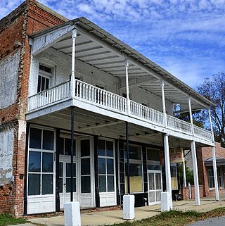
The Arkansas City Commercial District encompasses the three oldest surviving commercial buildings in Arkansas City, Arkansas. They are located along Sprague (4th) Avenue, between Kate Adams (1st) Street and De Soto Avenue, and are a reminder of a once-thriving commercial district in the city. The Cotham Drug Store, a two-story brick building from c. 1900, stands near the corner of Sprague and De Soto, facing south. The Red Star Grocery, built 1900, stands to its right; it is also a two-story brick building, but its facade has been altered, replacing a recessed doorway with a flush one. Stylistically the two buildings are similar, with brick corbelling and a course of dentil molding, with a parapet above. The third building is the Ramus Brothers Market, which stands on Sprague Street, and was built in 1910 out of poured concrete.
The Lake Village Commercial Historic District encompasses the historic commercial heart of Lake Village, Arkansas, the county seat of Chicot County in the Mississippi River delta region of southeastern Arkansas. The district covers about six square blocks of downtown Lake Village, bounded roughly by Jackson Street to the north, Lakeshore Drive to the east, Church Street to the south, and Chicot Street to the west. This area represents the growth of Lake Village during its period of greatest prosperity, between 1906 and 1960. The city's growth was spurred by the arrival of the railroad in 1903, and most of the district's buildings were built between 1900 and 1930. Most of the buildings are vernacular commercial buildings; the John Tushek Building at 202 Main Street is one interesting example of Beaux Arts styling, and 218–222 Main Street has some Italianate styling. The district includes the Lake Village Confederate Monument, which has been a local landmark since 1910.
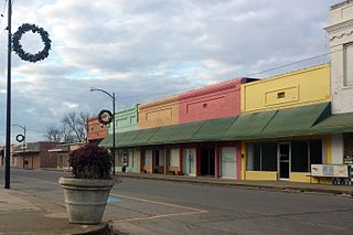
The Star City Commercial Historic District encompasses the historic commercial center of Star City, Arkansas, the county seat of Lincoln County. The district consists of thirteen buildings on two city blocks, as well as the Star City Confederate Memorial. The buildings are located on Jefferson Street, between Arkansas and Bradley Streets, and on Bradley Street between Jefferson and Drew Streets. The memorial is located in the town square, near the junction of Jefferson and Bradley. The buildings in the district were built between 1916 and 1928, and have for the most part escaped major alterations since their construction. Minor changes generally involve changes to store fronts, such as the boarding over of transom windows, the replacement of recessed entries with flush ones, and changes to the fenestration. The building at 108 Jefferson, built in 1927 to house a bar, has been extensively remodeled and does not contribute to the district's significance; the Star Theater building at 212-214 Bradley has also been extensively altered.

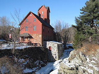
The Newmarket Industrial and Commercial Historic District encompasses the heart of a distinctive 19th century mill town, Newmarket, New Hampshire. Its mill complex is regionally distinctive for its extensive use of stone from an early date, and the town is relatively well-preserved due to a significant economic decline after the mills closed in 1920. The district was listed on the National Register of Historic Places in 1980. The Stone School, listed in 1978, is a contributing resource.

The Arkadelphia Commercial Historic District encompasses the historic commercial core of Arkadelphia, Arkansas, the county seat of Clark County. Arkadelphia was settled in 1842, and its commercial district is located in one of the older parts of the city, near the Ouachita River. Most of the buildings were built between c. 1890 and c. 1920, and are built out of brick and masonry; the oldest building in the district is estimated to have been built in 1870.

The Mena Commercial Historic District encompasses the historic downtown area of Mena, Arkansas, the county seat of Polk County in western Arkansas. The district extends along Mena Street between Port Arthur and Gillham Avenues, extending a short way to the south on Sherwood Avenue, opposite the railroad tracks for which the town's existence is responsible. Mena was founded as a major railroad service town for the Kansas City, Pittsburg and Gulf Railroad, as its site was located midway between Port Arthur, Texas and Kansas City, Missouri. The railroad located a major service yard here, and the town grew up around it. Most of its commercial center was developed between 1896 and 1940, with a variety of one and two-story commercial brick buildings in typical early 20th-century styles. The district, listed on the National Register of Historic Places in 2009, includes four properties previously listed separately: the railroad station, Mena City Hall, the former Elks Lodge, and the former Studebaker Showroom.

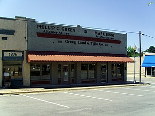
The Pine Bluff Commercial Historic District encompasses a portion of the historic city center of Pine Bluff, Arkansas. It extends from Barraque Street south along Main Street, extending in places to properties alongside streets. The area's commercial development began about 1840, when the courthouse square was laid out at Barraque and Main, and proceeded through the early 20th century. Most of the commercial properties of the district were built between 1880 and 1910, and are reflective architecturally of late 19th-century commercial building styles.

The South Main Street Residential Historic District encompasses a residential area south of downtown Little Rock, Arkansas. The area, extending along South Main Street roughly between 19th and 23rd Streets, was developed between about 1880 and 1945, and includes a well-preserved set of residential architecture from that period. Notable buildings include the Luxor Apartments, the Holcomb Court Apartments, and the Ada Thompson Memorial Home.

The Paris Commercial Historic District encompasses much of the commercial heart of downtown Paris, Arkansas. Centered on the courthouse square, where the Logan County Courthouse, Eastern District is located, the district contains a well-preserved collection of mainly commercial architecture from the turn of the 20th century. The district includes the buildings facing the courthouse square, as well as additional buildings extending down South Express and South Elm Streets, and the cross streets between them.

The Bethel Village Historic District encompasses the historic core of the village of Bethel in the town of Bethel, Vermont, USA. The L-shaped district extends along Main and Church Streets, including many of the village's commercial and civic buildings, as well as a significant number of 19th and early 20th-century residences. The district was listed on the National Register of Historic Places in 1976, and was slightly enlarged in 1990.

The Waterville Main Street Historic District encompasses the best-preserved portions of the historical commercial downtown area of Waterville, Maine. Developed most intensively in the late 19th and early 20th centuries, this area was the center of commerce for Waterville and the surrounding rural communities. It encompasses 25 properties on Main and Common Streets, including the Waterville Opera House and City Hall. It was listed on the National Register of Historic Places in 2012, and was slightly enlarged in 2016.
The Jericho Village Historic District encompasses the historic industrial and commercial center of the village of Jericho, Vermont. Stretched along Vermont Route 15 south of Browns River, which powered the village's industries for many years, the village center includes a well-preserved array of 19th and early 20th-century buildings. The district was listed on the National Register of Historic Places in 1992.

The St. Johnsbury Historic District encompasses much of the historic civic and commercial center of St. Johnsbury, Vermont. Representing a significant expansion of the Railroad Street Historic District and the St. Johnsbury Main Street Historic District, it captures the historical tension and competition between Main Street and Railroad Street for primacy as the town's most important civic and commercial areas. The district was listed on the National Register of Historic Places in 1980.

The Portsmouth Downtown Historic District encompasses the historic urban core of Portsmouth, New Hampshire. With a history dating to the 17th century, Portsmouth was New Hampshire's principal seaport and the center of its economy for many decades, and the architecture of its urban center is reflective of nearly four centuries of history. The district is roughly L-shaped, radiating from the downtown Market Square area to South Street in the south and Madison and Columbia streets in the west, with more than 1,200 historically significant buildings. It was listed on the National Register of Historic Places in 2017. The district includes 35 previous listings on the National Register, and five National Historic Landmarks.


