Avdellero | |
|---|---|
village | |
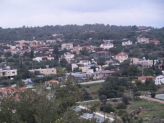
 Avdellero Location in Cyprus | |
| Coordinates: 35°0′35″N33°34′11″E / 35.00972°N 33.56972°E Coordinates: 35°0′35″N33°34′11″E / 35.00972°N 33.56972°E | |
| Country | |
| District | Larnaca District |
| Population (2011) [1] | |
| • Total | 218 |
| Time zone | UTC+2 (EET) |
| • Summer (DST) | UTC+3 (EEST) |
Avdellero (Greek : Αβδελλερό [locally [aftelːeˈɾo] ]) is a village in the Larnaca District of Cyprus, located 8 km south of Athienou. It has a ridge situated to the North of it which can be flown by Paraglider and Hang glider.

Greek is an independent branch of the Indo-European family of languages, native to Greece, Cyprus and other parts of the Eastern Mediterranean and the Black Sea. It has the longest documented history of any living Indo-European language, spanning more than 3000 years of written records. Its writing system has been the Greek alphabet for the major part of its history; other systems, such as Linear B and the Cypriot syllabary, were used previously. The alphabet arose from the Phoenician script and was in turn the basis of the Latin, Cyrillic, Armenian, Coptic, Gothic, and many other writing systems.

Larnaca District is one of the six districts of Cyprus. Its capital is Larnaca. It is bordered on the east by Famagusta District, on the north by Nicosia District and on the west by Limassol District.
Cyprus, officially the Republic of Cyprus, is an island country in the Eastern Mediterranean and the third largest and third most populous island in the Mediterranean, located south of Turkey, west of Syria and Lebanon, northwest of Israel, north of Egypt, and southeast of Greece.