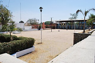
Cuajinicuilapa is the head town of the municipality of the same name in the Costa Chica region of the Mexican state of Guerrero. A low-lying area, it borders the Pacific Ocean and the state of Oaxaca. The municipality has the state's largest population of Afro-Mexicans with most of the population of this ethnicity. The town and municipality are highly socioeconomically marginalized and it is the poorest municipality of the state, with the economy dependent on livestock and fishing.
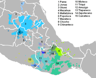
Tlapanec, or Meꞌphaa, is an indigenous Mexican language spoken by more than 98,000 Tlapanec people in the state of Guerrero. Like other Oto-Manguean languages, it is tonal and has complex inflectional morphology. The ethnic group themselves refer to their ethnic identity and language as Me̱ꞌpha̱a̱.
In linguistics, the pegative case is a hypothetical grammatical case that prototypically marks the agent of an action of giving.

The Matrícula de Tributos is a 16th-century central Mexican manuscript on amatl paper, listing the tributes paid by the various tributaries of the Aztec Empire. The manuscript is composed of 16 pages with likely more being lost to time, measuring 42 centimeters high and 29 centimeters wide. The dating of the Matrícula has been a subject of debate as to whether it dates to pre-Columbian or early colonial times, if truly being pre-Columbian then it'd be the only surviving preconquest Aztec manuscript.
Søren Wichmann is a Danish linguist specializing in historical linguistics, linguistic typology, Mesoamerican languages, and epigraphy. Since June 2016, he has been employed as a University Lecturer at Leiden University Centre for Linguistics, Leiden University, after having worked at different institutions in Denmark, Mexico, Germany and Russia, including, during 2003-2015, the Department of Linguistics, Max Planck Institute for Evolutionary Anthropology.

DYN was an art magazine founded by the Austrian-Mexican Surrealist Wolfgang Paalen, published in Mexico City, and distributed in New York City, and London between 1942 and 1944. Only six issues were produced.

Tlapa de Comonfort, often shortened to Tlapa and known as Tindaꞌi in Mixtec, is a city in the mountain region of the Mexican state of Guerrero. It also serves as the municipal seat for the surrounding municipality of the same name.
San Luis Acatlán is the seat of the municipality of San Luis Acatlán, located in the Mexican state of Guerrero. It is located in the Costa Chica region of the state, about 158 km from Acapulco. Most often called simply "Acatlán", the name comes from the locality of Acatlán located in the modern state of Puebla. The name itself derives from Nahuatl, meaning "among the reeds". Indigenous shepherds from Puebla arrived to this place between two rivers in Guerrero around 1750. San Luis derives from the name it was given in 1522 when soldiers of Pedro de Alvarado arrived here on this saint's day.

Azoyú is a municipality in the Mexican state of Guerrero. The municipal seat lies at Azoyu. The municipality covers an area of 784.6 km².
Juchitán is a municipality in the Mexican state of Guerrero. The municipal seat lies at Juchitán. Founded in 2004, it is one of the newest municipalities in Guerrero.

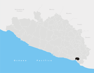
San Luis Acatlán is a municipality in the Mexican state of Guerrero. The municipal seat lies at San Luis Acatlán. The municipality covers an area of 704.4 km².
Cuajinicuilapa is a municipality in the Mexican state of Guerrero. The municipal seat lies at Cuajinicuilapa. The municipality covers an area of 857.1 km². In 2020, the municipality had a total population of 26,627, up from 25,537 in 2005.

Tropical Storm Carlos was the first of five tropical cyclones to make landfall during the 2003 Pacific hurricane season. It formed on June 26 from a tropical wave to the south of Mexico. It quickly strengthened as it approached the coast, and early on June 27 Carlos moved ashore in Oaxaca with winds of 65 mph (105 km/h). The storm rapidly deteriorated to a remnant low, which persisted until dissipating on June 29. Carlos brought heavy rainfall to portions of southern Mexico, peaking at 337 mm (13.3 in) in two locations in Guerrero. Throughout its path, the storm damaged about 30,000 houses, with a monetary damage total of 86.7 million pesos. At least nine people were killed throughout the country, seven due to mudslides and two from river flooding; there was also a report of two missing fishermen.

Huamelulpan is an archaeological site of the Mixtec culture, located in the town of San Martín Huamelulpan at an elevation of 2,218 metres (7,277 ft), about 96 kilometres (60 mi) north-west of the city of Oaxaca, the capital of Oaxaca state.
The 2011 Guerrero earthquake struck with a moment magnitude of 5.7 in southern Mexico at on 5 May. It was positioned west of Ometepec, Guerrero, with a focal depth of 24 km (14.9 mi), and was lightly felt in many adjacent areas.
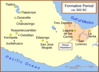
Regional communications in ancient Mesoamerica are believed to have been extensive. There were various trade routes attested since prehistoric times. In this article, especially the routes starting in the Mexico Central Plateau, and going down to the Pacific coast will be considered. These contacts then went on as far as Central America.

Mesoamerican codices are manuscripts that present traits of the Mesoamerican indigenous pictoric tradition, either in content, style, or in regards to their symbolic conventions. The unambiguous presence of Mesoamerican writing systems in some of these documents is also an important, but not defining, characteristic, for Mesoamerican codices can comprise pure pictorials, native cartographies with no traces of glyphs on them, or colonial alphabetic texts with indigenous illustrations. Perhaps the best-known examples among such documents are Aztec codices, Maya codices, and Mixtec codices, but other cultures such as the Tlaxcaltec, the Purépecha, the Otomi, the Zapotecs, and the Cuicatecs, are creators of equally relevant manuscripts. The destruction of Mesoamerican civilizations resulted in only about twenty known pre-Columbian codices surviving to modern times.

