Baggs, Wyoming | |
---|---|
Coordinates: 41°2′8″N107°39′27″W / 41.03556°N 107.65750°W | |
Country | United States |
State | Wyoming |
County | Carbon |
Area | |
• Total | 0.51 sq mi (1.32 km2) |
• Land | 0.51 sq mi (1.31 km2) |
• Water | 0.00 sq mi (0.01 km2) |
Elevation | 6,247 ft (1,904 m) |
Population | |
• Total | 440 |
417 | |
• Density | 825.74/sq mi (318.59/km2) |
Time zone | UTC-7 (Mountain (MST)) |
• Summer (DST) | UTC-6 (MDT) |
ZIP code | 82321 |
Area code | 307 |
FIPS code | 56-04740 [4] |
GNIS feature ID | 1585049 [5] |
Website | www |
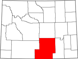
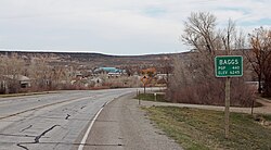
Baggs is a town in Carbon County, Wyoming, United States. The population was 411 at the 2020 census. [6] Baggs is home to the Outlaw Stop, a branch of the Little Snake River Museum, which is headquartered in Savery. [7]
Baggs is located at 41°2′8″N107°39′27″W / 41.03556°N 107.65750°W (41.035575, -107.657399). [8]
According to the United States Census Bureau, the town has a total area of 0.51 square miles (1.32 km2), all land. [9]
Census | Pop. | Note | %± |
---|---|---|---|
1920 | 200 | — | |
1930 | 192 | −4.0% | |
1940 | 221 | 15.1% | |
1950 | 206 | −6.8% | |
1960 | 199 | −3.4% | |
1970 | 146 | −26.6% | |
1980 | 433 | 196.6% | |
1990 | 272 | −37.2% | |
2000 | 348 | 27.9% | |
2010 | 440 | 26.4% | |
2019 (est.) | 417 | [3] | −5.2% |
U.S. Decennial Census [10] |
As of the 2010 Census, [2] there were 440 people, 183 households, and 114 families living in the town. The population density was 862.7 inhabitants per square mile (333.1/km2). There were 223 housing units at an average density of 437.3 per square mile (168.8/km2). The ethnic makeup of the town was 94.1% White, 0.5% Native American, 0.2% Asian, 4.8% from other races, and 0.5% from two or more ethnic groups. Hispanic or Latino of any ethnic groups were 11.4% of the population.
There were 183 households, of which 34.4% had children under the age of 18 living with them, 49.7% were married couples living together, 7.7% had a female householder with no husband present, 4.9% had a male householder with no wife present, and 37.7% were non-families. 30.1% of all households were made up of individuals, and 7.7% had someone living alone who was 65 years of age or older. The average household size was 2.40 and the average family size was 3.01.
The median age in the town was 34.3 years. 27% of residents were under the age of 18; 8.5% were between the ages of 18 and 24; 25.9% were from 25 to 44; 28.2% were from 45 to 64; and 10.5% were 65 years of age or older. The gender makeup of the town was 52.7% male and 47.3% female.
As of the census [4] of 2000, there were 348 people, 147 households, and 88 families living in the town. The population density was 705.8 people per square mile (274.2/km2). There were 197 housing units at an average density of 399.6 per square mile (155.2/km2). The racial makeup of the town was 94.83% White, 2.59% Native American, 0.29% Asian, 1.72% from other races, and 0.57% from two or more races. Hispanic or Latino of any race were 5.17% of the population.
There were 147 households, out of which 32.0% had children under the age of 18 living with them, 44.9% were married couples living together, 9.5% had a female householder with no husband present, and 40.1% were non-families. 29.3% of all households were made up of individuals, and 10.9% had someone living alone who was 65 years of age or older. The average household size was 2.37 and the average family size was 2.97.
In the town, the population was spread out, with 26.1% under the age of 18, 6.3% from 18 to 24, 31.0% from 25 to 44, 25.6% from 45 to 64, and 10.9% who were 65 years of age or older. The median age was 39 years. For every 100 females, there were 112.2 males. For every 100 females age 18 and over, there were 100.8 males.
The median income for a household in the town was $29,688, and the median income for a family was $38,250. Males had a median income of $32,031 versus $21,250 for females. The per capita income for the town was $20,812. About 7.9% of families and 14.9% of the population were below the poverty line, including 8.4% of those under age 18 and 10.8% of those age 65 or over.
This climatic region is typified by large seasonal temperature differences, with warm to hot (and often humid) summers and cold (sometimes severely cold) winters. According to the Köppen climate classification system, Baggs has a humid continental climate, abbreviated Dfb on climate maps. [11]
Climate data for Baggs, Wyoming (1991–2020 normals, extremes 1979–present) | |||||||||||||
---|---|---|---|---|---|---|---|---|---|---|---|---|---|
Month | Jan | Feb | Mar | Apr | May | Jun | Jul | Aug | Sep | Oct | Nov | Dec | Year |
Record high °F (°C) | 55 (13) | 61 (16) | 75 (24) | 83 (28) | 93 (34) | 104 (40) | 99 (37) | 100 (38) | 92 (33) | 82 (28) | 77 (25) | 59 (15) | 104 (40) |
Mean maximum °F (°C) | 44.3 (6.8) | 49.0 (9.4) | 63.6 (17.6) | 73.3 (22.9) | 81.7 (27.6) | 89.6 (32.0) | 93.5 (34.2) | 91.3 (32.9) | 85.6 (29.8) | 75.1 (23.9) | 60.2 (15.7) | 47.4 (8.6) | 93.3 (34.1) |
Mean daily maximum °F (°C) | 32.2 (0.1) | 36.5 (2.5) | 48.3 (9.1) | 57.8 (14.3) | 67.9 (19.9) | 79.4 (26.3) | 86.7 (30.4) | 83.9 (28.8) | 74.5 (23.6) | 59.9 (15.5) | 44.6 (7.0) | 33.2 (0.7) | 58.7 (14.8) |
Daily mean °F (°C) | 19.6 (−6.9) | 24.2 (−4.3) | 35.3 (1.8) | 43.4 (6.3) | 52.1 (11.2) | 61.2 (16.2) | 68.0 (20.0) | 65.8 (18.8) | 57.1 (13.9) | 44.6 (7.0) | 31.7 (−0.2) | 21.2 (−6.0) | 43.7 (6.5) |
Mean daily minimum °F (°C) | 7.0 (−13.9) | 12.0 (−11.1) | 22.4 (−5.3) | 28.9 (−1.7) | 36.2 (2.3) | 43.1 (6.2) | 49.2 (9.6) | 47.7 (8.7) | 39.7 (4.3) | 29.3 (−1.5) | 18.8 (−7.3) | 9.2 (−12.7) | 28.6 (−1.9) |
Mean minimum °F (°C) | −16.6 (−27.0) | −11.5 (−24.2) | 5.0 (−15.0) | 15.9 (−8.9) | 24.1 (−4.4) | 32.0 (0.0) | 40.7 (4.8) | 37.2 (2.9) | 26.3 (−3.2) | 12.7 (−10.7) | −2.3 (−19.1) | −13.8 (−25.4) | −21.4 (−29.7) |
Record low °F (°C) | −50 (−46) | −47 (−44) | −22 (−30) | −2 (−19) | 9 (−13) | 20 (−7) | 31 (−1) | 28 (−2) | 1 (−17) | −7 (−22) | −26 (−32) | −39 (−39) | −50 (−46) |
Average precipitation inches (mm) | 0.72 (18) | 0.76 (19) | 0.71 (18) | 1.11 (28) | 1.77 (45) | 0.77 (20) | 0.87 (22) | 0.90 (23) | 1.09 (28) | 1.07 (27) | 0.70 (18) | 0.70 (18) | 11.17 (284) |
Average snowfall inches (cm) | 6.9 (18) | 6.5 (17) | 2.9 (7.4) | 0.9 (2.3) | 0.5 (1.3) | 0.0 (0.0) | 0.0 (0.0) | 0.0 (0.0) | 0.2 (0.51) | 1.6 (4.1) | 5.3 (13) | 5.7 (14) | 30.5 (77) |
Average precipitation days (≥ 0.01 in) | 3.7 | 2.6 | 2.2 | 3.9 | 4.3 | 2.8 | 3.1 | 3.6 | 3.5 | 3.4 | 2.4 | 3.1 | 38.6 |
Average snowy days (≥ 0.1 in) | 3.4 | 2.3 | 1.2 | 0.6 | 0.3 | 0.0 | 0.0 | 0.0 | 0.0 | 0.6 | 1.4 | 3.1 | 12.9 |
Source: NOAA [12] [13] |
Public education in the town of Baggs is provided by Carbon County School District #1. Little Snake River Valley School, a K-12 campus, serves the town.
Baggs has a public library, a branch of the Carbon County Library System. [14]
Goldsboro is a town in Caroline County, Maryland, United States.The population was 246 at the 2010 United States Census. The zip code is 21636. First known as Oldtown, it was renamed in 1870 for the prominent Goldsborough family who owned land in the area. Castle Hall was listed on the National Register of Historic Places in 1975.
South Corning is a village in Steuben County, New York, United States. The population was 1,145 at the 2010 census. The village is in the town of the same name.
Hollow Rock is a town in Carroll County, Tennessee, United States. The population was 718 at the 2010 census. Hollow Rock is just west of, and adjacent to, the town of Bruceton and is 70 km (43 mi) northeast of Jackson.
New Martinsville is a city in and the county seat of Wetzel County, West Virginia, United States, along the Ohio River. The population was 5,186 at the 2020 census.
Oceana is a town in Wyoming County, West Virginia. The population was 1,462 at the time of the 2020 census. Oceana is the oldest city in Wyoming County and was the county seat until 1907.
Basin is a town in, and the county seat of, Big Horn County, Wyoming, United States. The population was 1,288 at the 2020 census. The community is located near the center of the Bighorn Basin with the Big Horn River east of the town. Basin's post office, built in 1919, is listed on the National Register of Historic Places.
Deaver is a town in Big Horn County, Wyoming, United States. The population was 178 at the 2010 census.
Lovell is the largest town in Big Horn County, Wyoming, United States. The population was 2,243 at the 2020 census.
Pine Haven is a town in Crook County, Wyoming, United States. The population was 493 at the 2020 census.
Fort Laramie is a town in Goshen County, Wyoming, United States. The population was 206 at the 2020 census. The town is named after historic Fort Laramie, an important stop on the Oregon, California and Mormon trails, as well as a staging point for various military excursions and treaty signings. The old fort was located south of town across the North Platte River, at the mouth of the Laramie River.
Pine Bluffs is a town in eastern Laramie County, Wyoming, United States. It is located on the county's border with Nebraska. Pine Bluffs is part of the Cheyenne, Wyoming, Metropolitan Statistical Area. The population was 1,129 at the 2010 census. It was first known as Rock Ranch, but the name was changed by railroad officials for the pines on the nearby bluffs.
Alcova is a census-designated place (CDP) in Natrona County, Wyoming, United States. It is part of the Casper, Wyoming Metropolitan Statistical Area. The population was 34 at the 2020 census. Wyoming's center of population is located in the small Town of Alcova. Alcova and the nearby reservoir, Alcova Lake, are popular vacation spots with many seasonal residents.
Midwest is a town in Natrona County, Wyoming, United States. It is part of the Casper, Wyoming Metropolitan Statistical Area. The population was 285 at the 2020 census.
Garland is a census-designated place (CDP)in Park County, Wyoming, United States. The population was 115 at the 2010 census.
Clearmont is a town in Sheridan County, Wyoming, United States. The population was 142 at the 2010 census.
Dayton is a town in Sheridan County, Wyoming, United States. The population was 822 at the 2020 census.
Bairoil is a town in Sweetwater County, Wyoming, United States. The population was 68 at the 2020 census.
Wamsutter is a town in Sweetwater County, Wyoming, United States. The population was 203 at the 2020 census.
Worland is a city in Washakie County, Wyoming, United States. The population was 4,773 at the 2020 census, down from 5,487 at the 2010 census. It is the county seat of Washakie County. It is located within the Big Horn Basin and along the Big Horn River in northwestern Wyoming.
Upton is a town in Weston County, Wyoming, United States. The population was 898 at the 2020 census. The slogan of the town is: "The best town on earth".