
Palenque, also anciently known in the Itza Language as Lakamhaʼ, was a Maya city state in southern Mexico that perished in the 8th century. The Palenque ruins date from ca. 226 BC to ca. 799 AD. After its decline, it was overgrown by the jungle of cedar, mahogany, and sapodilla trees, but has since been excavated and restored. It is located near the Usumacinta River in the Mexican state of Chiapas, about 130 km (81 mi) south of Ciudad del Carmen, 150 meters (490 ft) above sea level. It is adjacent to the modern town of Palenque, Chiapas. It averages a humid 26 °C (79 °F) with roughly 2,160 millimeters (85 in) of rain a year.
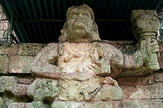
Copán is an archaeological site of the Maya civilization in the Copán Department of western Honduras, not far from the border with Guatemala. It is one of the most important sites of the Maya civilization, which was not excavated until the 19th century. The ruined citadel and imposing public squares reveal the three main stages of development before the city was abandoned in the early 10th century.

Mayapan is a Pre-Columbian Maya site a couple of kilometers south of the town of Telchaquillo in Municipality of Tecoh, approximately 40 km south-east of Mérida and 100 km west of Chichen Itza; in the state of Yucatán, Mexico. Mayapan was the political and cultural capital of the Maya in the Yucatán Peninsula during the Late Post-Classic period from the 1220s until the 1440s. Estimates of the total city population are 15,000–17,000 people, and the site has more than 4,000 structures within the city walls, and additional dwellings outside.

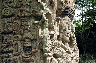
Quiriguá (Spanish pronunciation:[kiɾiˈɣwa]) is an ancient Maya archaeological site in the department of Izabal in south-eastern Guatemala. It is a medium-sized site covering approximately 3 square kilometres (1.2 sq mi) along the lower Motagua River, with the ceremonial center about 1 km (0.6 mi) from the north bank. During the Maya Classic Period (AD 200–900), Quiriguá was situated at the juncture of several important trade routes. The site was occupied by 200, construction on the acropolis had begun by about 550, and an explosion of grander construction started in the 8th century. All construction had halted by about 850, except for a brief period of reoccupation in the Early Postclassic (c. 900 – c. 1200). Quiriguá shares its architectural and sculptural styles with the nearby Classic Period city of Copán, with whose history it is closely entwined.

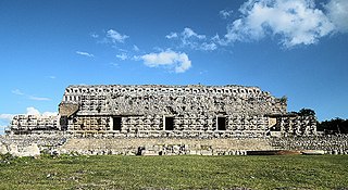
Uxmal is an ancient Maya city of the classical period located in present-day Mexico. It is considered one of the most important archaeological sites of Maya culture, along with Palenque, Chichen Itza and Calakmul in Mexico, Caracol and Xunantunich in Belize, and Tikal in Guatemala. It is located in the Puuc region of the western Yucatán Peninsula, and is considered one of the Maya cities most representative of the region's dominant architectural style. It was designated a UNESCO World Heritage Site along with the nearby ruins of Kabah, Sayil and Labna.

Labna is a Mesoamerican archaeological site and ceremonial center of the pre-Columbian Maya civilization, located in the Puuc Hills region of the Yucatán Peninsula. It is situated to the south of the large Maya site of Uxmal, in the southwest of the present-day state of Yucatán, Mexico. Labna, Sayil and Kabah were incorporated with Uxmal as a UNESCO World Heritage Site in 1996.
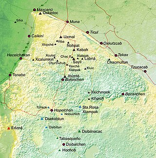
Puuc is the name of either a region in the Mexican state of Yucatán or a Maya architectural style prevalent in that region. The word puuc is derived from the Maya term for "hill". Since the Yucatán is relatively flat, this term was extended to encompass the large karstic range of hills in the southern portion of the state, hence, the terms Puuc region or Puuc hills. The Puuc hills extend into northern Campeche and western Quintana Roo.
Kabah is a Maya archaeological site in the Puuc region of western Yucatan, south of Mérida. It was incorporated together with Uxmal, Sayil and Labna as a UNESCO World Heritage Site in 1996.

Sayil was a pre-Columbian city built by the Maya people of the Terminal Classic period. It is located in the Mexican state of Yucatán, in the southwest of the state, south of Uxmal. Sayil, Kabah and Labna were incorporated together with Uxmal as a UNESCO World Heritage Site in 1996.
Izapa is a very large pre-Columbian archaeological site located in the Mexican state of Chiapas; it is best known for its occupation during the Late Formative period. The site is situated on the Izapa River, a tributary of the Suchiate River, near the base of the volcano Tacaná, the sixth tallest mountain in Mexico.

La Mojarra Stela 1 is a Mesoamerican carved monument (stela) dating from 156 CE. It was discovered in 1986, pulled from the Acula River near La Mojarra, Veracruz, Mexico, not far from the Tres Zapotes archaeological site. The 4+1⁄2-foot-wide (1.4 m) by 6+1⁄2-foot-high (2.0 m), four-ton limestone slab contains about 535 glyphs of the Isthmian script. One of Mesoamerica's earliest known written records, this Epi-Olmec culture monument not only recorded this ruler's achievements, but placed them within a cosmological framework of calendars and astronomical events.

Mesoamerican architecture is the set of architectural traditions produced by pre-Columbian cultures and civilizations of Mesoamerica, traditions which are best known in the form of public, ceremonial and urban monumental buildings and structures. The distinctive features of Mesoamerican architecture encompass a number of different regional and historical styles, which however are significantly interrelated. These styles developed throughout the different phases of Mesoamerican history as a result of the intensive cultural exchange between the different cultures of the Mesoamerican culture area through thousands of years. Mesoamerican architecture is mostly noted for its pyramids, which are the largest such structures outside of Ancient Egypt.
Ancient Maya art comprises the visual arts of the Maya civilization, an eastern and south-eastern Mesoamerican culture made up of a great number of small kingdoms in present-day Mexico, Guatemala, Belize and Honduras. Many regional artistic traditions existed side by side, usually coinciding with the changing boundaries of Maya polities. This civilization took shape in the course of the later Preclassic Period, when the first cities and monumental architecture started to develop and the hieroglyphic script came into being. Its greatest artistic flowering occurred during the seven centuries of the Classic Period.

Oxkintok is a pre-Columbian Maya archaeological site in the Puuc region of Yucatán state, in southeastern Mexico.

Kʼahkʼ Pulaj Chan Chaahk, also known as Lord Chac before the decipherment of his corresponding name glyphs, is currently the only archaeologically identified ruler of the pre-Columbian Maya polity at Uxmal, who ruled in the early 10th century. Only a handful of details are known from this king, as hieroglyphic inscriptions, while very prominent in the Southern Maya Lowlands, are scarce in the north. What is known is that Lord Chac acceded to the throne somewhere at the end of the 9th century. During his rule, between 890-910 AD, some of the largest and most impressive buildings in Uxmal, such as the so-called Nunnery Quadrangle and the Governor's Palace, were built. An inscription at a large ballcourt in Uxmal, for playing the Mesoamerican ballgame, informs us it was dedicated in 901 during the reign of this king.

The Maya civilization was a Mesoamerican civilization that existed from antiquity to the early modern period. It is known by its ancient temples and glyphs (script). The Maya script is the most sophisticated and highly developed writing system in the pre-Columbian Americas. The civilization is also noted for its art, architecture, mathematics, calendar, and astronomical system.

Chichén Itzá was a large pre-Columbian city built by the Maya people of the Terminal Classic period. The archeological site is located in Tinúm Municipality, Yucatán State, Mexico.

Xlapak is a small Maya archaeological site in the Yucatan Peninsula of southeastern Mexico. It is located in the heart of the Puuc region, about 4 kilometres (2.5 mi) from the archaeological site of Labná and a similar distance from Sayil, lying directly between the two sites. It consists of three main groups in a valley of the Puuc Hills in Yucatán State, a region of karst limestone forming the only major topographical feature of the peninsula. The closest town is Oxkutzcab, about 30 kilometres (19 mi) to the northeast.
Maya stelae are monuments that were fashioned by the Maya civilization of ancient Mesoamerica. They consist of tall, sculpted stone shafts and are often associated with low circular stones referred to as altars, although their actual function is uncertain. Many stelae were sculpted in low relief, although plain monuments are found throughout the Maya region. The sculpting of these monuments spread throughout the Maya area during the Classic Period, and these pairings of sculpted stelae and circular altars are considered a hallmark of Classic Maya civilization. The earliest dated stela to have been found in situ in the Maya lowlands was recovered from the great city of Tikal in Guatemala. During the Classic Period almost every Maya kingdom in the southern lowlands raised stelae in its ceremonial centre.

Las Choapas is a recently found archaeological site located within the municipality of Las Choapas, in the southeastern border of the Veracruz State, inside the San Miguel de Allende Ejido, bordering the municipalities of Huimanguillo, Tabasco and Ostuacán, in Chiapas.

