
Hollywood Cemetery is a historic rural cemetery located at 412 South Cherry Street in the Oregon Hill neighborhood of Richmond, Virginia. It was established in 1847 and designed by the landscape architect John Notman. It is 135-acres in size and overlooks the James River. It is the only cemetery other than Arlington National Cemetery that contains the burials of two United States Presidents, James Monroe and John Tyler.

Ginter Park is a suburban neighborhood of Richmond, Virginia built on land owned and developed by Lewis Ginter. The neighborhood's first well known resident was newspaperman Joseph Bryan, who lived in Laburnum, first built in 1883 and later rebuilt. In 1895, many acres of land north of Richmond were purchased by Ginter in order to develop into neighborhoods. Ginter Park and other neighborhoods were developed from this initial land purchase. In Ginter Park are Union Presbyterian Seminary and as well as Pollard Park.
Seven Pines National Cemetery is a national cemetery located in the Seven Pines area of the unincorporated town of Sandston in Henrico County, Virginia. Cemetery records state the name is derived from for a group of seven pine trees planted within the national cemetery in 1869 near the intersection of the old Williamsburg-Richmond Stage Road and the Nine Mile Road, however, the name Seven Pines pre-dates the establishment of the cemetery.

Alexandria National Cemetery is a United States National Cemetery, of approximately 5.5 acres (2.2 ha), located in the city of Alexandria, Virginia. Administered by the United States Department of Veterans Affairs, it is one of the original national cemeteries that were established in 1862. As of 2014, it was site to over 4,500 interments. The cemetery can accommodate the cremated remains of eligible individuals.

Cold Harbor National Cemetery is a United States National Cemetery in Mechanicsville, Hanover County, Virginia. It encompasses 1.4 acres (5,700 m2), and as of the end of 2005, had 2,110 interments. Administered by the United States Department of Veterans Affairs, it is managed by the Hampton National Cemetery.
Fort Harrison National Cemetery is a United States National Cemetery located seven miles (11 km) south of the city of Richmond, in Henrico County, Virginia. Administered by the United States Department of Veterans Affairs, It encompasses 1.5 acres (0.61 ha), and as of the end of 2005, had 1,570 interments.

Glendale National Cemetery is a United States National Cemetery located near the city of Richmond, in Henrico County, Virginia. Administered by the United States Department of Veterans Affairs, it encompasses 2.1 acres (0.85 ha), and as of the end of 2005 had 2,064 interments. It is closed to new interments.

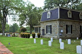
Richmond National Cemetery is a United States National Cemetery three miles (4.8 km) east of Richmond in Henrico County, Virginia. Administered by the United States Department of Veterans Affairs, it encompasses 9.7 acres (3.9 ha), and as of 2021 had more than 11,000 interments. It is closed to new interments. Richmond National Cemetery was listed on the National Register of Historic Places in 1995.

Shockoe Bottom historically known as Shockoe Valley, is an area in Richmond, Virginia, just east of downtown, along the James River. Located between Shockoe Hill and Church Hill, Shockoe Bottom contains much of the land included in Colonel William Mayo's 1737 plan of Richmond, making it one of the city's oldest neighborhoods.

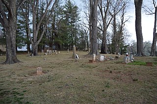
The Hebrew Cemetery in Richmond, Virginia, also known as Hebrew Burying Ground, and previously the Jew's Burying Ground, dates from 1816. This Jewish cemetery, one of the oldest in the United States, was founded in 1816 as successor to the Franklin Street Burial Grounds of 1789. Among those interred here is Josephine Cohen Joel, who was well known in the early 20th century as the founder of Richmond Art Co. Within Hebrew Cemetery is a plot known as the Soldier's Section. It contains the graves of 30 Jewish Confederate soldiers who died in or near Richmond. It is one of only two Jewish military cemeteries outside of the State of Israel.
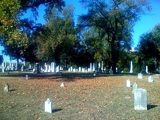
The Shockoe Hill Cemetery is a historic cemetery located on Shockoe Hill in Richmond, Virginia.

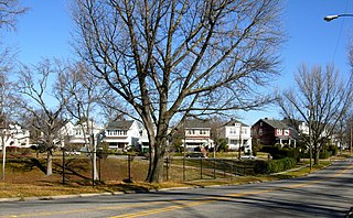
Barton Heights is a streetcar suburb neighborhood and former town in the Northside area of Richmond, Virginia. The area was primarily developed between 1890 and the 1920s.

The Contrabands and Freedmen Cemetery at 1001 S. Washington St. in Alexandria, Virginia was listed on the National Register of Historic Places on August 15, 2012. It was established in February 1864 by the Union military commander of the Alexandria District for use as a cemetery for the burial of African Americans who had escaped slavery, known as contrabands and freedmen. During early Reconstruction, it was operated by the Freedmen's Bureau. It was closed in late 1868, after Congress ended most operations of the Bureau. The last recorded burial was made in January 1869.
Daughters of Zion Cemetery, also known as Zion Cemetery, Society Cemetery, and Old Oakwood Section, is a historic African-American cemetery located at Charlottesville, Virginia, United States. It was established in 1873, and contains an estimated 300 burial sites with 152 of the burials commemorated with 136 surviving grave markers. It consists exclusively of marble and granite grave markers with a single 20 foot by 20 foot section enclosed with a cast-iron fence. Notable burials include Benjamin Tonsler (1854–1917), who built the Benjamin Tonsler House. The city assumed title to the property in the 1970s, and the last burial occurred in 1995.

The Brookland Park Historic District is a national historic district located at Richmond, Virginia. The district encompasses 1,157 contributing buildings located north of downtown Richmond and Barton Heights.
The Battery Court Historic District is a national historic district located at Richmond, Virginia. The district encompasses 549 contributing buildings and 1 contributing site located north of downtown Richmond and west of Barton Heights and Brookland Park. The primarily residential area developed starting in the early-20th century as one of the city's early “streetcar suburbs.” The buildings are in a variety of popular late-19th and early-20th century architectural styles including frame bungalows, American Foursquare, Colonial Revival, Tudor Revival, and Mission Revival. Notable non-residential buildings include the Overbrook Presbyterian Church and Battery Park Christian Church.
The Shockoe Hill African Burying Ground was established by the city of Richmond, Virginia, for the interment of free people of color, and the enslaved. The heart of this now invisible burying ground is located at 1305 N 5th St.

The Shockoe Hill Burying Ground Historic District, located in the city of Richmond, Virginia, is a significant example of a municipal almshouse-public hospital-cemetery complex of the sort that arose in the period of the New Republic following disestablishment of the Anglican Church. The District illustrates changing social and racial relationships in Richmond through the New Republic, Antebellum, Civil War, Reconstruction, and Jim Crow/Lost Cause eras of the nineteenth and twentieth centuries. The Shockoe Hill Burying Ground Historic District occupies 43 acres (17 ha) of land bounded to the south by E. Bates Street, to the north by the northern limit of the Virginia Passenger Rail Authority right-of-way at the southern margin of the Bacon's Quarter Branch valley, to the west by 2nd Street, and to the east by the historic edge of the City property at the former location of Shockoe Creek. The District encompasses most of a 28.5-acre (11.5 ha) tract acquired by the city of Richmond in 1799 to fulfill several municipal functions, along with later additions to this original tract.
The city of Richmond, Virginia has two African Burial Grounds, the "Shockoe Bottom African Burial Ground", and the "Shockoe Hill African Burying Ground". Additionally the city is home to several other important and historic African American cemeteries.


