Bartramia (bird)

Last updated

Bartramia
Temporal range: Pliocene - Recent
BATITU Bartramia longicauda.jpg
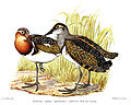
Upland sandpiper (Bartramia longicauda)
Scientific classification OOjs UI icon edit-ltr.svg
Domain: Eukaryota
Kingdom: Animalia
Phylum: Chordata
Class: Aves
Order: Charadriiformes
Family: Scolopacidae
Subfamily: Tringinae
Genus: Bartramia
Lesson, 1831
Species

Bartramia is a genus of bird containing two species, the extant upland sandpiper and the extinct Bartramia umatilla from the Middle Pliocene of Oregon. [1] [2]

Related Research Articles

<span class="mw-page-title-main">Falcon</span> Birds of prey in the genus Falco

Falcons are birds of prey in the genus Falco, which includes about 40 species. Falcons are widely distributed on all continents of the world except Antarctica, though closely related raptors did occur there in the Eocene.

<span class="mw-page-title-main">Umatilla County, Oregon</span> County in Oregon, United States

Umatilla County is one of the 36 counties in the U.S. state of Oregon. The population of 81,826 ranks it as the 14th largest in Oregon, and largest in Eastern Oregon. Hermiston is the largest city in Umatilla County, but Pendleton remains the county seat. Umatilla County is part of the Hermiston-Pendleton, OR Micropolitan Statistical Area, which has a combined population of 94,833. It is included in the eight-county definition of Eastern Oregon.

<span class="mw-page-title-main">Umatilla, Oregon</span> City in Oregon, United States

Umatilla is a city in Umatilla County, Oregon, United States. The population in 2010 was 6,906, but the city's population includes approximately 2,000 inmates incarcerated at Two Rivers Correctional Institution.

<span class="mw-page-title-main">Cormorant</span> Family of aquatic birds

Phalacrocoracidae is a family of approximately 40 species of aquatic birds commonly known as cormorants and shags. Several different classifications of the family have been proposed, but in 2021 the International Ornithologists' Union (IOU) adopted a consensus taxonomy of seven genera. The great cormorant and the common shag are the only two species of the family commonly encountered in Britain and Ireland and "cormorant" and "shag" appellations have been later assigned to different species in the family somewhat haphazardly.

<span class="mw-page-title-main">Upland sandpiper</span> Species of bird

The upland sandpiper is a large sandpiper, closely related to the curlews. Older names are the upland plover and Bartram's sandpiper. In Louisiana, it is also colloquially known as the papabotte. It is the only member of the genus Bartramia. The genus name and the old common name Bartram's sandpiper commemorate the American naturalist William Bartram. The species name longicauda is from Latin longus, "long" and caudus, "tail". The name "Bartram's sandpiper" was made popular by Alexander Wilson, who was taught ornithology and natural history illustration by Bartram.

<i>Branta</i> Genus of birds

The black geese of the genus Branta are waterfowl belonging to the true geese and swans subfamily Anserinae. They occur in the northern coastal regions of the Palearctic and all over North America, migrating to more southernly coasts in winter, and as resident birds in the Hawaiian Islands. Alone in the Southern Hemisphere, a self-sustaining feral population derived from introduced Canada geese is also found in New Zealand.

<i>Anas</i> Genus of birds

Anas is a genus of dabbling ducks. It includes the pintails, most teals, and the mallard and its close relatives. It formerly included additional species but following the publication of a molecular phylogenetic study in 2009 the genus was split into four separate genera. The genus now contains 31 living species. The name Anas is the Latin for "duck".

<span class="mw-page-title-main">Blue Mountains (Pacific Northwest)</span> Mountain range in Oregon and Washington, United States

The Blue Mountains are a mountain range in the northwestern United States, located largely in northeastern Oregon and stretching into extreme southeastern Washington. The range has an area of about 15,000 square miles (39,000 km2), stretching east and southeast of Pendleton, Oregon, to the Snake River along the Oregon–Idaho border.

The Umatilla Indian Reservation is an Indian reservation in the Pacific Northwest of the United States. It was created by The Treaty of June 9, 1855 between the United States and members of the Walla, Cayuse, and Umatilla tribes. It lies in northeastern Oregon, east of Pendleton. The reservation is mostly in Umatilla County, with a very small part extending south into Union County. It is managed by the three Confederated Tribes of the Umatilla Indian Reservation.

<span class="mw-page-title-main">Umatilla Chemical Depot</span> U.S. Army installation that stored chemical weapons

The Umatilla Chemical Depot (UMCD), based in Umatilla, Oregon, was a U.S. Army installation in the United States that stored chemical weapons. The chemical weapons originally stored at the depot consisted of various live munitions and storage containers each holding 1 short ton GB or VX nerve agents or HD blister agent. All munitions had been safely destroyed by 2011 and base closure operations were still ongoing as of 2022.

<span class="mw-page-title-main">Great albatross</span> Genus of birds

The great albatrosses are seabirds in the genus Diomedea in the albatross family. The genus Diomedea formerly included all albatrosses except the sooty albatrosses, but in 1996 the genus was split, with the mollymawks and the North Pacific albatrosses both being elevated to separate genera.

<span class="mw-page-title-main">Umatilla National Forest</span> National forest in the U.S. states of Oregon and Washington

The Umatilla National Forest, in the Blue Mountains of northeast Oregon and southeast Washington, covers an area of 1.4 million acres (5,700 km2). In descending order of land area the forest is located in parts of Umatilla, Grant, Columbia, Morrow, Wallowa, Union, Garfield, Asotin, Wheeler, and Walla Walla counties. More than three-quarters of the forest lies in the state of Oregon. Forest headquarters are located in Pendleton, Oregon. There are local ranger district offices in Heppner and Ukiah in Oregon, and in Pomeroy and Walla Walla in Washington.

<span class="mw-page-title-main">North Fork Umatilla Wilderness</span>

The North Fork Umatilla Wilderness is a wilderness area located inside the Umatilla National Forest, in the Blue Mountains of northeastern Oregon. It is the smallest wilderness in northeast Oregon, encompassing only 20,144 acres (8,152 ha) in Umatilla and Union counties.

<span class="mw-page-title-main">Columbia Plateau (ecoregion)</span> Xeric shrubland ecoregion of Canada and the United States

The Columbia Plateau ecoregion is a Level III ecoregion designated by the United States Environmental Protection Agency (EPA) encompassing approximately 32,100 square miles (83,139 km2) of land within the U.S. states of Washington, Oregon, and Idaho. The ecoregion extends across a wide swath of the Columbia River Basin from The Dalles, Oregon to Lewiston, Idaho to Okanogan, Washington near the Canada–U.S. border. It includes nearly 500 miles (800 km) of the Columbia River, as well as the lower reaches of major tributaries such as the Snake and Yakima rivers and the associated drainage basins. It is named for the Columbia Plateau, a flood basalt plateau formed by the Columbia River Basalt Group during the late Miocene and early Pliocene. The arid sagebrush steppe and grasslands of the region are flanked by moister, predominantly forested, mountainous ecoregions on all sides. The underlying basalt is up to 2 miles (3 km) thick and partially covered by thick loess deposits. Where precipitation amounts are sufficient, the deep loess soils have been extensively cultivated for wheat. Water from the Columbia River is subject to resource allocation debates involving fisheries, navigation, hydropower, recreation, and irrigation, and the Columbia Basin Project has dramatically converted much of the region to agricultural use.

<span class="mw-page-title-main">Umatilla County Fair</span> Annual event in Oregon, United States

The Umatilla County Fair is a fair held in Hermiston in Umatilla County, Oregon. The fair runs from the middle of June through to the middle of August each year. It was started in August 1912 as the Hermiston Dairy and Hog Show as a joint fair with Morrow County, a one-time-only affair since legislation in 1913 made it no longer possible to have a bi-county fair.

<span class="mw-page-title-main">Umatilla National Wildlife Refuge</span> Protected area in Oregon and Washington, US

The Umatilla National Wildlife Refuge is located on and around the Columbia River about 15 miles (24 km) northwest of Hermiston, Oregon and includes 8,907 acres (3,605 ha) in Oregon, and 14,876 acres (6,020 ha) in Washington. It was established in 1969 to help mitigate habitat lose due to the flooding that occurred following the construction of the John Day Dam. The refuge is popular with birdwatchers and wildlife enthusiasts.

<span class="mw-page-title-main">Cold Springs National Wildlife Refuge</span> Protected area in Oregon, United States

Cold Springs National Wildlife Refuge is a 3,117-acre (12.61 km2) National Wildlife Refuge located 7 miles (10 km) northeast of Hermiston and 3 miles (5 km) south of the Columbia River in Umatilla County, Oregon; The refuge was established in 1909 as a preserve and breeding ground for native birds. It consists of diverse wetland habitats surrounded by upland habitat of big sagebrush and native steppe grasses. A riparian component of willow and cottonwood provides refuge for birds, mammals, and other animals.

McKay is an unincorporated community in Umatilla County, Oregon, United States. Its name accompanies McKay Creek, which is named for Dr. William Cameron McKay, located in Umatilla County at North McKay Creek Road on Ross Road.

The McKay Formation is a geologic formation in Oregon. It preserves fossils dating back to the Tortonian to Zanclean stages (Hemphillian) of the Neogene period.

References

  1. "Bartramia umatilla". Fossilworks.
  2. Brodkorb, P. (1958). "Birds from the Middle Pliocene of McKay, Oregon". The Condor. 60 (4): 252–255. doi:10.2307/1365194. JSTOR   1365194.