
The Central Park West Historic District is located along Central Park West, between 61st and 97th Streets, on the Upper West Side of Manhattan in New York City, United States. The district was added to the National Register of Historic Places on November 9, 1982. The district encompasses a portion of the Upper West Side-Central Park West Historic District as designated by the New York City Landmarks Preservation Commission, and contains a number of prominent New York City designated landmarks, including the Dakota, a National Historic Landmark. The buildings date from the late 19th century to the early 1940s and exhibit a variety of architectural styles. The majority of the district's buildings are of neo-Italian Renaissance style, but Art Deco is a popular theme as well.

The Central Square Historic District is a historic district encompassing much of the central business district of Stoneham, Massachusetts. It includes the town's largest concentration of 19th and early-20th century commercial architecture, in an area that developed in importance as a commercial center after the construction of the Andover-Medford Turnpike. The district was added to the National Register of Historic Places in 1990.
The Rogers Commercial Historic District, known informally as Historic Downtown Rogers, is a historic district in the central business district of Rogers, Arkansas. When it was first listed on the National Register of Historic Places in 1988, it was known as the Walnut Street Historic District; this was changed when the district was enlarged in 1993. The district encompasses a portion of the city's central business district, whose historical significance extends from about 1885 to the end of World War II.

The Argenta Historic District encompasses significant historic elements of central North Little Rock, Arkansas. The area that is now central North Little Rock was known as Argenta when it was first settled, and remained unincorporated until it was annexed to Little Rock in 1890. William Faucette, a leading Argenta politician and businessman, orchestrated the incorporation of North Little Rock just beyond the annexed area in 1901, and then made a successful petition to separate Argenta from Little Rock into the new municipality in 1903. Subsequent attempts to rename North Little Rock to Argenta have failed.
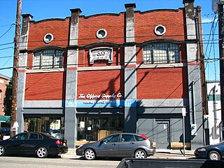
The East Portland Grand Avenue Historic District, located in southeast Portland, Oregon, is listed on the National Register of Historic Places. The district includes approximately 20 city blocks on or near Southeast Grand Avenue on the east side of the Willamette River, roughly bounded on the south by SE Main Street, north by SE Ankeny Street, west by SE Martin Luther King Jr. Boulevard, and east by SE Seventh Avenue. Most structures in the district are commercial buildings rising two to three stories. Immediately to the west of the historic district is Portland's east side industrial area, and to the east are industrial and residential areas.

St. Paul's Parish is a congregation of the Episcopal Church in Batesville, Arkansas. The parish was officially founded on March 3, 1866, by Bishop Henry C. Lay and the Rev. Charles H. Albert, who had been working as missionaries in the area since the previous year.

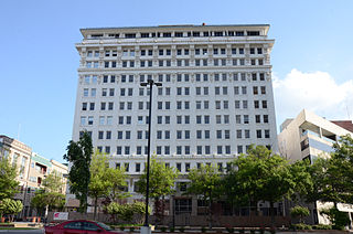
The El Dorado Commercial Historic District encompasses the historic commercial heart of downtown El Dorado, Arkansas. The city serves as the seat of Union County, and experienced a significant boom in growth during the 1920s, after oil was discovered in the area. The business district that grew in this time is anchored by the Union County Courthouse, at the corner of Main and Washington Streets, where the Confederate memorial is also located. The historic district listed on the National Register of Historic Places in 2003 includes the city blocks surrounding the courthouse, as well as several blocks extending east along Main Street and south along Washington Street. Most of the commercial buildings are one and two stories in height and are built of brick. Notable exceptions include the Exchange Bank building, which was, at nine stories, the county's first skyscraper, and the eight-story Murphy Oil building. There are more than forty contributing properties in the district.

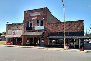
The Fordyce Commercial Historic District encompasses the historic heart of Fordyce, Arkansas, the county seat of Dallas County. It encompasses four city blocks of North Main Street, between 1st and 4th, and includes properties on these adjacent streets. Fordyce was founded in 1882, and the oldest building in the district, the Nutt-Trussell Building at 202 North Main Street, was built c. 1884. Spurred by the logging industry and the Cotton Belt Railroad, Fordyce's downtown area had 25 buildings by 1901, and continued to grow over the next few decades, resulting in a concentration of period commercial architecture in its downtown. The district was listed on the National Register of Historic Places in 2008.
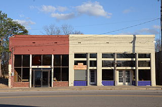
The Hartford Commercial Historic District encompasses about two blocks of buildings in the central business district of Hartford, Arkansas. Extending on the east side of Broadway from just north of Main Street to south of Ludlow Street, they are the only major commercial buildings left from Hartford's boom years of 1880–1920, when coal in the area was mined for use by the railroads. Most of the buildings are single-story brick structures, in typical early-20th-century commercial styles. Included in the district is Hartford's present city hall, which was built in 1910 as a theater.

The Cotton Plant Commercial Historic District encompasses the historic civic and commercial center of the city of Cotton Plant, Arkansas. It includes about two blocks of Main Street, between Elm and Ash on the south side, and between Pine and just short of Vine on the north side. The district includes 19 historically significant buildings dating, most of which were built between about 1900 and 1930. The town grew as a railroad shipping center for cotton beginning in the 1880s, but major fires in 1901 and 1924 devastated parts of its downtown, resulting in a large number of early 20th-century commercial brick buildings.
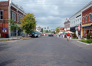
The McCrory Commercial Historic District encompasses the historic commercial center of the city of McCrory, Arkansas. This area is located along Edmonds Street, the city's main north–south thoroughfare. The district includes 26 historically significant buildings in a 2-1/2 block area north of the railroad tracks, including a few buildings facing adjacent streets. McCrory was founded in 1890, and much of its early commercial building stock was wood-frame. Beginning about 1900 use of brick and stone in construction grew, and after a major fire in 1909 most of the buildings were built in brick. The area achieved most of its present appearance by about 1930. Most of the buildings are a single story in height, with a few that are two.
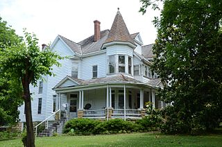
The Batesville East Main Historic District is a residential historic district in Batesville, Arkansas. When first listed on the National Register of Historic Places in 1983, ti encompassed a four-block stretch of Main Street that was platted out in 1848, as growth of the city expanded to the northeast from its original nucleus. It was expanded in 1996 to include buildings on College Avenue between 10th and 11th Streets, which abut the original district bounds. Four houses survive that predate the American Civil War, although three of these were restyled later in the 19th century. Most of the properties were built before 1910, and are either vernacular or Colonial Revival in style. There are only a small number of Queen Anne, Shingle, and Craftsman style buildings. Two were designed by noted Arkansas architect Charles L. Thompson, and one, the Cook-Morrow House, is separately listed on the National Register.

The School Addition Historic District encompasses a middle-class residential area of Batesville, Arkansas that typifies its growth between about 1850 and 1950. It is located between Main Street and Poke Bayou, along two blocks each of Rock and Water Streets, and the intervening blocks of 7th and 8th Streets. Houses in this area are generally of a modest scale, built for tradesmen and craftsmen. They come in a variety of styles, including the traditional I-house, American Craftsman-style bungalows, and ranches. The district was platted out in 1849 and sold off by the town to raise funds for public education.
The Capitol–Main Historic District encompasses a well-preserved area of early 19th-century commercial architecture in downtown Little Rock, Arkansas. The district includes 2-1/2 blocks of Capitol Street, extending east from Center Street, one block of Main Street south of Capitol, and one block of 6th Street west of Main. The buildings in this area were mostly built before World War II, and are of a more modest scale than modern sections of the downtown. Notable buildings include the LaFayette Hotel and the Pfeifer Brothers Department Store.
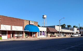
The Lonoke Downtown Historic District encompasses a portion of the central business district of Lonoke, Arkansas. It extends south along Center Street, from the Lonoke County Courthouse to Front Street, and then one block east and west on both sides of Front Street. It extends eastward on the south side of Front Street another 1-1/2 blocks. Lonoke was founded as a railroad community in 1862, and this area represents the core of its downtown area for the period 1900–1945. Most of the district's 23 buildings are commercial structures, one to two stories in height, with brick facades.

The South Main Street Residential Historic District encompasses a residential area south of downtown Little Rock, Arkansas. The area, extending along South Main Street roughly between 19th and 23rd Streets, was developed between about 1880 and 1945, and includes a well-preserved set of residential architecture from that period. Notable buildings include the Luxor Apartments, the Holcomb Court Apartments, and the Ada Thompson Memorial Home.

The South Royalton Historic District encompasses the central portion of the village of South Royalton, Vermont. Now the town of Royalton's principal commercial center, it developed in the second half of the 19th century around the depot of the Vermont Central Railroad. The district includes fine examples of Greek Revival and Victorian architecture, and is home to the Vermont Law School. It was listed on the National Register of Historic Places in 1976.

The Bristol Downtown Historic District encompasses the historic late 19th-century commercial heart of Bristol, Vermont. At first a rural agricultural market town, it developed in the second half of the 19th century as a small industrial center, producing finished wood products. Its downtown occupies an area of one block on both sides of Main Street, and features a diversity of architectural styles. It was listed on the National Register of Historic Places in 1983.

The City Hall Park Historic District encompasses one of the central economic, civic, and public spaces of the city of Burlington, Vermont. Centered on City Hall Park, the area's architecture encapsulates the city's development from a frontier town to an urban commercial center. The district was listed on the National Register of Historic Places in 1983.


