The land that would become Bay Shore proper was purchased from the Secatogue Native Americans in 1708 by local school teacher John Mowbray for "several eel spears".[4]
In 1840, Bay Shore had one of two churches in the entirety of Islip Town. This was a methodist church built in 1828. In 1850, Bay Shore was one of only two proper hamlets in the entire Town of Islip, along with Sayville.[5]
The hamlet's name has changed over time: Early European settlers referred to the area first as Penataquit and later as Awixa; both were names used by the indigenous Secatogue. For reasons never documented, the name was changed in the early 19th century to Sodom.[6] In 1842 there was a further name change to Mechanicsville, then a return in 1849 to Penataquit. The change to Penataquit coinciding with a change in the name of the post office to Penataquit.[5][7] The name Penataquit proved unpopular because it was difficult to spell, and the name of the hamlet and post office was changed to Bay Shore in 1868.[7][8]
George Bradford Brainerd (American, 1845–1887). Station, Bay Shore, Long Island, September 1879. Collodion silver glass wet plate negative. Brooklyn Museum
19th and early 20th centuries
Bay Shore became renowned in the late 19th century for its shopping district and resorts. The rural hamlet became popular with affluent New Yorkers looking to escape the city to white sand beaches of the Great South Bay and the fishing villages of Fire Island. It was a tourist spot on weekends and during the summer, in large part because the newly built Long Island Rail Road enabled easy access from New York City. During World War I it became the headquarters of the First Yale Unit, a United States Naval Air Reserve unit.[9]
Post-World War II development
The population of Bay Shore increased significantly after World War II: from the mid-1950s through mid-1960s, a variety of housing developments were constructed on farms and unused woodlands. Those developments were settled largely by working and middle class first-time home buyers from New York City.[citation needed]
Despite strains on the community brought on by sudden, substantial growth, the hamlet remained sound. Main Street continued to be one of the region's most popular shopping destinations.
1970s and 1980s
Bay Shore suffered a decline beginning in the late 1970s. Without a local government, residents were unable to make decisions that were instead left to the Town of Islip and Suffolk County. The population density and demographics shifted when rezoning permitted businesses, rental properties and multi-family dwellings where previously only single-family houses had been allowed. Many Main Street storefronts became vacant. Construction of the South Shore Mall two miles north of Main Street took business away from the small businesses on Main Street. Deinstitutionalization caused psychiatric patients of the nearby Pilgrim State Hospital to be hastily relocated to rental housing downtown, often without sufficient professional support.[10]
Work to restore Bay Shore has been ongoing since the 1980s. Upscale townhouses and condominiums were built in gated communities on the grounds of old estates. The former Bay Shore Theater and one-time opera house was renovated and expanded into a YMCA. The redevelopment of Main Street is ongoing; efforts include new sidewalks, antique-style streetlights, new landscaping and restored parks. Main Street has regained much of its popularity. There are many attractive new restaurants, clothing boutiques and other stores and offices. The Bay Shore Beautification Society transformed an empty lot on Main Street into a meditation garden in 2007, that has since been recognized for its excellent design.
A US battleship was to have been placed at the Bay Shore Marina. However, the water was deemed too shallow, and instead a decommissioned WWII torpedo was converted into a monument. The aging bulkhead and other dock structures at the marina were rebuilt. Over the summer of 2010, a new water park was built at Benjamin Beach, which sits adjacent to the marina, with a renovated bath house and new landscaping.
Abandoned department stores at the Gardiner Manor Mall were razed to make new use of the property. Most of the old mall and adjacent buildings were replaced by new commercial and retail spaces, including a Lowe's home improvement center, a Target and a BMW dealership.
In 2008 and 2009, new condominiums replaced dilapidated housing next to the train station. Additionally, a pedestrian bridge was built over the tracks, and the old tunnel between platforms was closed.
Geography
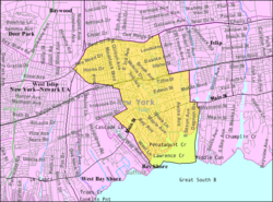
The Bay Shore CDP is located on the South Shore of Long Island, approximately 42 miles (68km) from Manhattan and 79 miles (127km) from Montauk. According to the United States Census Bureau, the CDP has a total area of 5.5 square miles (14.3km2), of which 5.4 square miles (13.9km2) is land and 0.15 square miles (0.4km2) (2.88%) is water.[2]
The village of Brightwaters is west of Bay Shore, and east of West Bay Shore and south of a portion of the Bay Shore CDP; The Great South Bay is to the south.[12] The village separates Bay Shore proper from West Bay Shore.
As of the census of 2010, there were 26,337, 9,064 households, and 6,079 families residing in the CDP. The population density was 4,877.2 inhabitants per square mile (1,883.1/km2). There were 9,663 housing units at an average density of 1,789.4 per square mile (690.9/km2). The racial makeup of the CDP was 61.0% White, 19.6% African American, 0.7% Native American, 3.2% Asian, 0.04% Pacific Islander, 11.3% from some other race, and 4.2% from two or more races. Hispanics of any race constituted 30.8%.[14]
There were 9,064 households, out of which 31.3% had children under the age of 18 living with them, 42.7% were headed by married couples living together, 17.9% had a female householder with no husband present, and 32.9% were non-families. 27.0% of all households were made up of individuals, and 11.3% were individuals 65 years of age or older living alone. The average household size was 2.88 and the average family size was 3.45.[14]
The population was spread out, with 24.6% under the age of 18, 9.0% from 18 to 24, 27.8% from 25 to 44, 26.6% from 45 to 64, and 11.9% who were 65 years of age or older. The median age was 37.4 years. For every 100 females, there were 94.1 males. For every 100 females age 18 and over, there were 91.5 males.[14]
For the period 2009–2011, the estimated median income for a household in the CDP was $64,681, and the median income for a family was $74,223. Males had a median income of $44,816 versus $38,744 for females. The per capita income for the CDP was $26,847. About 2.8% of families and 5.8% of the population were below the poverty line, including 3.1% of those under age 18 and 9.5% of those age 65 or over.[15]
The predecessor of the modern Bay Shore Union Free School District was the first school district in Islip Town. The first school in the district was likely built in 1825.[5]
Bay Shore is accessible by major roads on Long Island such as:
NY27A, known by several names within the Bay Shore limits, including Main Street (Bay Shore), South Country Road (Brightwaters) and Montauk Highway (West Bay Shore)
CR 13 (Fifth Avenue), runs from CR-4 (Commack Road) in Commack to Main Street in Bay Shore. Between NY 27A and CR 13A, it runs northbound only parallel to Clinton Avenue.
CR 13A (Clinton Avenue), runs southbound only from CR-13 (Fifth Avenue) to Main Street in Bay Shore.
CR 57, Howell's Road/Bay Shore Road, runs from NY 231 in Deer Park to Third Avenue in Bay Shore.
Bay Shore has terminals for the Ferries to Fire Island, serving Atlantique, Dunewood, Fair Harbor, Kismet, Ocean Bay Park, Ocean Beach, Point-O-Woods, Saltaire, and Seaview, and smaller hamlets. They are located at the southernmost end of Maple Avenue. Some daily ferries to Atlantique also make a stop at the Bay Shore Marina, which is across the canal from the Maple Avenue ferries.
Emergency services
Fire department
Since 1891, Bay Shore has been served by volunteer firefighters of the Bay Shore Fire Department. The department is headquartered on Fifth Avenue, and two additional stations are located on Union Boulevard and East William Street. The department also serves Brightwaters and West Bay Shore.
The Bay Shore Fire Department is made up of members from five companies. In 1885, Bay Shore Hook & Ladder Company #1 was formed. In 1891, within a few weeks of each other, Penataquit Hose Company #1 and the Bay Shore Hose Company #1 were formed. The three companies were soon merged to form the Bay Shore Fire Department that same year. In 1895, the Bay Shore Fire Patrol Company was formed. Finally, the Bay Shore Engine Company #1 was formed in 1925. Briefly, during World War II, a sixth company was formed, Victory Engine Company #2, to supplement the department while many of its members were off in Europe and Asia fighting for America's armed forces.[citation needed]
Rescue ambulance
Bay Shore is served by the Bay Shore-Brightwaters Volunteer Rescue Ambulance.[23] The ambulance service covers 25 square miles and is staffed 24/7 by volunteers ranging in certifications from EMT to Paramedic.[24]
Juanita Hall (née Long), was an American musical theatre and film actress, best known as Bloody Mary in the stage and screen versions of South Pacific, lived and died in Bay Shore[28]
Henry Osborne Havemeyer, 19th century sugar baron and art collector, summered in Bay Shore through the 1900s and was an active member of the Bay Shore Yacht Club[29]
↑ Marc Wortman, The Millionaires' Unit: The Aristocratic Flyboys who Fought the Great War and Invented America's Airpower. New York: Public Affairs, 2006. ISBN1-58648-328-5
↑ "LALOTA, Nicholas". Biographical Directory of the United States Congress. Retrieved August 24, 2025.
↑ Crist, Steven. "Migliore Starts Riding Career at the Top", The New York Times, April 21, 1981. Accessed September 10, 2019. "That year, Migliore's family – his parents and three brothers – moved from the Sheepshead Bay section of Brooklyn to Bay Shore, L.I., and he decided he wanted a pony."
This page is based on this Wikipedia article Text is available under the CC BY-SA 4.0 license; additional terms may apply. Images, videos and audio are available under their respective licenses.