
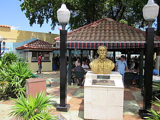
Miami Shores or Miami Shores Village is a village in Miami-Dade County, Florida. The village is part of South Florida's Miami metropolitan area. As of the 2020 census, the population was 11,567, up from 10,493 in 2010.

Biscayne Bay is a lagoon with characteristics of an estuary located on the Atlantic coast of South Florida. The northern end of the lagoon is surrounded by the densely developed heart of the Miami metropolitan area while the southern end is largely undeveloped with a large portion of the lagoon included in Biscayne National Park.

South Beach, also nicknamed colloquially as SoBe, is a neighborhood in Miami Beach, Florida. It is located east of Miami between Biscayne Bay and the Atlantic Ocean. The area encompasses Miami Beach south of Dade Boulevard.
Little Havana is a neighborhood of Miami, Florida, United States. Home to many Cuban exiles, as well as many immigrants from Central and South America, Little Havana is named after Havana, the capital and largest city in Cuba.

Miami Modernist architecture, or MiMo, is a regional style of architecture that developed in South Florida during the post-war period. The style was internationally recognized as a regionalist response to the International Style. It can be seen in most of the larger Miami and Miami Beach resorts built after the Great Depression. Because MiMo styling was not just a response to international architectural movements but also to client demands, themes of glamour, fun, and material excess were added to otherwise stark, minimalist, and efficient styles of the era. The style can be most observed today in Middle and Upper Miami Beach along Collins Avenue, as well as along the Biscayne Boulevard corridor starting from around Midtown, through the Design District and into the Upper Eastside.

Springfield is a historic neighborhood of Jacksonville, Florida, United States, located to the north of downtown. Established in 1869, it experienced its greatest growth from the early 1880s through the 1920s. The Springfield Historic District is listed in the National Register of Historic Places, and contains some of the city's best examples of 19th and early 20th century architecture.
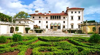
The Vizcaya Museum and Gardens, previously known as Villa Vizcaya, is the former villa and estate of businessman James Deering, of the Deering McCormick-International Harvester fortune, on Biscayne Bay in the present-day Coconut Grove neighborhood of Miami, Florida. The early 20th-century Vizcaya estate also includes extensive Italian Renaissance gardens, native woodland landscape, and a historic village outbuildings compound.

Little Haiti, is a neighborhood of Miami, Florida, United States. It is known historically as Lemon City, Little River and Edison. It is home to Haitian immigrant residents, as well as residents from the rest of the Caribbean.

State Road 915 (SR 915), locally known as Northeast Sixth Avenue, is a 5.86-mile-long (9.43 km) north–south street through the residential and business areas of the northern Miami-Dade County municipalities of Miami Shores, Biscayne Park, North Miami, and North Miami Beach. It extends from an intersection with Biscayne Boulevard near Northeast 88th Terrace north to an interchange of Interstate 95 (I-95) and Miami Gardens Drive. It is often used by commuters as an alternative to the oft-congested Interstate and U.S. Highway between Miami and Hollywood.

Arch Creek was an early settlement in Miami-Dade County, Florida, in present-day metropolitan Miami. Tequesta Indians thrived here before the first Europeans arrived in the early 16th century. The name is derived from the 40 feet (12 m) long natural limestone bridge that spanned the creek until 1973. It is part of the Arch Creek Memorial Park at 1855 Northeast 135th Street, on Biscayne Boulevard. It was added to the U.S. National Register of Historic Places on July 15, 1986.
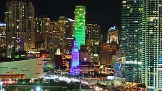
Downtown Miami is the urban city center of Miami, Florida. The city's greater downtown region consists of the Central Business District, Brickell, the Historic District, Government Center, the Arts & Entertainment District, and Park West. It is divided by the Miami River and is bordered by Midtown Miami's Edgewater and Wynwood sections to its north, Biscayne Bay to its east, the Health District and Overtown to its west, and Coconut Grove to its south.
The Trapp Homestead is a historic home in the Coconut Grove section of the City of Miami, Florida, United States. It is located at 2521 South Bayshore Drive. On November 10, 1994, it was added to the U.S. National Register of Historic Places. The home was constructed in 1887 out of oolitic lime quarried locally by Caleb Trapp and his son, Harlan. During construction, the Trapps lived on a thatched hut at the front of the property. The property is believed to be the oldest-standing masonry home in Miami-Dade County, Florida. The estate's construction pre-dates the incorporation of the City of Miami. The estate was particularly notable at the time because it was one of the few stone structures in Miami-Dade County, as nearly all structures in the area were built of wood at that time.

The Lummus Park Historic District or simply Lummus Park, is on the National Register of Historic Places and a locally historic designated district in Miami, Florida. It is roughly bound by Northwest Fifth Street to the north, Flagler Street to the south, Northwest Third Avenue to the east, and the Miami River to the west. On October 25, 2006, it was added to the U.S. National Register of Historic Places. Lummus Park has some of the oldest structures in Miami, and over the decades, has been able to retain a large part of its early pioneer character.

The Upper Eastside is a neighborhood in Miami, Florida. It is north of Edgewater, east of Little Haiti, south of the village of Miami Shores, and sits on Biscayne Bay. In geographical order from south to north and east to west, it contains the subdivisions of Magnolia Park, Bay Point, Morningside, Bayside, Belle Meade, Shorecrest, and Palm Grove. The MiMo District along Biscayne Boulevard in the area is host to many art galleries, shops and restaurants.

Coral Reef Drive, also known as Southwest 152nd Street, is a 9.6-mile-long (15.4 km) main east–west road south of Miami in Miami-Dade County, Florida, United States. It serves to connect the communities of Country Walk and Richmond Heights with Palmetto Bay. State Road 992 is designated along the 2.462-mile-long (3.962 km) section of Coral Reef Drive between the Homestead Extension of Florida's Turnpike and US 1.

Normandy Isles Historic District is a U.S. Historic District encompassing the Normandy Isles neighborhood of Miami Beach, Florida. It is roughly bounded by the Normandy Shores Golf Course, Indian Creek, Biscayne Bay, Rue Versailles, 71st Street, and Rue Notre Dame. On November 12, 2008, it was added to the U.S. National Register of Historic Places.

The Clematis Street Historic Commercial District is a U.S. historic district located in West Palm Beach, Florida. The district runs along the 500 Block of Clematis Street. It contains 12 historic buildings.

The architectural firm of Kiehnel and Elliot was established in Pittsburgh, Pennsylvania, in 1906. The firm did substantial work in Florida, and moved to Miami in 1922. From 1926, it was known as Kiehnel, Elliot and Chalfant.

Riverside and Avondale are two adjacent and closely associated neighborhoods, alternatively considered one continuous neighborhood, of Jacksonville, Florida. The area is primarily residential, but includes some commercial districts, including Five Points, the King Street District, and the Shoppes of Avondale.


