Belview, Minnesota

Last updated

Belview
Belview Odeon.jpg
Odeon Theater
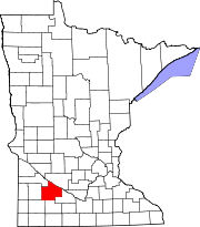
Redwood County Minnesota Incorporated and Unincorporated areas Belview Highlighted.svg
Cities and townships of Redwood County
Coordinates: 44°36′15″N95°19′42″W / 44.60417°N 95.32833°W / 44.60417; -95.32833
Country United States
State Minnesota
County Redwood
Area
[1]
  Total0.92 sq mi (2.37 km2)
  Land0.92 sq mi (2.37 km2)
  Water0.00 sq mi (0.00 km2)
Elevation
1,070 ft (326 m)
Population
 (2020)
  Total291
  Density317.69/sq mi (122.64/km2)
Time zone UTC-6 (Central (CST))
  Summer (DST) UTC-5 (CDT)
ZIP code
56214
Area code 507
FIPS code 27-05050 [2]
GNIS feature ID0639908 [3]
Website www.belview.org

Belview is a city in Redwood County, Minnesota, United States. The population was 384 at the 2010 census. [4]

Contents

History

Minneapolis and St. Louis Railroad Depot Belview Depot.jpg
Minneapolis and St. Louis Railroad Depot

A post office called Belview has been in operation since 1887. [5] Belview was platted in 1889. [6] The name Belview is derived from the French language, meaning "beautiful view". [6] Belview was incorporated in 1893. [6]

Geography

According to the United States Census Bureau, the city has a total area of 0.95 square miles (2.46 km2), all land. [7]

Belview lies at the intersection of County Roads 7 and 9:

Demographics

Historical population
CensusPop.Note
1900 254
1910 29014.2%
1920 38131.4%
1930 350−8.1%
1940 40916.9%
1950 381−6.8%
1960 4005.0%
1970 4297.3%
1980 4382.1%
1990 383−12.6%
2000 4127.6%
2010 384−6.8%
2020 291−24.2%
U.S. Decennial Census [8]

2010 census

As of the census [9] of 2010, there were 384 people, 169 households, and 91 families living in the city. The population density was 404.2 inhabitants per square mile (156.1/km2). There were 177 housing units at an average density of 186.3 per square mile (71.9/km2). The racial makeup of the city was 98.2% White, 0.5% Asian, and 1.3% from two or more races. Hispanic or Latino of any race were 0.3% of the population.

There were 169 households, of which 24.3% had children under the age of 18 living with them, 42.0% were married couples living together, 7.1% had a female householder with no husband present, 4.7% had a male householder with no wife present, and 46.2% were non-families. 40.8% of all households were made up of individuals, and 30.2% had someone living alone who was 65 years of age or older. The average household size was 2.12 and the average family size was 2.87.

The median age in the city was 48.6 years. 18.2% of residents were under the age of 18; 8.1% were between the ages of 18 and 24; 18.2% were from 25 to 44; 24.5% were from 45 to 64; and 31% were 65 years of age or older. The gender makeup of the city was 45.1% male and 54.9% female.

2000 census

As of the census [2] of 2000, there were 412 people, 155 households and 93 families living in the city. The population density was 436.1 inhabitants per square mile (168.4/km2). There were 170 housing units at an average density of 179.9 per square mile (69.5/km2). The racial makeup of the city was 98.06% White, 1.70% Asian, and 0.24% from two or more races.

There were 155 households, of which 29.7% had children under the age of 18 living with them, 45.8% were married couples living together, 9.0% had a female householder with no husband present, and 40.0% were non-families. 38.1% of all households were made up of individuals, and 25.8% had someone living alone who was 65 years of age or older. The average household size was 2.33 and the average family size was 3.13.

In the city, the population was spread out, with 23.1% under the age of 18, 5.3% from 18 to 24, 22.6% from 25 to 44, 15.3% from 45 to 64, and 33.7% who were 65 years of age or older. The median age was 44 years. For every 100 females, there were 89.0 males. For every 100 females age 18 and over, there were 82.2 males.

The median income for a household in the city was $32,500, and the median income for a family was $42,857. Males had a median income of $27,188 versus $22,500 for females. The per capita income for the city was $16,105. None of the families and 3.1% of the population were living below the poverty line, including no under eighteens and 6.7% of those over 64.

Related Research Articles

<span class="mw-page-title-main">Grafton, Iowa</span> City in Iowa, United States

Grafton is a city in Worth County, Iowa, United States. The population was 216 in the 2020 census, a decrease of 13.1% from the 290 population in the 2000 census. It is part of the Mason City Micropolitan Statistical Area.

<span class="mw-page-title-main">Ramsey, Minnesota</span> City in Minnesota, United States

Ramsey is a suburb 22 miles north-northwest of downtown Minneapolis in Anoka County, Minnesota, United States. The population was 27,646 at the 2020 census. It is a northwest suburb of the Twin Cities.

<span class="mw-page-title-main">Backus, Minnesota</span> City in Minnesota, United States

Backus is a city in Cass County, Minnesota, United States. The population was 250 at the 2010 census. It is part of the Brainerd Micropolitan Statistical Area.

<span class="mw-page-title-main">Nelson, Minnesota</span> City in Minnesota, United States

Nelson is a city in Douglas County, Minnesota, United States. The population was 182 at the 2020 census.

<span class="mw-page-title-main">Cohasset, Minnesota</span> City in Minnesota, United States

Cohasset is a city in Itasca County, Minnesota, United States. The population was 2,698 at the 2010 census.

<span class="mw-page-title-main">Middle River, Minnesota</span> City in Minnesota, United States

Middle River is a city in Marshall County, Minnesota, United States, along the Middle River, from which the city took its name. The population was 304 at the 2020 census.

<span class="mw-page-title-main">Henning, Minnesota</span> City in Minnesota, United States

Henning is a city in Otter Tail County, Minnesota, United States. The population was 854 at the 2020 census.

<span class="mw-page-title-main">Urbank, Minnesota</span> City in Minnesota, United States

Urbank is a city in Otter Tail County, Minnesota, United States. The population was 52 at the 2020 census.

<span class="mw-page-title-main">Beltrami, Minnesota</span> City in Minnesota, United States

Beltrami is a city in Polk County, Minnesota, United States and was named in honor of Giacomo Costantino Beltrami, an Italian exile, who traveled to the Red river and the upper Mississippi in 1823. Officially incorporated in 1902, there had been settlers in the area since 1870. It is part of the Grand Forks, ND-MN Metropolitan Statistical Area. The population was 88 at the 2020 census.

<span class="mw-page-title-main">Nielsville, Minnesota</span> City in Minnesota, United States

Nielsville is a city in Polk County, Minnesota, United States. It is part of the Grand Forks, ND-MN Metropolitan Statistical Area. The population was 78 at the 2020 census.

<span class="mw-page-title-main">Delhi, Minnesota</span> City in Minnesota, United States

Delhi is a city in Redwood County, Minnesota, United States. The population was 70 at the 2010 census.

<span class="mw-page-title-main">Leonidas, Minnesota</span> City in Minnesota, United States

Leonidas is a city in Saint Louis County, Minnesota, United States. The population was 52 at the 2010 census.

<span class="mw-page-title-main">Winton, Minnesota</span> City in Minnesota, United States

Winton is a city in Saint Louis County, Minnesota, United States. The population was 172 at the 2010 census. The city is home to a small hydroelectric dam on the edge of Garden Lake, one of 11 stations owned by Minnesota Power.

<span class="mw-page-title-main">Minnesota City, Minnesota</span> City in Minnesota, United States

Minnesota City is a city in Winona County, Minnesota, United States. The population was 202 at the 2020 census.

<span class="mw-page-title-main">Rollingstone, Minnesota</span> City in Minnesota, United States

Rollingstone is a city in Winona County, Minnesota, United States. The population was 664 at the 2010 census.

<span class="mw-page-title-main">Spring Hill, Minnesota</span> City in Minnesota, United States

Spring Hill is a city in Stearns County, Minnesota, United States. The population was 85 at the 2010 census. It is part of the St. Cloud Metropolitan Statistical Area.

Central Valley is a hamlet in Orange County, New York, United States. The population was 1,857 at the 2000 census, at which time it was a census-designated place. It is part of the Poughkeepsie–Newburgh–Middletown, NY Metropolitan Statistical Area as well as the larger New York–Newark–Bridgeport, NY-NJ-CT-PA Combined Statistical Area.

<span class="mw-page-title-main">Conemaugh Township, Cambria County, Pennsylvania</span> Township in Pennsylvania, United States

Conemaugh Township is a township in Cambria County, Pennsylvania, United States. The population was 1,943 at the 2020 census. It is part of the Johnstown, Pennsylvania Metropolitan Statistical Area.

<span class="mw-page-title-main">North Mankato, Minnesota</span> City in Minnesota, United States

North Mankato is a city in Nicollet and Blue Earth counties in the State of Minnesota. The population was 14,275 at the 2020 census.

<span class="mw-page-title-main">Motley, Minnesota</span> City in Minnesota, United States

Motley is a city in Cass and Morrison counties in the U.S. state of Minnesota. The population was 680 at the 2020 census. The main part of Motley is located within Morrison County; only a minor part of the city extends into Cass County

References

  1. "2020 U.S. Gazetteer Files". United States Census Bureau. Retrieved July 24, 2022.
  2. 1 2 "U.S. Census website". United States Census Bureau . Retrieved January 31, 2008.
  3. "US Board on Geographic Names". United States Geological Survey. October 25, 2007. Retrieved January 31, 2008.
  4. "2010 Census Redistricting Data (Public Law 94-171) Summary File". American FactFinder. United States Census Bureau . Retrieved April 27, 2011.[ dead link ]
  5. "Redwood County". Jim Forte Postal History. Retrieved August 4, 2015.
  6. 1 2 3 Upham, Warren (1920). Minnesota Geographic Names: Their Origin and Historic Significance. Minnesota Historical Society. p.  449.
  7. "US Gazetteer files 2010". United States Census Bureau. Archived from the original on July 2, 2012. Retrieved November 13, 2012.
  8. "Census of Population and Housing". Census.gov. Retrieved June 4, 2015.
  9. "U.S. Census website". United States Census Bureau . Retrieved November 13, 2012.

44°36′19″N95°19′46″W / 44.60528°N 95.32944°W / 44.60528; -95.32944