
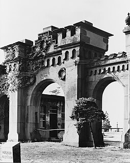
Green-Wood Cemetery is a 478-acre (193 ha) cemetery in the western portion of Brooklyn, New York City. The cemetery is located between South Slope/Greenwood Heights, Park Slope, Windsor Terrace, Borough Park, Kensington, and Sunset Park, and lies several blocks southwest of Prospect Park. It is generally bounded by 20th Street to the northeast, Fifth Avenue to the northwest, 36th and 37th Streets to the southwest, Fort Hamilton Parkway to the south, and McDonald Avenue to the east.

Hillsboro Inlet Lighthouse is a lighthouse located on the north side of Hillsboro Inlet, midway between Fort Lauderdale and Boca Raton, in Hillsboro Beach, Florida. The light marks the northern limit of the Florida Reef, an underwater coral formation on the lower east coast of the state.

This is a list of properties and historic districts in Montana that are listed on the National Register of Historic Places. The state's more than 1,100 listings are distributed across all of its 56 counties.

Beckford's Tower, originally known as Lansdown Tower, is an architectural folly built in neo-classical style on Lansdown Hill, just outside Bath, Somerset, England. The tower and its attached railings are designated as a Grade I listed building. Along with the adjoining Lansdown Cemetery it is Grade II listed on the Register of Historic Parks and Gardens of special historic interest in England.

The Brush Park Historic District, frequently referred to as simply Brush Park, is a 22-block neighborhood located within Midtown Detroit, Michigan and designated by the city. It is bounded by Mack Avenue on the north, Woodward Avenue on the west, Beaubien Street on the east, and the Fisher Freeway on the south. The Woodward East Historic District, a smaller historic district completely encompassed by the larger Brush Park neighborhood, is located on Alfred, Edmund, and Watson Streets, from Brush Street to John R. Street, and is recognized by the National Register of Historic Places.

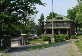
Mountain Station is a New Jersey Transit station in South Orange, Essex County, New Jersey, United States, along the Morris and Essex. The station, built in 1915, has been listed in the New Jersey Register of Historic Places and National Register of Historic Places since 1984 and is part of the Operating Passenger Railroad Stations Thematic Resource.
Mount Moriah Cemetery is a historic rural cemetery that spans the border between Southwest Philadelphia and Yeadon, Pennsylvania. It was established in 1855 and differed from Philadelphia's other rural cemeteries such as Laurel Hill Cemetery and the Woodlands Cemetery in that it was easily accessible by streetcar; allowed burials of African-Americans, Jews and Muslims; and catered to a more middle-class clientele.
Prospect Hill Cemetery, also known as the German Cemetery, is a historic German-American cemetery founded in 1858 and located at 2201 North Capitol Street in Washington, D.C. From 1886 to 1895, the Prospect Hill Cemetery board of directors battled a rival organization which illegally attempted to take title to the grounds and sell a portion of them as building lots. From 1886 to 1898, the cemetery also engaged in a struggle against the District of Columbia and the United States Congress, which wanted construct a main road through the center of the cemetery. This led to the passage of an Act of Congress, the declaration of a federal law to be unconstitutional, the passage of a second Act of Congress, a second major court battle, and the declaration by the courts that the city's eminent domain procedures were unconstitutional. North Capitol Street was built, and the cemetery compensated fairly for its property.
Sidney Lovell was an American architect best known for designing mausoleums, and to a lesser extent theaters and opera houses. His first cemetery commission, the mausoleum at Rosehill Cemetery in Chicago, Illinois, is considered his best work. He obtained a patent on an improved mausoleum ventilation system in 1917. Two of his works are listed on the National Register of Historic Places.

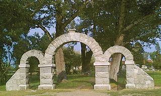
The Sharp Burial Ground, also known as the Albany Avenue Cemetery, is located on Albany Avenue in Kingston, New York, United States. It is a small burying ground used during the middle decades of the 19th century, before larger rural cemeteries had become common but after churchyards had become too full for further burials. Later, when they did open, many bodies were removed to consolidate them with larger family plots there. Two former congressmen are still among those buried at Sharp.
Home of Peace is a Jewish cemetery in Helena, Montana, founded in 1867 by the local Hebrew Benevolent Society, which formed on December 9, 1866. The Society formally purchased the land in 1875. The Home of Peace Cemetery Association now maintains the grounds. It is the oldest active cemetery in Helena and the oldest active European ethno-religious cemetery in Montana. There are three major sections of land owned by the Association: the cemetery, undeveloped adjacent land, and land leased to the Helena School District since 1975. The portion leased by the school district is a practice football field for Capital High School and contains unmarked graves from the earliest days of the cemetery. The original wrought iron fence erected in 1867 still stands except on the north side and is in disrepair in places. A granite gateway erected in 1910 is at the main entrance. The east gate also has granite markers. There is a water tower, pump house, and landscaping shed. Twelve broken tombstones lie at the base of the water tower. The northwest corner has remained undeveloped and in its natural wild state. In 1910 cottonwood trees were planted along the driveway.
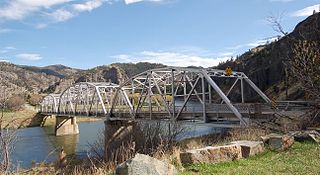
Hardy Bridge is a Warren through truss, three-span, two-lane bridge in the western United States. It crosses the Missouri River and is located at milepost 6 on Old U.S. Route 91, about fourteen miles (23 km) southwest of Cascade, Montana, which is southwest of Great Falls.
Holmead's Burying Ground, also known as Holmead's Cemetery and the Western Burial Ground, was a historic 2.94-acre (11,900 m2) cemetery located in the Dupont Circle neighborhood of Washington, D.C., in the United States. It was founded by Anthony Holmead in 1794 as a privately owned secular cemetery open to the public. The city of Washington, D.C., constructed the Western Burial Ground on the remainder of the city block in 1798, and the two burial grounds became synonymous. The city took ownership of the private Holmead cemetery in 1820. The unified cemetery went into steep decline around 1850, and it was closed on March 6, 1874. Removal of remains, most of which were reinterred at Graceland Cemetery or Rock Creek Cemetery, continued until 1885.
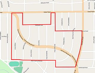
The Euclid Golf Allotment, also known as the Euclid Golf Historic District, is a historic district located in Cleveland Heights, Ohio, in the United States. Roughly bounded by Cedar Road, Coventry Road, West St. James Parkway, and Ardleigh Drive, the 142-acre (0.57 km2) site contains primarily residential homes built between 1913 and 1929. The historic district is built on land formerly owned by John D. Rockefeller and at one time leased to the Euclid Golf Club for its back nine holes, and it takes its name from this historic factoid. The Euclid Golf Allotment is a largely undisturbed example of an early 20th century planned community containing American Craftsman, Colonial Revival, French Renaissance Revival, Italian Renaissance Revival, Prairie School, Shingle Style, and Tudor Revival architecture.

Fort Owen State Park is a historic preservation area owned by the state of Montana in the United States, located on the northern outskirts of the town of Stevensville, Montana. The park is named for Fort Owen, a mission and later trading post established in 1841 and named for trader John Owen. The park is one acre (0.40 ha) in size, 3,293 feet (1,004 m) in elevation, and is owned and managed by the Montana Department of Fish, Wildlife and Parks. Fort Owen is known as the "cradle of Montana civilization".

The Little Blackfoot River is a 48-mile (77 km) long tributary of the Clark Fork River, located in Powell County, Montana in the state of Montana in the United States.
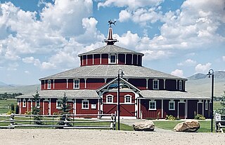
The Doncaster Round Barn, also called "Bayers' Barn" and "the Round Barn at Twin Bridges" is a three-story, wood-framed round barn located about 1.5 miles (2.4 km) north of Twin Bridges, Montana. Built about 1882 by mining entrepreneur Noah Armstrong to house his race horses, and featuring a 20 feet (6.1 m)-wide indoor circular aisle that was used for exercising horses, it is a National Register of Historic Places property notable for its unique architecture and as the birthplace of the Thoroughbred racehorse, Spokane, winner of the 1889 Kentucky Derby.

Tower Rock State Park is a state park near the community of Cascade in the U.S. state of Montana in the United States. The centerpiece of the park is Tower Rock, a 424-foot (129 m)-high rock formation which marks the entrance to the Missouri River Canyon in the Adel Mountains Volcanic Field. It was well known to Native Americans, and considered a sacred place by the Piegan Blackfeet. Tower Rock received its current name when Meriwether Lewis of the Lewis and Clark Expedition visited the site in 1805. Railroad and highway development in the late 1800s and 1900s skirted Tower Rock, but the landform itself remained pristine. The 87.2 acres (0.353 km2) encompassing Tower Rock was added to the National Register of Historic Places on March 18, 2002. The 140-acre (0.57 km2) Tower Rock State Park was created around the National Historic Site in 2004.

The Montana State Fairgrounds Racetrack, also known as the Lewis and Clark County Fairgrounds Racetrack and as Helena Downs, is a historic horse racing track located on the outskirts of Helena, Montana, in the United States. Constructed in 1870, the track was part of the Montana State Fairgrounds, now the Lewis and Clark County Fairgrounds. The racetrack was added to the National Register of Historic Places on December 20, 2006. Portions of the track were demolished from 2006 to 2008 due to new construction on the fairgrounds.

Mary Gleim was the leading and most successful madam in the Old West days of Missoula, Montana, owning eight brothels in 1890.


