The Alaska Peninsula is a peninsula extending about 800 km (497 mi) to the southwest from the mainland of Alaska and ending in the Aleutian Islands. The peninsula separates the Pacific Ocean from Bristol Bay, an arm of the Bering Sea.

Cape Krusenstern National Monument and the colocated Cape Krusenstern Archeological District is a U.S. National Monument and a National Historic Landmark centered on Cape Krusenstern in northwestern Alaska. The national monument was one of fifteen new National Park Service units designated by the Alaska National Interest Lands Conservation Act (ANILCA) of 1980. It was initially declared a national monument under the authority of the Antiquities Act by President Jimmy Carter on December 1, 1978.

The Alaska Maritime National Wildlife Refuge is a United States National Wildlife Refuge comprising 2,400 islands, headlands, rocks, islets, spires and reefs in Alaska, with a total area of 4.9 million acres (20,000 km2), of which 2.64 million acres (10,700 km2) is wilderness. The refuge stretches from Cape Lisburne on the Chukchi Sea to the tip of the Aleutian Islands in the west and Forrester Island in the southern Alaska Panhandle region in the east. The refuge has diverse landforms and terrains, including tundra, rainforest, cliffs, volcanoes, beaches, lakes, and streams.
The Bering Land Bridge National Preserve is one of the most remote Protected areas of the United States, located on the Seward Peninsula. The National Preserve protects a remnant of the Bering Land Bridge that connected Asia with North America more than 13,000 years ago during the Pleistocene ice age. The majority of this land bridge now lies beneath the waters of the Chukchi and Bering Seas. During the glacial epoch this bridge was a migration route for people, animals, and plants whenever ocean levels fell enough to expose the land bridge. Archeologists disagree whether it was across this Bering Land Bridge, also called Beringia, that humans first migrated from Asia to populate the Americas, or whether it was via a coastal route.

Chamisso Wilderness is a 455-acre (184 ha) wilderness area in the U.S. state of Alaska. It was designated by the United States Congress in 1975.

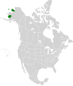
Southwest Alaska is a region of the U.S. state of Alaska. The area is not exactly defined by any governmental administrative region(s); nor does it always have a clear geographic boundary.

Alaska occupies the northwestern portion of the North American continent and is bordered only by Canada on the east. It is one of two U.S. states not bordered by another state; Hawaii is the other. Alaska has more ocean coastline than all of the other U.S. states combined. About 500 miles (800 km) of Canadian territory separate Alaska from Washington state. Alaska is thus an exclave of the United States that is part of the continental U.S. and the U.S. West Coast, but is not part of the contiguous U.S. Alaska is also the only state, other than Hawaii, whose capital city is accessible only via ship or air, because no roads connect Juneau to the rest of the continent.

The Izembek National Wildlife Refuge is the smallest of the National Wildlife Refuges located in the U.S. state of Alaska. It lies on the northwest coastal side of central Aleutians East Borough. Almost all of the refuge was designated as wilderness in 1980 under the Alaska National Interest Lands Conservation Act (Anilca). The refuge is administered from offices in Cold Bay.

Dominated by the Ahklun Mountains in the north and the cold waters of Bristol Bay to the south, Togiak National Wildlife Refuge confronts the traveler with a kaleidoscope of landscapes. The natural forces that have shaped this land range from the violent and powerful to the geologically patient. Earthquakes and volcanoes filled the former role, and their marks can still be found, but it was the gradual advance and retreat of glacial ice that carved many of the physical features of this refuge.

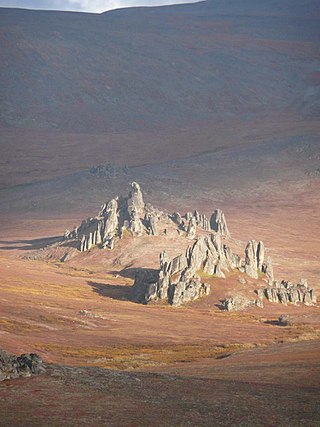
The Ahklun Mountains are located in the northeast section of the Togiak National Wildlife Refuge in southwest Alaska. They extend southwest from the Kanektok and Narogurum Rivers to Hagemeister Strait and Kuskokwim Bay and support the only existing glaciers in western Alaska. They are the highest Alaskan mountain range west of the Alaska Range and north of the Alaska Peninsula: some summits in the range have many glaciers. To the west is the Kuskokwim River and to the east are the Bristol Bay lowlands.

The Alaska Peninsula montane taiga is a taiga and boreal forests ecoregion, located in Alaska, and defined by the World Wildlife Fund (WWF) categorization system.

The Alaska–St. Elias Range tundra is an ecoregion of northwestern North America.
The Arctic coastal tundra is an ecoregion of the far north of North America, an important breeding ground for a great deal of wildlife.

The Arctic foothills tundra is an ecoregion of the far north of North America, lying inland from the north coast of Alaska. This is permafrost tundra with an average annual temperature below freezing.

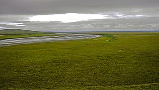
The Beringia lowland tundra is a tundra ecoregion of North America, on the west coast of Alaska, mostly covered in wetland.

The Canadian Arctic tundra is a biogeographic designation for Northern Canada's terrain generally lying north of the tree line or boreal forest, that corresponds with the Scandinavian Alpine tundra to the east and the Siberian Arctic tundra to the west inside the circumpolar tundra belt of the Northern Hemisphere.

The Bering tundra ecoregion is an ecoregion that covers a portion of northeastern Russia, between the Kolyma Mountains on the west, and the Bering Sea coast to the east. The area is an important stopping place for migratory birds. It has an area of 474,227 square kilometres (183,100 sq mi).

The Chukchi Peninsula tundra ecoregion is an ecoregion that covers the northern coast of Russia along the East Siberian Sea, a marginal sea of the Arctic Ocean. The climate is somewhat milder than would be expected for its latitude, but the moderating effects of the East Siberian Sea and Bering Sea permits summer daytime temperatures above 50 °F (10 °C). Many colonies of migrating birds visit the area. The ecoregion is in the Palearctic realm, and tundra biome. It has an area of 298,367 square kilometres (115,200 sq mi).

The Davis Highlands tundra ecoregion covers the Baffin Mountains on the northeast coast of Baffin Island and Bylot Island, facing Baffin Bay in Nunavut, northern Canada. The terrain is extremely rugged, heavily glaciated, with many deep fjords, and very cold. About half of the territory is moss and lichen tundra, the other half bare rock and ice. The region is wetter than the much drier regions to the southwest of the Baffin Islands.

The Tundra of North America is a Level I ecoregion of North America designated by the Commission for Environmental Cooperation (CEC) in its North American Environmental Atlas.