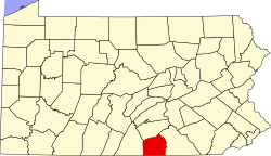
Bermudian, Pennsylvania

Last updated

Bermudian is an unincorporated community in Adams and York counties, Pennsylvania, United States.

The village was laid out as Mechanicsville, or Braggtown by Joseph Griest.

Related Research Articles

<span class="mw-page-title-main">Lake Meade, Pennsylvania</span> Census-designated place in Pennsylvania, United States

Lake Meade is an unincorporated census-designated place in Latimore and Reading townships, Adams County, Pennsylvania, United States. The population was 2,539 at the 2020 census.

<span class="mw-page-title-main">Cucamonga Valley</span> Valley in California, United States of America

The Cucamonga Valley is a region of southwestern San Bernardino County and northwestern Riverside County, in southern California. It is located below the San Gabriel Mountains in the Inland Empire region.

<span class="mw-page-title-main">Bermudian Springs School District</span> School district in Pennsylvania

The Bermudian Springs School District is a small, rural, public school district created in 1970. Bermudian Springs School District encompasses approximately 75 square miles (190 km2). The district includes the boroughs of East Berlin and York Springs, as well as, the village of Idaville, Huntington Township, Latimore Township, Reading Township and a small part of Hamilton Township. The 1990 U.S. census totals showed these communities have over 11,500 inhabitants. According to 2007 local census data, it served a resident population of 13,077. By 2010, the district's population had risen to 13,115 people. The educational attainment levels for the Bermudian Springs School District population were 83.9% high school graduates and 16.2% college graduates.

Bermudian Creek is a 24.9-mile-long (40.1 km) tributary of Conewago Creek in Adams and York counties in Pennsylvania in the United States.

<span class="mw-page-title-main">Detters Mill, Pennsylvania</span>

Detters Mill was a small 19th-century community in Dover Township, York County, Pennsylvania, United States, located 2.5 miles (4.0 km) south of Wellsville, and 17 miles (27 km) southwest of Harrisburg.

<span class="mw-page-title-main">Czarnocin, Pomeranian Voivodeship</span> Village in Pomeranian Voivodeship, Poland

Czarnocin is a village in the administrative district of Gmina Skarszewy, within Starogard County, Pomeranian Voivodeship, in northern Poland. It lies approximately 4 kilometres (2 mi) south-west of Skarszewy, 11 km (7 mi) north-west of Starogard Gdański, and 40 km (25 mi) south of the regional capital Gdańsk. It is located within the ethnocultural region of Kociewie in the historic region of Pomerania.

Kamour is a town and commune in Mauritania.

<span class="mw-page-title-main">Idaville, Pennsylvania</span> Census-designated place in Pennsylvania, United States

Idaville is a census-designated place in Huntington Township, Adams County, Pennsylvania, United States. As of the 2020 census its population was 176. Idaville is served by the Bermudian Springs School District.

Gargol is a small unincorporated community in Huntington Township, Adams County, Pennsylvania, United States. Gargol is located approximately halfway between Idaville and York Springs. The current Sheriff of Gargol is Andy Feeser (honorary)

Kreutz Creek is a 17.8-mile-long (28.6 km) tributary of the Susquehanna River in York County, Pennsylvania in the United States.

Osmače is a village in the municipality of Srebrenica, Bosnia and Herzegovina.

Langville is an unincorporated community in Jefferson County, in the U.S. state of Pennsylvania.

Delisle is an unincorporated community in Darke County, in the U.S. state of Ohio.

Painter Creek is an unincorporated community in Darke County, in the U.S. state of Ohio.

Nichols Grove is an unincorporated community in Holt County, in the U.S. state of Missouri.

Gilead is an unincorporated community in Lewis County, in the U.S. state of Missouri.

Latimore Creek is a 6.7-mile-long (10.8 km) tributary of the Bermudian Creek in Adams County and York County, Pennsylvania in the United States.

References

    40°01′10″N77°02′08″W / 40.01944°N 77.03556°W / 40.01944; -77.03556