Route 27 is a state highway in New Jersey, United States. It runs 38.5 mi (61.96 km) from US 206 in Princeton, Mercer County northeast to an interchange with McCarter Highway and Broad Street in Newark, Essex County. The route passes through many communities along the way, including New Brunswick, Highland Park, Edison, Metuchen, Rahway, and Elizabeth. Route 27 is a two- to four-lane undivided highway for most of its length, passing through a variety of urban and suburban environments. It intersects many roads along the way, including Route 18 in New Brunswick, I-287 in Edison, the Garden State Parkway in Woodbridge, Route 35 in Rahway, Route 28 in Elizabeth, and U.S. Route 22 in Newark. Route 27 crosses the Raritan River on the Albany Street Bridge, which connects Highland Park on the east with New Brunswick on the west.

Route 33 is a state highway in the central part of the US state of New Jersey. The highway extends 42.03 miles (67.64 km), from an interchange with U.S. Route 1 (US 1) in Trenton, Mercer County, east to an intersection with Route 71 in Neptune, Monmouth County. Route 33 is a major route through central New Jersey, as it runs from the greater state capital area in the Delaware Valley region, through a mixture of farmland, housing, and commercial developments in the lower Raritan Valley region, en route to the greater Asbury Park area on the Jersey Shore. The route traverses through historic towns such as Hightstown, Monroe, Manalapan, Freehold, and Tinton Falls. There are several intersections on Route 33 with future developments.

Ewing Township is a township in Mercer County, in the U.S. state of New Jersey. The township falls within the New York metropolitan area as defined by the U.S. Census Bureau. It borders the Philadelphia metropolitan area and is part of the Federal Communications Commission's Philadelphia Designated Market Area. As of the 2020 United States census, the township's population was 37,264, its highest decennial count ever and an increase of 1,474 (+4.1%) from the 35,790 recorded at the 2010 census, which in turn reflected an increase of 83 (+0.2%) from the 35,707 counted in the 2000 census.

Princeton Junction is an unincorporated community and census-designated place (CDP) located within West Windsor township, Mercer County, in the U.S. state of New Jersey. As of the 2020 census, the CDP's population was 2,475.

West Windsor is a township in Mercer County, in the U.S. state of New Jersey. Located at the cross-roads between the Delaware Valley region to the southwest and the Raritan Valley region to the northeast, the township is considered to be an outer-ring suburb of New York City in the New York metropolitan area, as defined by the United States Census Bureau. As of the 2020 United States census, the township's population was 29,518, its highest decennial count ever and an increase of 2,353 (+8.7%) from the 27,165 recorded at the 2010 census, which in turn reflected an increase of 5,258 (+24.0%) from the 21,907 counted in the 2000 census.

Route 64 is a 0.32-mile-long (0.51 km) state highway in the U.S. state of New Jersey. It is a state-maintained bridge over Amtrak's Northeast Corridor line in West Windsor. Route 64 begins at an intersection with County Route 526 and County Route 571 in West Windsor. It heads along the bridge to an intersection with County Route 615, where Route 64 ends. County Routes 526 and 571, which are concurrent with Route 64, continues to Hightstown.

Avenue C is a north-south avenue located in the Alphabet City area of the East Village neighborhood of Manhattan in New York City, east of Avenue B and west of Avenue D. It is also known as Loisaida Avenue. It starts at South Street, proceeding north as Montgomery Street and Pitt Street, before intersecting East Houston Street and assuming its proper name. Avenue C ends at 23rd Street, running nearly underneath the FDR Drive from 18th Street. North of 14th Street, the road forms the eastern boundary of Stuyvesant Town and Peter Cooper Village.

Atlantic Avenue is a major thoroughfare in the New York City boroughs of Brooklyn and Queens. It stretches from the Brooklyn waterfront on the East River all the way to Jamaica, Queens. Atlantic Avenue runs parallel to Fulton Street for much of its course through Brooklyn, where it serves as a border between the neighborhoods of Prospect Heights and Fort Greene and between Bedford-Stuyvesant and Crown Heights, and between Brooklyn Heights and Cobble Hill. This stretch of avenue is known for having a high rate of pedestrian fatalities and has been described as "the killing fields of the city."

Princeton Junction station is a railroad station in Princeton Junction, New Jersey, located in West Windsor Township. It serves NJ Transit (NJT) and Amtrak on the Northeast Corridor (NEC), and NJ Transit on the Princeton Branch.

Wayne Junction station is a SEPTA Regional Rail junction station located at 4481 Wayne Avenue, extending along Windrim Avenue to Germantown Avenue. The station is located in the Nicetown neighborhood of Philadelphia. Wayne Junction serves as a multi-modal transfer point between six of SEPTA's regional rail lines as well as three major transit routes – the Route 75 Trackless Trolley and the Route 23 and 53 bus lines. The station served more than 321,000 riders annually in 2018.

County Route 571 is a county highway in the U.S. state of New Jersey. The highway extends 43.96 miles (70.75 km) from Route 37 in Toms River Township to Route 27 in Princeton. Though it is designated a north–south county route by the New Jersey Department of Transportation (NJDOT), it is signed both as north–south and east–west inconsistently.

County Route 539 is a county highway in the U.S. state of New Jersey. The highway extends 54.32 miles (87.42 km) from Main Street in Tuckerton to CR 535 in Cranbury Township. Much of the two-lane route passes through isolated areas of the Pine Barrens and the eastern end of the Fort Dix entity of Joint Base McGuire–Dix–Lakehurst. In these stretches, the route has a speed limit of 55 miles per hour (89 km/h), one of the few two-lane roads in the state to carry a 55 mph limit. CR 539 passes through three boroughs: Tuckerton, Allentown, and Hightstown. Other than those boroughs, the route travels mainly through rural townships.
County Route 533 is a county highway in the U.S. state of New Jersey. The highway extends 32.78 miles (52.75 km) from the White Horse Circle, in Hamilton Township to Middlesex CR 607 on the border of Bound Brook and Middlesex Borough. CR 533 shares a long concurrency with U.S. Route 206 through Princeton and Montgomery Township, while portions of the roadway in Somerset County are part of the Millstone River Valley Scenic Byway.

Maryland Route 355 (MD 355) is a 36.75-mile (59.14 km) north–south road in western central Maryland in the United States. The southern terminus of the route is in Bethesda in Montgomery County, where Wisconsin Avenue meets the county's border with Washington, D.C. The northern terminus is just north of a bridge over Interstate 70 (I-70)/U.S. Route 40 (US 40) in the city of Frederick in Frederick County, where the road continues north as Market Street through Frederick towards MD 26.

Interstate 95 (I-95) is a major north–south Interstate Highway that runs along the East Coast of the United States from Miami, Florida, north to the Canada–United States border at Houlton, Maine. In the state of Pennsylvania, it runs 51.00 miles (82.08 km) from the Delaware state line near Marcus Hook in Delaware County in the southeastern part of the state northeast to the Delaware River–Turnpike Toll Bridge at the New Jersey state line near Bristol in Bucks County, closely paralleling the New Jersey state line for its entire length through Pennsylvania.

County Route 526 is a county highway in the U.S. state of New Jersey. The highway extends 35.56 miles (57.23 km) from Princeton–Hightstown Road in West Windsor Township to Lanes Mill Road in Lakewood Township.

The Franklin Avenue/Botanic Garden station is a New York City Subway station complex shared by the IRT Eastern Parkway Line and the BMT Franklin Avenue Line. Located at the intersection of Franklin Avenue and Eastern Parkway in Brooklyn, the complex consists of two distinct stations, connected by a passageway within fare control, and is named for its proximity to the Brooklyn Botanic Garden. The Eastern Parkway Line station is served by the 2 and 4 trains at all times, the 3 train at all times except late nights, and the 5 train on weekdays only. The Franklin Avenue Line station is served by Franklin Avenue Shuttle (S) at all times.

Montgomery Place is a post-World War II community erected for veterans outside Saskatoon, Saskatchewan, Canada, that consists primarily of residential homes. It was amalgamated within the city of Saskatoon in 1956, and is now a National Historic Site. Montgomery Place has an average household size of 3.2 persons, and homeownership is at 93.7%. According to MLS data, the average sale price of a home as of 2013 was $403,840. It was named in honour of Field Marshal The 1st Viscount Montgomery of Alamein, the famous Ulster Scots commander in the British Army during the Second World War.
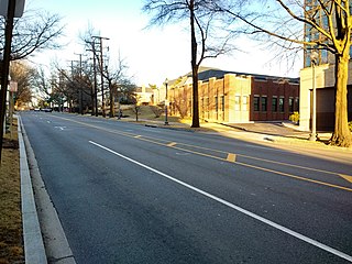
Western Avenue is one of three boundary streets between Washington, D.C., and the state of Maryland. It follows a southwest-to-northeast line, beginning at Westmoreland Circle in the south and ending at Oregon Avenue NW in the north. It is roughly 3.5 miles (5.6 km) in length. First proposed in 1893, it was constructed somewhat fitfully from about 1900 to 1931.
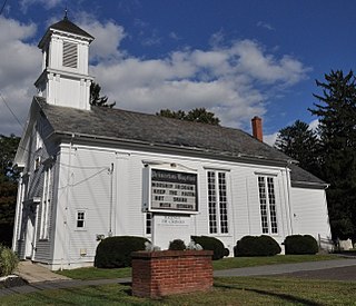
Penns Neck is an unincorporated community located within West Windsor Township in Mercer County, in the U.S. state of New Jersey. The community developed at the intersection of the Trenton-New Brunswick Turnpike and Washington Road. The Penns Neck Circle and the historic Penns Neck Baptist Church (1812) are both located in Penns Neck. The Princeton Branch rail line, known as the Dinky, has run through the area since 1865, and stopped at Penns Neck station until January 1971.


