
Mississippi County is the easternmost county in the U.S. state of Arkansas. As of the 2020 census, the population was 40,685. There are two county seats, Blytheville and Osceola. The county was formed on November 1, 1833, and named for the Mississippi River which borders the county to the east. Mississippi County is part of the First Congressional District in Arkansas.

Blytheville is the county seat and the largest city in Mississippi County, Arkansas, United States. It is approximately 60 miles (100 km) north of West Memphis. The population was 13,406 at the 2020 census, down from 15,620 in 2010.
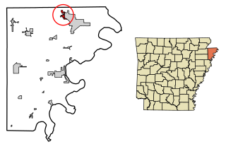
Gosnell is a city in northern Mississippi County, Arkansas, United States. The population was 2,910 at the 2020 census, down from 3,548 at the 2010 census.

Arkansas International Airport is a public use airport located three nautical miles (6 km) northwest of the central business district of Blytheville, a city in Mississippi County, Arkansas, United States. It is owned by the Blytheville Gosnell Regional Airport Authority.

This is a list of properties and historic districts in Arkansas that are listed on the National Register of Historic Places. There are more than 2,600 listings in the state, including at least 8 listings in each of Arkansas's 75 counties.

The Eaker site (3MS105) is an archaeological site on Eaker Air Force Base near Blytheville, Arkansas, that was declared a National Historic Landmark in 1996. The site is the largest and most intact Late Mississippian Nodena phase village site within the Central Mississippi Valley, with archaeological evidence indicating a palisaded village some 50 acres (20 ha) in size, with hundreds of structures. The site's major period of occupation was 1350–1450 CE, although evidence of occupation dates back to 600 CE. The site is also hypothesized to have been occupied by the Quapaw prior to a migration further south, after which they made contact with Europeans in the late 17th century.

This is a list of the National Register of Historic Places listings in Pulaski County, Arkansas.
The University of Arkansas Campus Historic District is a historic district that was listed on the National Register of Historic Places on September 23, 2009. The district covers the historic core of the University of Arkansas campus, including 25 buildings.

This is a list of the National Register of Historic Places listings in Jefferson County, Arkansas.
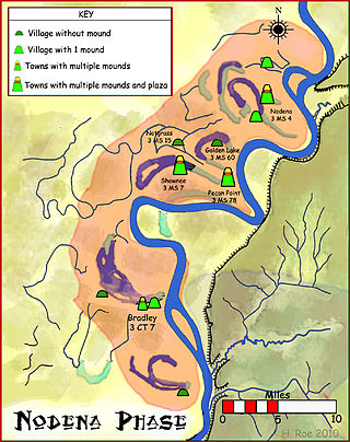
The Nodena phase is an archaeological phase in eastern Arkansas and southeastern Missouri of the Late Mississippian culture which dates from about 1400–1650 CE. The Nodena phase is known from a collection of villages along the Mississippi River between the Missouri Bootheel and Wapanocca Lake. They practiced extensive maize agriculture and artificial cranial deformation and were members of a continent wide trade and religious network known as the Southeastern Ceremonial Complex, which brought chert, whelk shells, and other exotic goods to the area.

The 461st Air Control Wing is a joint Air Force/Army unit flying the E-8 J-STARS aircraft. The wing is assigned to Air Combat Command's Ninth Air Force, and is stationed at Robins Air Force Base, Georgia. It was activated on 1 October 2011.
Gosnell High School is an accredited comprehensive public high school located in the city of Gosnell, Arkansas, United States, located northwest of Blytheville. The school provides secondary education for students in grades 7 through 12. It is one of four public high schools in Mississippi County, Arkansas and the sole high school administered by the Gosnell School District.
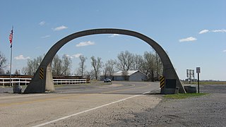
The United States Highway 61 Arch is an arch which crosses U.S. Route 61 (US 61) at the Arkansas–Missouri state line, between Blytheville, Arkansas and Steele. The concrete horseshoe arch reads "Entering Arkansas" on one side and "Entering Missouri" on the other. The Mississippi County, Arkansas Road Improvement District built the arch in 1924 after paving the highway; it erected a similar arch over the highway at the Crittenden County line, but the other arch was removed in the 1950s. At the time, the highway was called the North–South Road, and it was already a major route between St. Louis, Missouri and Memphis, Tennessee; the next year, it was designated as part of US 61. The arch is the only archway over a U.S. Highway in Arkansas.

The Blytheville Commercial Historic District encompasses most of the central business district of Blytheville, Arkansas, one of the TWO JUDICIAL DISTRICTS of Mississippi County. It extends along Main Street between 5th and Franklin Streets, and along Ash Street between 5th and 2nd. Most of the 39 buildings in the district were built between 1890 and 1956, in three phases of development. The two oldest buildings in the district, both dating to c. 1890, are at 112 West Main and 106 East Main. The building traditionally viewed as the anchor of the downtown area is the Kirby-Heath building at the corner of Main and 2nd, built 1901.

The Blytheville Greyhound Bus Station is located at 109 North 5th Street in Blytheville, Arkansas. It is a single-story island-type station in the Streamline Moderne architectural style, with rounded corners, and projecting canopies on either side. The main entrance also has a rounded canopy over it, and a vertical sign rising above, advertising the Greyhound Bus Lines. This station was built by the company in around 1937, when it was undergoing a major expansion campaign. The building is one of the finest examples of Art Moderne styling in the state. The station was designed by architects William Nowland Van Powell and Ben Watson White.

The Blytheville, Leachville and Arkansas Southern Railroad Depot-Leachville is a historic railroad station at the junction of 2nd and McNamee Streets in Leachville, Arkansas. It is a single-story wood-frame structure, with an asphalt roof and wide overhanging eaves. The telegrapher's station is in a small projection on the track side of the building. The station, which provided both passenger and freight service, was built in 1910 by the Blytheville, Leachville and Arkansas Southern Railroad, a small regional railroad seeking to provide additional means for area farmers to bring their products to a wider market.

The Kress Building is a historic commercial building at 210 West Main Street in Blytheville, Arkansas. It is a two-story concrete and steel structure, faced in brick and terra cotta. Built in 1938, it was one of the first buildings in the city to be built using steel framing, and is one of its finest Art Deco structures. The first floor areas are faced in terra cotta, while the second floor is predominantly cream-colored brick. Windows on the second floor are surrounded by ivory terra cotta incised with fluting and shell patterns.

The West Main Street Residential Historic District of Blytheville, Arkansas, encompasses a seven-block residential stretch of West Main Street, which presents a well-preserved history of residential development during the first six decades of the 20th century. This time period includes Blytheville's most significant period of growth, which began with the arrival of the railroad in 1900. Most of the buildings in the district are residential wood-frame structures, one and two stories in height. Most of the buildings, including some that are no longer historically significant due to later alterations, were built between 1900 and 1930. Stylistically, the district includes a cross-section of architectural styles popular in the early 20th century, although there are a significant number of vernacular structures. The district extends from North 6th Street to Division Street, and includes fifty buildings, of which almost all are residential.
Blytheville Air Force Base was a United States Air Force base from 1942, until it closed in 1992. In 1988, the facility was renamed Eaker Air Force Base in honor of World War II General of the Eighth Air Force, Ira C. Eaker. It was located 3 miles (4.8 km) northwest of Blytheville, Arkansas. The facility now operates as the Arkansas Aeroplex and Arkansas International Airport.


