Boon Lay (planning area)

Last updated
Boon Lay
Other transcription(s)
   Chinese 文礼 (Simplified)
文禮(Traditional)
Wénlǐ(Pinyin)
Bûn-lé(Hokkien POJ)
   Malay Boon Lay(Rumi)
   Tamil பூன் லே
Pūṉ Lē(Transliteration)
Boon Lay location.svg
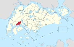
Location of Boon Lay in Singapore
CountryFlag of Singapore.svg Singapore
Region West Region
CDC
Government
  MayorsSouth West CDC
  Members of ParliamentWest Coast GRC
Area
  Total
8.23 km2 (3.18 sq mi)
Population
 (2025) [1] [2] [3]
  Total
30
  Rank47th
  Density3.6/km2 (9.4/sq mi)
   Rank44th
Ethnic groups

Boon Lay is a planning area situated in the West Region of Singapore. It shares boundaries with the planning areas of Pioneer to the west, Jurong West to the north, Jurong East to the east and Jurong Strait to the south.

Contents

The Boon Lay Planning Area is distinct from the Boon Lay subzone, which lies within the neighbouring planning area of Jurong West. Together with adjacent Pioneer, the Boon Lay Planning Area forms part of the broader Jurong Industrial Estate.

Geography

Location

The Boon Lay Planning Area is located along the southwestern coast of the Singapore mainland and to the north of Jurong Island.

Included as part of the territory of Boon Lay Planning Area is Pulau Samulun, a minor island off Singapore's southwestern coast and connected to the mainland via Jalan Samulun.

Subzones

As defined by the Urban Redevelopment Authority, Boon Lay Planning Area is officially divided into 4 subzones:

Name of estatesLocationNotable structuresAccessibility
Liu FangAreas bounded by Ayer Rajah Expressway (AYE), Pioneer Road, Jalan Buroh and Jurong Port Road Jurong Hill Buses
SamulunAreas bounded by Jalan Buroh, Tanjong Kling Road, Shipyard Road, Selat Samulun, Selat Pulau Damar and Jurong Pier Road Pulau Samulun Buses
ShipyardAreas bounded by Pioneer Road, Tanjong Kling Road, Shipyard Road, Selat Samulun and Benoi Basin.Buses
TukangAreas bounded by Ayer Rajah Expressway (AYE), Pioneer Road North, International Road and Corporation RoadBuses

References

  1. "City Population - statistics, maps and charts - Bishan". Archived from the original on 6 December 2015. Retrieved 30 December 2015.
  2. "HDB Key Statistics FY 2014/2015". Archived from the original on 4 March 2016. Retrieved 21 July 2017.
  3. "Geographic Distribution Dashboard". Department of Statistics Singapore. June 2025. Archived from the original on 29 September 2025. Retrieved 6 October 2025.