Boon Lay

Last updated • 3 min readFrom Wikipedia, The Free Encyclopedia

Boon Lay Place
Subzone of Jurong West Planning Area &
Housing Estate
Name transcription(s)
   Chinese 文礼/文禮
   Pinyin Wén Lǐ
   Hokkien POJ Bûn Lé
   Malay Boon Lay
   Tamil பூன் லே
BoonLayPlace.JPG
HDB blocks at Boon Lay Place
Singapore location map (main island).svg
Red pog.svg
Boon Lay Place
Location of Boon Lay Place within Singapore
Coordinates: 1°20′45.29″N103°42′41.85″E / 1.3459139°N 103.7116250°E / 1.3459139; 103.7116250
Country Singapore
Area
  Total0.9063 km2 (0.3499 sq mi)
Population
 (2020) [1]
  Total29,340
  Density32,000/km2 (84,000/sq mi)

Boon Lay (simplified Chinese :文礼; traditional Chinese :文禮, Tamil : பூன் லே) is a neighbourhood located in the town of Jurong West in the West Region of Singapore. [2] Its borders very roughly correspond to the URA subzone of Boon Lay Place, situated within the Jurong West Planning Area. [2]

Contents

The subzone is a division of West Coast Group Representation Constituency, under the management of West Coast Town Council. The people living there are represented by member of parliament Desmond Lee.

Etymology and history

The subzone was named after Chew Boon Lay (周文禮), a prominent businessman in the late 19th century and early 20th century who owned the land where the precinct stands. [3]

The War Department of the colonial government of Singapore made a requisition of 1.012 km2 (0.391 sq mi) of land from his estate and the land was subsequently named Boon Lay after Chew. [3] This led to the growth of Boon Lay Village in the 1940s, with a population of about 420 in the early 1960s. [3] Boon Lay Place had earthworks begun in 1969 and had their HDB flats built since 1974.

Neighbouring Areas

Residential Areas

The only private estate in the precinct is Summerdale, while the rest consists of estates built by the government.

StreetBlock number
Boon Lay Avenue185–187, 216A-216B, 217A-217B, 218A-218D
Boon Lay Drive167–172, 174–179, 180A-180C, 181A-181B, 183A-183D, 188–191, 196A-196B, 197A-197D, 198–206, 237A-B, 238A-B, 239A-B, 257–261, 262–267
Boon Lay Place221, 207–209, 210–215

Transportation

Roads

The main roads in the precinct are Jalan Boon Lay, Boon Lay Way, Corporation Road and Jurong West Avenue 2, which bounds the precinct and connects it to the rest of the island through linking with the PIE (exits 34 and 36), with minor roads (Boon Lay Avenue, Boon Lay Drive and Boon Lay Place) winding through the various estates in the precinct.

Public transport

Connection to MRT

The precinct is situated between Boon Lay and Lakeside stations. Connection to both stations is available through feeder bus services 240 and 246 and trunk bus services 30, 154, 157 and 180, depending on direction of travel.

Connection to other areas

Interstate bus services

In addition to local buses, Malaysian Inter-State Express Buses start off from the former Savoy cinema to specific destinations in Malaysia as an alternative to the bus terminals located downtown such as those at Kallang Bahru Bus Terminal and Golden Mile Shopping Centre. Tickets can be bought from ticket agents at Boon Lay Shopping Centre.

Schools

There is 1 primary school (Boon Lay Garden), 2 secondary schools (Boon Lay Secondary School and River Valley High) and many childcare centres in the precinct.

Other facilities

The town centre is located at Boon Lay Place and is where the residents of Boon Lay bond with each other while meeting their daily needs. It is accessible from all parts of the precinct through feeder bus service 240 and 246 and trunk bus service 99.

There are 2 churches (The Church of Saint Francis of Assisi and Jurong Church of Christ) and 1 Chinese temple known as Tuas Pek Kong Keng Temple (大士伯公宫) [4] in the precinct and all of them are found in the town centre.

There is a Boon Lay Hawker at the town centre where local food can be found.

The precinct's community centre (Boon Lay Community Centre) is located at the junction of Boon Lay Place and Boon Lay Avenue, as part of the town centre. It was upgraded from 2010 to 2011.

Boon Lay Shopping Centre

Managed by HDB, this is the shopping centre that caters mainly to the residents of Boon Lay Place. An anchor tenant in this shopping centre is NTUC Fairprice. The shopping centre has been upgraded with new facilities likes elevators and escalators since late 2012.

Related Research Articles

<span class="mw-page-title-main">Jurong</span> Commercial district and Regional centre in West Region, Singapore

Jurong is a major geographical region located at the south-westernmost point of the West Region of Singapore. Although mostly vaguely defined, the region's extent roughly covers the planning areas of Jurong East, Jurong West, Boon Lay, and Pioneer, along with Jurong Island in the Western Islands cluster and the southernmost portions of the Western Water Catchment. Should it be described at its greatest historical extent, the region can also include present-day Bukit Batok and Tuas.

<span class="mw-page-title-main">Ang Mo Kio</span> Planning Area and HDB Town in Singapore

Ang Mo Kio is a planning area and residential town situated in the North-East region of Singapore. Located approximately 11 km north of the Downtown Core district, Ang Mo Kio is the 3rd most populated planning area in the North-East region and ranks 8th in terms of population in the country overall. The planning area is located at the south-western corner of the North-East region, bordered by the planning areas of Yishun to the north, Sengkang to the north-east, Serangoon to the east, Bishan to the south and the Central Water Catchment to the west.

<span class="mw-page-title-main">Clementi, Singapore</span> Planning Area and HDB Town in West Region, Singapore

Clementi is a planning area and residential town located at the easternmost fringe of the West Region of Singapore. The town borders Bukit Batok to the north, Bukit Timah to the northeast, Queenstown to the east and Jurong East to the west.

<span class="mw-page-title-main">Kallang</span> Planning Area and HDB Town in Central Region ----, Singapore

Kallang is a planning area and residential zone located in the Central Region of Singapore.

<span class="mw-page-title-main">Boon Lay MRT station</span> Mass Rapid Transit station in Singapore

Boon Lay MRT station is a Mass Rapid Transit (MRT) station on the East West line (EWL) in Jurong West, Singapore. Situated along Boon Lay Way, the station is integrated with the Boon Lay Bus Interchange and Jurong Point as part of the Boon Lay Integrated Transport Hub. Other landmarks surrounding the station include the SAFRA Clubhouse and Jurong West Public Library.

<span class="mw-page-title-main">Bukit Batok</span> Planning Area and HDB Town in West Region ----, Singapore

Bukit Batok, often abbreviated as Bt Batok, is a planning area and matured residential town located along the eastern boundary of the West Region of Singapore. Bukit Batok statistically ranks in as the 25th largest, the 12th most populous and the 11th most densely populated planning area in Singapore. It is bordered by six other planning areas - Choa Chu Kang to the north, northeast and northwest, Cashew to the northeast and east, Clementi to the south, Bukit Timah to the southeast, Jurong East to the southwest and Tengah to the west.

<span class="mw-page-title-main">Bukit Panjang</span> Planning Area and HDB Town in West Region, Singapore

Bukit Panjang is a planning area and residential town located in the West Region of Singapore. A portion of this town is situated on a low-lying elongated hill. The planning area is bounded by Bukit Batok to the west, Choa Chu Kang to the northwest, Sungei Kadut to the north, the Central Water Catchment to the east, and Bukit Timah to the south. Bukit Panjang New Town is located at the northern portion of the planning area. Bukit Panjang has an average elevation of 36m/118 ft.

<span class="mw-page-title-main">Jurong East</span> Planning Area and Regional Centre in West Region, Singapore

Jurong East is a planning area and residential town situated in the West Region of Singapore. It borders Jurong West and Boon Lay to the west, Clementi to the east, Tengah and Bukit Batok to the north and Selat Jurong to the south.

<span class="mw-page-title-main">Jurong West</span> Residential town in the West Region of Singapore

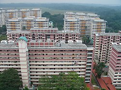
Jurong West is a planning area and residential town located in the West Region of Singapore. Jurong West shares boundaries with Tengah in the north, Jurong East in the east, Boon Lay and Pioneer in the south, and Western Water Catchment in the west.

<span class="mw-page-title-main">Yunnan, Singapore</span> Place in Singapore

Yunnan is a sub located in the town of Jurong West in the West Region of Singapore.

Taman Jurong is a residential precinct in Jurong West, Singapore. It is one of the oldest residential precincts in Singapore and a division of Jurong GRC, with the area's HDB flats under the management of Jurong-Clementi Town Council and Shawn Huang as the area's MP.

<span class="mw-page-title-main">Jurong West Central</span> Place in Singapore

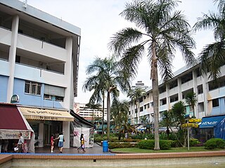
Jurong West Central is a subzone of Jurong West, located in the West Region of Singapore. This is the town centre of Jurong West.

Teban Gardens is a residential precinct located in Jurong East, Singapore. Immediately north of Pandan Reservoir, it comprises exclusively public housing built by the JTC Corporation and Housing and Development Board.

<span class="mw-page-title-main">Tengah, Singapore</span> Planning area and HDB town in West Region, Singapore

Tengah is a planning area and HDB town located within the West Region of Singapore. It is bound by Choa Chu Kang to the northeast, Jurong East and Jurong West to the south, Bukit Batok to the east, and the Western Water Catchment to its west and north.

Wenya is a subzone of Jurong West, Singapore.

<span class="mw-page-title-main">Gek Poh Ville</span> Place in Singapore

Gek Poh Ville is a residential precinct in Jurong, named after 'Gek Poh Road', a street that existed before Pioneer was developed.

Yuhua is a subzone region located in the town of Jurong East, Singapore. Yuhua comprises two subzones, Yuhua East and Yuhua West. The area's HDB flats are under the management of Jurong-Clementi Town Council and the people of this precinct are represented in parliament by either Grace Fu or Rahayu Mahzam, depending on where they stay.

Hong Kah is a residential precinct in Jurong West, Singapore. It is bounded by the PIE, Corporation Road, Jurong Canal Drive, Jurong East Avenue 1 and Jurong Town Hall Road. It is named after the former 'Hong Kah Village'.

Brickworks is a subzone of Bukit Batok, Singapore. It is bounded by Bukit Batok West Avenue 3/2/5 and Bukit Batok Road and is beside the upcoming New Town, Tengah. It is the latest development area in Bukit Batok.

References

  1. "Boon Lay Place (Subzone, Singapore) - Population Statistics, Charts, Map and Location". www.citypopulation.de. Archived from the original on 30 October 2021. Retrieved 7 December 2021.
  2. 1 2 "URA 2014 Master Plan boundaries" (PDF). Singapore Department of Statistics (mapped by the Urban Redevelopment Authority). Archived from the original (PDF) on 5 March 2016. Retrieved 23 October 2015.
  3. 1 2 3 Savage, Victor R.; Yeoh, Brenda S. A. (2003). Toponymics: a study of Singapore street names. Geography & environment research. London: Eastern Universities Press. ISBN   978-981-210-205-8.
  4. "Tuas Pek Kong Keng (大士伯公宫)". Archived from the original on 11 February 2020. Retrieved 22 May 2020.

Book sources