Avoyelles is a parish located in central eastern Louisiana on the Red River where it effectively becomes the Atchafalaya River and meets the Mississippi River. As of the 2020 census, the population was 39,693. The parish seat is Marksville. The parish was created in 1807, with the name deriving from the French name for the historic Avoyel people, one of the local Indian tribes at the time of European encounter.

The Arkansas Post, formally the Arkansas Post National Memorial, was the first European settlement in the Mississippi Alluvial Plain and present-day U.S. state of Arkansas. In 1686, Henri de Tonti established it on behalf of Louis XIV of France for the purpose of trading with the Quapaw Nation. The French, Spanish, and Americans, who acquired the territory in 1803 with the Louisiana Purchase, considered the site of strategic value. It was the capital of Arkansas from 1819 until 1821 when the territorial government relocated to Little Rock.

Falls Lake State Recreation Area is a North Carolina state park in Durham and Wake counties, North Carolina in the United States. Near Wake Forest, North Carolina, it covers 5,035 acres (20.38 km2) along the shores of 12,410-acre (50.2 km2) Falls Lake.

Fort de Chartres was a French fortification first built in 1720 on the east bank of the Mississippi River in present-day Illinois. It was used as the administrative center for the province, which was part of New France. Due generally to river floods, the fort was rebuilt twice, the last time in limestone in the 1750s in the era of French colonial control over Louisiana and the Illinois Country.

Fort Jackson is a historic masonry fort located 40 miles (64 km) up river from the mouth of the Mississippi River in Plaquemines Parish, Louisiana. It was constructed as a coastal defense of New Orleans, between 1822 and 1832, and it was a battle site during the American Civil War. It is a National Historic Landmark. It was damaged by Hurricanes Katrina and Rita, and its condition is threatened. It is marked Battery Millar on some maps, for the Endicott era work built nearby it.

Lac qui Parle State Park is a state park of Minnesota, United States, near Watson. Lac qui Parle is a French translation of the native Dakota name, meaning "talking lake".

The Pentagon Barracks, also known as the Old United States Barracks, is a complex of buildings located at the corner of State Capitol Drive and River Road in Baton Rouge, Louisiana, in the grounds of the state capitol. The site was used by the Spanish, French, British, Confederate States Army, and United States Army and was part of the short-lived Republic of West Florida. During its use as a military post the site has been visited by such notable figures as Zachary Taylor, Lafayette, Robert E. Lee, George Custer, Jefferson Davis, and Abraham Lincoln.

Marksville Prehistoric Indian Site, also known as the Marksville site, is a Marksville culture archaeological site located 1 mile (1.6 km) southeast of Marksville in Avoyelles Parish, Louisiana. The site features numerous earthworks built by the prehistoric indigenous peoples of southeastern North America.
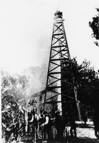
Norman No. 1 Oil Well Site is the site of an abandoned oil well, located at the northeast corner of Mill and First Streets in Neodesha, Kansas, USA. The well, which was drilled on November 28, 1892, was the first successful well in what is now known as the Mid-Continent oil field, kicking off a major oil boom in states from Kansas to Texas and Louisiana. The well site, now a small municipal park, was designated a National Historic Landmark in 1977.

The Ste. Genevieve National Historical Park, established in 2020, consists of part or the whole of the area of the Ste. Genevieve Historic District, which is a historic district encompassing much of the built environment of Ste. Genevieve, Missouri, United States. The city was in the late 18th century the capital of Spanish Louisiana, and, at its original location a few miles south, capital of French Louisiana as well. A large area of the city, including fields along the Mississippi River, is a National Historic Landmark District designated in 1960, for its historically French architecture and land-use patterns, while a smaller area, encompassing the parts of the city historically important between about 1790 and 1950, was named separately to the National Register of Historic Places in 2002.

This is a list of the National Register of Historic Places listings in Grand Forks County, North Dakota. This is intended to be a complete list of the properties and districts on the National Register of Historic Places in Grand Forks County, North Dakota, United States. The locations of National Register properties and districts for which the latitude and longitude coordinates are included below, may be seen in an online map.

The American Chicle Company Building, built in 1911, is located in the Gert Town neighborhood of New Orleans, Louisiana.

Deprato Mounds, also known as the Ferriday Mounds, is a multi-mound archaeological site located in Concordia Parish, Louisiana. The site shows occupation from the Troyville period to the Middle Coles Creek period. The largest mound at the site has been dated by radiocarbon analysis and decorated pottery to about 600 CE.
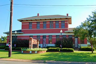
Bunkie station is an historic train station in Bunkie, Louisiana.
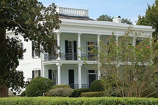
The St. Louis Plantation is a Southern plantation with a historic mansion located in Iberville Parish, Louisiana, United States.

The Joseph and Daniel Marsh House is a historic farmstead at 1119 Quechee Main Street, just outside the village Quechee in Hartford, Vermont. Built in 1793, it was the home of Joseph Marsh, one of Hartford's early settlers and the first Lieutenant Governor of Vermont. Now the Quechee Inn, the property was listed on the National Register of Historic Places in 1998.

The Winooski River Bridge, also known locally as the Checkered House Bridge, is a historic Pennsylvania through truss bridge, carrying U.S. Route 2 (US 2) across the Winooski River in Richmond, Vermont. Built in 1929, it is one of only five Pennsylvania trusses in the state, and was the longest bridge built in the state's bridge-building program that followed massive flooding in 1927. The bridge was listed on the National Register of Historic Places in 1990.

The Concordia Parish Courthouse, at 405 Carter Street in Vidalia in Concordia Parish, Louisiana, was built in 1939. It was listed on the National Register of Historic Places in 2004.

The New Iberia High School building is a former school house for New Iberia Senior High School and historic structure located at 415 Center Street in New Iberia, Louisiana. The building was listed on the National Register of Historic Places on March 17, 1994.

The Missouri Lumber and Mining Company (MLM) was a large timber corporation with headquarters and primary operations in southeast Missouri. The company was formed by Pennsylvania lumbermen who were eager to exploit the untapped timber resources of the Missouri Ozarks to supply lumber, primarily used in construction, to meet the demand of U.S. westward expansion. Its primary operations were centered in Grandin, a company town it built starting c. 1888. The lumber mill there grew to be the largest in the country at the turn of the century and Grandin's population peaked around 2,500 to 3,000. As the timber resources were exhausted, the company had to abandon Grandin around 1910. It continued timber harvesting in other parts of Missouri for another decade. While some of the buildings in Grandin were relocated, many of the remaining buildings were listed on the National Register of Historic Places in 1980 as part of the state's historic preservation plan which considered the MLM a significant technological and economic contributor to Missouri.

