Boynton, Oklahoma

Last updated

Boynton, Oklahoma
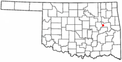
OKMap-doton-Boynton.PNG
Location of Boynton, Oklahoma
Coordinates: 35°38′58″N95°39′13″W / 35.64944°N 95.65361°W / 35.64944; -95.65361
Country United States
State Oklahoma
County Muskogee
Area
[1]
  Total0.42 sq mi (1.10 km2)
  Land0.42 sq mi (1.09 km2)
  Water0.01 sq mi (0.01 km2)
Elevation
[2]
614 ft (187 m)
Population
 (2020)
  Total161
  Density383.33/sq mi (147.96/km2)
Time zone UTC-6 (Central (CST))
  Summer (DST) UTC-5 (CDT)
ZIP code
74422
Area code(s) 539/918
FIPS code 40-08150 [3]
GNIS feature ID2411716 [2]

Boynton is a town in Muskogee County, Oklahoma, United States. The population was 248 at the 2010 census, a 9.5 percent decline from the figure of 274 recorded in 2000. [4]

Contents

History

Boynton was built in 1903 with the coming of the St. Louis – San Francisco Railway to the Muscogee (Creek) Nation. The post office was named for E. L. Boynton, chief engineer of the Missouri Coal and Railroad Company. [5] Boosted by an oil refinery and a brick factory, the town reached a peak population of 1,400 in the 1920 census. By 2000 the population had declined to 274. [6] [7] [8] The local school district, Boynton-Moton Public Schools, closed its high school in September 2010; in March 2011, the Oklahoma State Board of Education voted to revoke the district's accreditation and close the lower school as of June 2011. [9]

Geography

Boynton is 18 miles (29 km) from Muskogee. [6]

According to the United States Census Bureau, the town has a total area of 0.4 square miles (1.0 km2), all land.

Demographics

Historical population
CensusPop.Note
1910 679
1920 1,20477.3%
1930 1,2040.0%
1940 842−30.1%
1950 718−14.7%
1960 604−15.9%
1970 522−13.6%
1980 518−0.8%
1990 391−24.5%
2000 274−29.9%
2010 248−9.5%
2020 161−35.1%
U.S. Decennial Census [10]

2020 census

Boynton town, Oklahoma – Racial and ethnic composition
Note: the US Census treats Hispanic/Latino as an ethnic category. This table excludes Latinos from the racial categories and assigns them to a separate category. Hispanics/Latinos may be of any race.
Race / Ethnicity (NH = Non-Hispanic)Pop 2000 [11] Pop 2010 [12] Pop 2020 [13] % 2000% 2010% 2020
White alone (NH)75624327.37%25.00%26.71%
Black or African American alone (NH)1511297755.11%52.02%47.83%
Native American or Alaska Native alone (NH)161995.84%7.66%5.59%
Asian alone (NH)0000.00%0.00%0.00%
Pacific Islander alone (NH)0000.00%0.00%0.00%
Other race alone (NH)0000.00%0.00%0.00%
Mixed race or Multiracial (NH)30312810.95%12.50%17.39%
Hispanic or Latino (any race)2740.73%2.82%2.48%
Total274248161100.00%100.00%100.00%

2000 census

As of the census [3] of 2000, there were 274 people, 112 households, and 76 families residing in the town. The population density was 663.1 inhabitants per square mile (256.0/km2). There were 139 housing units at an average density of 336.4 per square mile (129.9/km2). The racial makeup of the town was 55.11% African American, 27.37% White, 6.20% Native American, 0.36% from other races, and 10.95% from two or more races. Hispanic or Latino of any race were 0.73% of the population.

There were 112 households, out of which 33.9% had children under the age of 18 living with them, 39.3% were married couples living together, 21.4% had a female householder with no husband present, and 32.1% were non-families. 31.3% of all households were made up of individuals, and 16.1% had someone living alone who was 65 years of age or older. The average household size was 2.45 and the average family size was 3.09.

In the town, the population was spread out, with 30.3% under the age of 18, 9.9% from 18 to 24, 21.9% from 25 to 44, 21.9% from 45 to 64, and 16.1% who were 65 years of age or older. The median age was 36 years. For every 100 females, there were 107.6 males. For every 100 females age 18 and over, there were 101.1 males.

The median income for a household in the town was $17,917, and the median income for a family was $25,000. Males had a median income of $25,417 versus $15,417 for females. The per capita income for the town was $18,419. About 22.4% of families and 25.5% of the population were below the poverty line, including 29.6% of those under the age of eighteen and 13.0% of those 65 or over.
Economy

The local economy is based on agricultural services. [6]

Related Research Articles

<span class="mw-page-title-main">Sherman County, Texas</span> County in Texas, United States

Sherman County is a county located in the U.S. state of Texas. As of the 2020 census, its population was 2,782. Its county seat is Stratford. The county was created in 1876 and organized in 1889. It is named for Sidney Sherman, who fought in the Texas Revolution. Though both Sherman County and Sherman, Texas, are named for the same person, the city of Sherman is located in Grayson County, about 430 miles to the southeast.

<span class="mw-page-title-main">Reed, Arkansas</span> Town in Arkansas, United States

Reed is a town in Desha County, Arkansas, United States. The population was 141 at the 2010 census.

<span class="mw-page-title-main">Golf, Florida</span> Village in Florida, United States

The Village of Golf is a village in Palm Beach County, Florida, United States. It's also part of the Miami metropolitan area of South Florida. As of 2020, the population recorded by the U.S. Census Bureau was 255.

<span class="mw-page-title-main">Ocean Ridge, Florida</span> Town in the state of Florida, United States

Ocean Ridge is a town in Palm Beach County, Florida, United States. The town is part of the Miami metropolitan area of South Florida. The population was 1,830 at the 2020 US census.

<span class="mw-page-title-main">Pace, Mississippi</span> Town in Mississippi, United States

Pace is a town in Bolivar County, Mississippi, United States. Per the 2020 census, the population was 183.

<span class="mw-page-title-main">Falcon, Mississippi</span> Town in Mississippi, United States

Falcon is a town in Quitman County, Mississippi. The population was 116 at the 2020 census.

<span class="mw-page-title-main">Baker, Missouri</span> Village in Missouri, United States

Baker is an inactive incorporated village in Stoddard County, Missouri, United States. Per the 2020 census, the population was 3. As of 2017, it is Missouri's smallest incorporated settlement.

<span class="mw-page-title-main">Ansonville, North Carolina</span> Town in North Carolina, United States

Ansonville is a town in Anson County, North Carolina, United States. The population was 440 at the 2020 census. The town has a total area of 1.5 square miles (3.8 km2), all land. It is located on the northern edge of Anson County, about a mile west of the Pee Dee River.

Boardman is a town in Columbus County, North Carolina, United States. Per the 2020 census, the population was 166.

<span class="mw-page-title-main">Oak City, North Carolina</span> Town in North Carolina, United States

Oak City, formerly known as Goose Nest, is a town in Martin County, North Carolina, United States. The population was 266 at the 2020 census.

<span class="mw-page-title-main">Langston, Oklahoma</span> Town in Oklahoma, United States

Langston is a town in Logan County, Oklahoma, United States, and is part of the Oklahoma City Metropolitan Statistical Area. The population was 1,619 as of the 2020 United States census. Langston is home to Langston University, the only historically black college in Oklahoma.

Meridian is a town in eastern Logan County, Oklahoma, United States. The population was 38 at the 2010 census, a decline of 29.5 percent from the figure of 54 in 2000. It is part of the Oklahoma City Metropolitan Statistical Area. The community name was chosen because of its location on the Indian meridian.

<span class="mw-page-title-main">Langley, Oklahoma</span> Town in Oklahoma, United States

Langley is a town in Mayes County, Oklahoma, United States. The population was 819 at the 2010 census.

<span class="mw-page-title-main">Oktaha, Oklahoma</span> Town in Oklahoma, United States

Oktaha is a town in Muskogee County, Oklahoma, United States.

<span class="mw-page-title-main">Summit, Oklahoma</span> Town in Oklahoma, United States

Summit is a town in Muskogee County, Oklahoma, United States. It was originally called South Muskogee when it was platted in 1910, and is one of thirteen all-black towns still surviving at the beginning of the 21st century. The population was 139 at the 2010 census, a 38.5 percent decline from the figure of 226 recorded in 2000. Summit, is located in Muskogee County six miles southwest of the city of Muskogee. The community retained a post office as early as 1896. Like many of the other Black towns previously mentioned, was a stopover destination on the Missouri, Kansas and Texas Railway and had a depot in the community. It is said that the town may have been named Summit because it was the highest point on the railroad between Arkansas and the North Canadian rivers.

<span class="mw-page-title-main">Wainwright, Oklahoma</span> Town in Oklahoma, United States

Wainwright is a town in Muskogee County, Oklahoma, United States. The town was named for a local merchant, William Henry Wainwright. The population was 165 at the 2010 census, a decline of 16.2 percent from the figure of 197 recorded in 2000.

<span class="mw-page-title-main">Warner, Oklahoma</span> Town in Muskogee County, Oklahoma, United States

Warner is a town in Muskogee County, Oklahoma, United States. The population was 1,641 at the 2010 census, an increase of 14.8 percent over the figure of 1,430 recorded in 2000. The town is home to one of the two Connors State College campuses.

<span class="mw-page-title-main">Arcadia, Oklahoma</span> Town in Oklahoma County, Oklahoma

Arcadia is a town in Oklahoma County, Oklahoma, United States, and a part of the Oklahoma City metropolitan area. The population was 247 at the 2010 census, a decrease of 11.5 percent from the figure of 279 in 2000.

<span class="mw-page-title-main">Forest Park, Oklahoma</span> Town in Oklahoma, United States

Forest Park is a town in Oklahoma County, Oklahoma, United States, and a part of the Oklahoma City metropolitan area. The population was 998 at the 2010 census.

<span class="mw-page-title-main">Northfork, West Virginia</span> Town in West Virginia, United States

Northfork is a town in McDowell County, West Virginia, United States, located on U.S. Route 52 between Welch and Bluefield.

References

  1. "ArcGIS REST Services Directory". United States Census Bureau. Retrieved September 20, 2022.
  2. 1 2 U.S. Geological Survey Geographic Names Information System: Boynton, Oklahoma
  3. 1 2 "U.S. Census website". United States Census Bureau . Retrieved January 31, 2008.
  4. CensusViewer:Boynton, Oklahoma Population. Retrieved October 11, 2013.
  5. Muskogee Phoenix. "How places got their names." Archived July 12, 2012, at archive.today June 5, 2007. Retrieved October 11, 2013.
  6. 1 2 3 Ellen Collins Johnson, "Boynton," Encyclopedia of Oklahoma History and Culture. Accessed May 2, 2015.
  7. Susan Hylton, "Boynton investigated on allegations of nepotism, Open Meeting Act violations", Tulsa World , September 1, 2010.
  8. Susan Hylton, "Ex-Boynton official pleads guilty to nepotism", Tulsa World , October 9, 2010.
  9. Wendy Burton, "State: Boynton must close", Muskogee Phoenix , March 24, 2011.
  10. "Census of Population and Housing". Census.gov. Retrieved June 4, 2015.
  11. "P004: Hispanic or Latino, and Not Hispanic or Latino by Race – 2000: DEC Summary File 1 – Boynton town, Oklahoma". United States Census Bureau .
  12. "P2: Hispanic or Latino, and Not Hispanic or Latino by Race – 2010: DEC Redistricting Data (PL 94-171) – Boynton town, Oklahoma". United States Census Bureau .
  13. "P2: Hispanic or Latino, and Not Hispanic or Latino by Race – 2020: DEC Redistricting Data (PL 94-171) – Boynton town, Oklahoma". United States Census Bureau .