Brownville, Nebraska | |
---|---|
Coordinates: 40°23′49″N95°39′34″W / 40.39694°N 95.65944°W | |
Country | United States |
State | Nebraska |
County | Nemaha |
Area | |
• Total | 0.65 sq mi (1.69 km2) |
• Land | 0.65 sq mi (1.69 km2) |
• Water | 0.00 sq mi (0.00 km2) |
Elevation | 958 ft (292 m) |
Population | |
• Total | 142 |
142 | |
• Density | 220/sq mi (84/km2) |
Time zone | UTC-6 (Central (CST)) |
• Summer (DST) | UTC-5 (CDT) |
ZIP code | 68321 |
Area code | 402 |
FIPS code | 31-06750 [3] |
GNIS feature ID | 0827698 [4] |
Website | www |
Brownville is a village in Nemaha County, Nebraska, United States. The population was 142 at the 2020 census. [2]
Established in 1854 and incorporated in 1856, Brownville was the largest town in the Nebraska Territory, with a population of 1,309 by 1880. Bordering slave-holding Missouri, the town became an important port on the Missouri River. Daniel Freeman, the first homesteader to file a claim under the Homestead Act of 1862, staked his claim at a New Year's Eve party in Brownville.
The rise of the railroad was ultimately Brownville's undoing. The railroads siphoned traffic away from the Missouri River's steamboats. Brownville's attempt to secure a railroad of its own was severely botched and led to immense tax increases to pay the bonds for the failed venture. This drove most of the population away and led to the county seat being transferred to Auburn in 1885. [5] In 1856 Thomas Weston Tipton moved to the town to serve as a minister. He later became a U.S. Senator, and ran an unsuccessful campaign for Governor of Nebraska. Omaha land magnates Herman and Augustus Kountze held large holdings in the early town.
After the American Civil War, David Mercer established a law practice in the town. Mercer later served as a long-time U.S. Representative from Nebraska. The Nebraska State Fair was held in the town in 1870 and 71. That year Eugene Gilmore, the future acting Governor-General of the Philippines, was born in the town.
The Brownville Bridge was built over the Missouri River in 1939. Today it is on the National Register of Historic Places. Owing to its place in Nebraska history, Brownville is primarily a tourist attraction with several old houses opened for tours or converted into museums. Art galleries and wineries in and near Brownville have also helped to make the town an increasingly attractive getaway for residents of the region's larger cities. [6] Omaha's River City Star was built in the town in 1967, and was originally named the Belle of Brownville. The Governor Furnas Arboretum was planted in the city in 1992. The arboretum is named in honor of Nebraska's second governor, Robert W. Furnas, the signer of the first declaration of Arbor Day. The Cooper Nuclear Station is south of the city. In 1995 a mild tornado blew through the town.
According to the United States Census Bureau, the village has a total area of 0.65 square miles (1.68 km2), all land. [7]
Climate data for Brownville, Nebraska | |||||||||||||
---|---|---|---|---|---|---|---|---|---|---|---|---|---|
Month | Jan | Feb | Mar | Apr | May | Jun | Jul | Aug | Sep | Oct | Nov | Dec | Year |
Record high °F (°C) | 70 (21) | 81 (27) | 91 (33) | 99 (37) | 102 (39) | 109 (43) | 110 (43) | 109 (43) | 107 (42) | 98 (37) | 84 (29) | 78 (26) | 110 (43) |
Mean daily maximum °F (°C) | 34 (1) | 41 (5) | 53 (12) | 65 (18) | 76 (24) | 86 (30) | 90 (32) | 88 (31) | 80 (27) | 68 (20) | 50 (10) | 37 (3) | 64 (18) |
Mean daily minimum °F (°C) | 14 (−10) | 20 (−7) | 30 (−1) | 41 (5) | 52 (11) | 62 (17) | 66 (19) | 64 (18) | 55 (13) | 43 (6) | 30 (−1) | 18 (−8) | 41 (5) |
Record low °F (°C) | −22 (−30) | −23 (−31) | −21 (−29) | 7 (−14) | 26 (−3) | 39 (4) | 43 (6) | 38 (3) | 23 (−5) | 13 (−11) | −5 (−21) | −27 (−33) | −27 (−33) |
Average precipitation inches (mm) | 0.84 (21) | 1.09 (28) | 2.46 (62) | 2.93 (74) | 4.27 (108) | 3.73 (95) | 4.41 (112) | 3.49 (89) | 3.54 (90) | 2.49 (63) | 2.02 (51) | 1.09 (28) | 32.36 (821) |
Average snowfall inches (cm) | 5.7 (14) | 6.2 (16) | 5.3 (13) | 1 (2.5) | 0 (0) | 0 (0) | 0 (0) | 0 (0) | 0 (0) | 0.2 (0.51) | 1.7 (4.3) | 5.7 (14) | 25.8 (64.31) |
Source: [8] |
Census | Pop. | Note | %± |
---|---|---|---|
1860 | 425 | — | |
1870 | 1,305 | 207.1% | |
1880 | 1,309 | 0.3% | |
1890 | 980 | −25.1% | |
1900 | 718 | −26.7% | |
1910 | 457 | −36.4% | |
1920 | 463 | 1.3% | |
1930 | 426 | −8.0% | |
1940 | 581 | 36.4% | |
1950 | 357 | −38.6% | |
1960 | 243 | −31.9% | |
1970 | 174 | −28.4% | |
1980 | 203 | 16.7% | |
1990 | 148 | −27.1% | |
2000 | 146 | −1.4% | |
2010 | 132 | −9.6% | |
2020 | 139 | 5.3% | |
2021 (est.) | 142 | [2] | 2.2% |
U.S. Decennial Census [9] |
As of the census [10] of 2010, there were 132 people, 73 households, and 40 families residing in the village. The population density was 203.1 inhabitants per square mile (78.4/km2). There were 103 housing units at an average density of 158.5 per square mile (61.2/km2). The racial makeup of the village was 97.7% White, 0.8% Native American, 0.8% from other races, and 0.8% from two or more races. Hispanic or Latino of any race were 3.0% of the population.
There were 73 households, of which 9.6% had children under the age of 18 living with them, 46.6% were married couples living together, 1.4% had a female householder with no husband present, 6.8% had a male householder with no wife present, and 45.2% were non-families. 42.5% of all households were made up of individuals, and 20.5% had someone living alone who was 65 years of age or older. The average household size was 1.81 and the average family size was 2.30.
The median age in the village was 60.8 years. 6.8% of residents were under the age of 18; 6.9% were between the ages of 18 and 24; 7.6% were from 25 to 44; 40.1% were from 45 to 64; and 38.6% were 65 years of age or older. The gender makeup of the village was 53.0% male and 47.0% female.
As of the census [3] of 2000, there were 146 people, 74 households, and 40 families residing in the village. The population density was 233.9 inhabitants per square mile (90.3/km2). There were 106 housing units at an average density of 169.8 per square mile (65.6/km2). The racial makeup of the village was 99.32% White, and 0.68% from two or more races.
There were 74 households, out of which 20.3% had children under the age of 18 living with them, 44.6% were married couples living together, 5.4% had a female householder with no husband present, and 44.6% were non-families. 40.5% of all households were made up of individuals, and 17.6% had someone living alone who was 65 years of age or older. The average household size was 1.97 and the average family size was 2.63.
In the village, the population was spread out, with 18.5% under the age of 18, 5.5% from 18 to 24, 19.2% from 25 to 44, 34.2% from 45 to 64, and 22.6% who were 65 years of age or older. The median age was 51 years. For every 100 females, there were 117.9 males. For every 100 females age 18 and over, there were 108.8 males.
The median income for a household in the village was $34,375, and the median income for a family was $51,000. Males had a median income of $35,750 versus $28,438 for females. The per capita income for the village was $20,928. There were 11.5% of families and 15.9% of the population living below the poverty line, including 15.2% of under eighteens and 17.9% of those over 64.
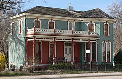
Brownville sits in the Loess Hills above the Missouri River Valley. It is home to one of Nebraska's two nuclear power plants. The Cooper Nuclear Station is owned and operated by the Nebraska Public Power District. U.S. Route 136, which meets Nebraska Highway 67 near Brownville, runs through the town, exiting the state via the Brownville Bridge. At Brownville bicycle riders along the Lewis & Clark Trail Bicycle Route can choose between the Steamboat Trace or the Hamburg Option.
Nemaha County is a county in the U.S. state of Nebraska. As of the 2020 United States Census, the population was 7,074. Its county seat is Auburn.
Fortescue is a village in southwestern Holt County, Missouri, United States. The population was 21 at the 2020 census.
Holstein is a village in Adams County, Nebraska, United States. The population was 188 at the 2020 census. It is part of the Hastings, Nebraska Micropolitan Statistical Area.
Petersburg is a village in Boone County, Nebraska, United States. The population was 333 at the 2010 census. Petersburg is the site of a memorial to Logan Fontenelle, an Omaha chief who was killed nearby, in a skirmish with Brulé and Arapaho in 1855, at the site of the present-day Olson Nature Preserve.
Decatur is a village in Burt County, Nebraska, United States, adjacent to the upper Missouri River. The population was 481 at the 2010 census. This town is named after one of its incorporators, Stephen Decatur. It developed around a trading post established by Colonel Peter Sarpy, the namesake for Sarpy County in the state.
Bruno is a village in Butler County, Nebraska, United States. The population was 99 at the 2010 census.
Octavia is a village in Butler County, Nebraska, United States. The city had 127 residents as of 2010 census, according to the United States Census Bureau.
Ong is a village in Clay County, Nebraska, United States. The population was 49 at the 2020 census. It is part of the Hastings, Nebraska Micropolitan Statistical Area.
Hubbard is a village in Dakota County, Nebraska, United States. It is part of the Sioux City, IA–NE–SD Metropolitan Statistical Area. The population was 236 at the 2010 census.
Bennington is a city in Douglas County, Nebraska, United States. The population was 2,026 at the 2020 U.S. Census.
Stockham is a village in Hamilton County, Nebraska, United States. The population was 44 at the 2010 census.
Stuart is a village in Holt County, Nebraska, United States. The population was 590 at the 2010 census.
Niobrara is a village in Knox County, Nebraska, United States. The population was 363 at the 2020 census.
Auburn is a city in Nemaha County, Nebraska, United States, and its county seat. The population was 3,470 at the 2020 census.
Creston is a village in Platte County, Nebraska, United States. The population was 203 at the 2010 census.
Dorchester is a village in Saline County, Nebraska, United States. It is thirty-eight miles southwest from the Lincoln, Nebraska metropolitan area. The population was 596 at the 2020 census.
Springfield is a small town in Sarpy County, Nebraska, United States. The population was 1,501 at the 2020 census.
Brownville is an unincorporated community and census-designated place (CDP) in Old Bridge Township, Middlesex County, New Jersey, United States. As of the 2020 census, the population was 2,746, up from 2,383 in 2010.
Glen Park is a village in Jefferson County, New York, United States. The population was 502 at the 2010 census. The village is on the border of the towns of Brownville and Pamelia and is immediately northwest of Watertown.
Brownville is a village in Jefferson County, New York, United States. The population was 1,119 at the 2010 census, up from 1,022 in 2000. The village is named after Jacob Brown, an early settler and developer.